 My GeoNetwork catalogue
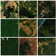
HyBiomass - EnMAP L2A / GEDI L4A - Near-Global
Comprehensive evaluation of geospatial foundation models (Geo-FMs) requires benchmarking across diverse tasks, sensors, and geographic regions. However, most existing benchmark datasets are limited to segmentation or classification tasks, and focus on specific geographic areas. To address this gap, we introduce a globally distributed dataset for forest aboveground biomass (AGB) estimation, a pixelwise regression task. This benchmark dataset combines co-located hyperspectral imagery (HSI) from the Environmental Mapping and Analysis Program (EnMAP) satellite and predictions of AGB density estimates derived from the global ecosystem dynamics investigation (GEDI) lidars, covering seven continental regions. Our experimental results on this dataset demonstrate that the evaluated Geo- FMs can match or, in some cases, surpass the performance of a baseline U-Net, especially when fine-tuning the encoder. By releasing this globally distributed hyperspectral benchmark dataset, we aim to facilitate the development and evaluation of Geo-FMs for HSI applications. Leveraging this dataset additionally enables research into geographic bias and the generalization capacity of Geo-FMs. Published in IEEE Geoscience and Remote Sensing Letters: https://ieeexplore.ieee.org/document/11164504 .
Simple
- Date (Creation)
- 2026-01-12T12:48:00
- Citation identifier
- https://geoservice.dlr.de/catalogue/srv/metadata/041fc7b2-c6da-44cf-9c03-526e85c7ef87
- Presentation form
- Digital map
- Status
- Completed
- Maintenance and update frequency
- As needed
-
GEMET - INSPIRE themes, version 1.0
-
-
Land cover
-
Orthoimagery
-
- Keywords
-
-
DLR
-
EOC
-
EnMAP
-
Imagery
-
Hyperspectral
-
Geospatial Foundation Models
-
Hyperspectral Sensor
-
Forest Biomass Estimation
-
Regression
-
- Use limitation
-
Nutzungseinschränkungen: Das DLR ist nicht haftbar für Schäden, die sich aus der Nutzung ergeben. / Use Limitations: DLR not liable for damage resulting from use.
- Access constraints
- Other restrictions
- Other constraints
- Öffentlicher Zugriff beschränkt entsprechend Artikel 13(1)(e) der INSPIRE-Richtlinie: e) aufgrund nachteiliger Auswirkungen auf die Rechte des geistigen Eigentums
- Use constraints
- Other restrictions
- Other constraints
-
Nutzungsbedingungen: Lizenz, https://www.enmap.org/data_access/ Terms of use: https://www.enmap.org/data_access/
- Spatial representation type
- Grid
- Denominator
- 60000
- Language
- English
- Character set
- UTF8
- Topic category
-
- Imagery base maps earth cover
))
- Begin date
- 2022-05-01T00:00:00
- End date
- 2024-05-01T00:00:00
- Number of dimensions
- 2
- Dimension name
- Column
- Dimension size
- 128
- Resolution
- 10 m
- Dimension name
- Row
- Dimension size
- 128
- Resolution
- 30 m
- Cell geometry
- Area
- Transformation parameter availability
- No
- Distribution format
-
-
GeoTIFF
()
-
GeoTIFF
()
- OnLine resource
- EOC Download Service ( WWW:LINK-1.0-http--link )
- OnLine resource
- Scientific publication ( WWW:LINK-1.0-http--link )
- OnLine resource
- EOC Geoservice Dataset ( WWW:LINK-1.0-http--link )
- Hierarchy level
- Series
Domain consistency
- Measure identification
- INSPIRE / Conformity_001
Conformance result
- Date (Publication)
- 2010-12-08
- Explanation
-
See the referenced specification.
- Pass
- Yes
- Statement
-
Input data: HyBiomass is derived from DLR EnMAP L2A data and GEDI L4A Footprint Level Aboveground Biomass Density.
- Description
-
Processing information: HyBiomass includes EnMAP tiles selected for SpectralEarth, which have been filtered for clouds and other atmospheric artifacts. We refer to the publication for details on quality filters applied to the GEDI shots. The co-located tiles have been patchified into 128x128 spatial pixels.
Quality assurance: The data quality aligns with that of the EnMAP L2A data and GEDI L4A product.
- File identifier
- 041fc7b2-c6da-44cf-9c03-526e85c7ef87 XML
- Metadata language
- English
- Character set
- UTF8
- Hierarchy level
- Series
- Hierarchy level name
-
Dataseries
- Date stamp
- 2026-01-20T13:46:46
- Metadata standard name
-
ISO 19115-1:2014/19139
- Metadata standard version
-
2003/Cor.1:2006
Overviews

Spatial extent
Provided by
