 My GeoNetwork catalogue
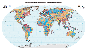
Global Groundwater Vulnerability to Floods and Droughts (WHYMAP GWV)
The World-wide Hydrogeological Mapping and Assessment Programme (WHYMAP) provides data and information about the earth´s major groundwater resources. The Map of Global Groundwater Vulnerability to Floods and Droughts indicates the vulnerability level of groundwater resources of the earth. It presents the intrinsic vulnerability of groundwater systems and the sensitivity or resistance of those systems to natural disasters.
Simple
- Alternate title
-
WHYMAP GWV
- Date (Publication)
- 2015-04-01
- Edition
-
v1.0
- Citation identifier
- 3a16e5a7-c473-442b-88b4-6ee1ff20b98b
- Status
- Completed
-
GEMET - INSPIRE themes, version 1.0
-
-
Geologie
-
Geology
-
-
GEMET - Concepts, version 2.4
-
-
Grundwasser
-
Hydrogeologie
-
Groundwater
-
Hydrogeology
-
- Theme
-
-
Aquifer
-
Grundwasserneubildung
-
Groundwater recharge
-
Grundwasservorkommen
-
Groundwater resources
-
Grundwasserentnahme
-
Groundwater abstraction
-
- Place
-
-
Weltweit
-
World-wide
-
- Access constraints
- Other restrictions
- Other constraints
- Es gelten keine Zugriffsbeschränkungen
- Use constraints
- Other restrictions
- Other constraints
-
Allgemeine Geschäftsbedingungen, s.: https://www.bgr.bund.de/AGB - General terms and conditions, s. https://www.bgr.bund.de/AGB_en ; Die bereitgestellten Informationen sind bei Weiterverwendung wie folgt zu zitieren: Datenquelle: WHYMAP, (C) BGR Hannover & UNESCO Paris
- Spatial representation type
- Vector
- Denominator
- 25000000
- Language
- English
- Character set
- UTF8
- Topic category
-
- Geoscientific information
))
- Unique resource identifier
- EPSG:4326
- Distribution format
-
-
Shapefile
(
n/a
)
-
Shapefile
(
n/a
)
- Transfer size
- 52
- OnLine resource
-
WHYMAP GWV (Shapefile)
WHYMAP GWV im Format ESRI Shape
- OnLine resource
- Website
- OnLine resource
- Karte im BGR-Geoviewer
- Hierarchy level
- Dataset
- Statement
-
World-wide Hydrogeological Mapping and Assessment Programme (WHYMAP)
- File identifier
- 0cf5c86b-ac00-4c3d-845b-792f8bdce023 XML
- Metadata language
- English
- Character set
- UTF8
- Hierarchy level
- Dataset
- Hierarchy level name
-
Grundwasser
- Date stamp
- 2025-03-12
- Metadata standard name
-
INSPIRE Metadata Implementing Rules: Technical Guidelines based on EN ISO 19115 and EN ISO 19119
- Metadata standard version
-
n/a
Overviews
Spatial extent
Provided by
