 My GeoNetwork catalogue
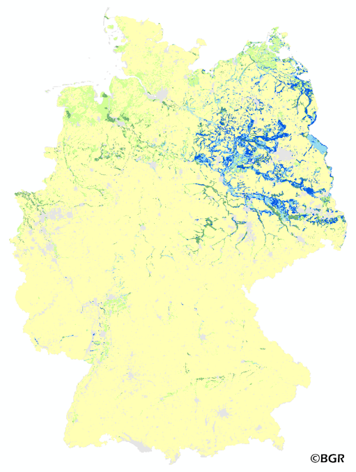
Mean annual rate of capillary rise in Germany
The map of the annual rate of capillary rise from the groundwater zone into the effective rooting zone of the soils in Germany gives an overview of the amount of groundwater that passes through evapotranspiration to the surface.
Simple
- Alternate title
-
KA1000_250
- Date (Creation)
- 2014-07-14
- Date (Publication)
- 2015-08-03
- Edition
-
Version 1.0
- Citation identifier
- 95695182-e1b3-4e1a-97aa-9f174a77f6a8
- Status
- Completed
-
GEMET - Concepts, version 2.4
-
-
Boden
-
Bodenkarte
-
Grundwasser
-
Bodenkunde
-
Bodenfeuchtigkeit
-
Bodenwasser
-
Bodenwasserhaushalt
-
-
GEMET - INSPIRE themes, version 1.0
-
-
Boden
-
Soil
-
-
SGD-Liste
-
-
Grundwasserflurabstand
-
Grundwasseroberfläche
-
Transport
-
-
Freies Schlagwort
-
-
kapillarer Aufstieg
-
- Place
-
-
Bundesrepublik Deutschland
-
- Access constraints
- Other restrictions
- Other constraints
- Es gelten keine Zugriffsbeschränkungen
- Use constraints
- Other restrictions
- Other constraints
-
Allgemeine Geschäftsbedingungen, siehe https://www.bgr.bund.de/AGB - General terms and conditions, see https://www.bgr.bund.de/AGB_en . Die bereitgestellten Informationen sind bei Weiterverwendung wie folgt zu zitieren: Datenquelle: KA1000_250 V1.0, (c) BGR, Hannover, 2015.
- Spatial representation type
- Grid
- Denominator
- 1000000
- Language
- Deutsch
- Character set
- UTF8
- Topic category
-
- Geoscientific information
))
- Geographic identifier
- Regionalschlüssel / 000000000000
- Unique resource identifier
- EPSG:3034
- Distribution format
-
-
georef. TIFF
(
n/a
)
-
georef. TIFF
(
n/a
)
- Transfer size
- 4
- OnLine resource
-
KA1000_250 (georef. TIFF)
KA1000_250 im Format georeferenziertes TIFF
- OnLine resource
- Karte im BGR-Geoviewer
- Hierarchy level
- Dataset
Conformance result
- Date (Publication)
- 2010-12-08
- Explanation
-
siehe dazu die angegebene Durchführungsbestimmung
- Statement
-
Bodendaten aus BÜK1000N V2.31 (BGR), Landnutzungsdaten aus Corine Land Cover 2006 (UBA/DLR), Klimadaten des Deutschen Wetterdienstes der Referenzperiode 1961-1990 (DWD) Reliefinformationen aus dem DGM50 des Bundesamtes für Kartographie und Geodäsie (BKG).
- File identifier
- 19727b0c-8053-4f67-b1cb-fb478a383712 XML
- Metadata language
- Deutsch
- Character set
- UTF8
- Hierarchy level
- Dataset
- Hierarchy level name
-
Boden
- Date stamp
- 2023-08-22
- Metadata standard name
-
INSPIRE Metadata Implementing Rules: Technical Guidelines based on EN ISO 19115 and EN ISO 19119
- Metadata standard version
-
n/a
Overviews
Spatial extent
Provided by
