 My GeoNetwork catalogue
Processed seismic data of Cruise BGR78-1 1978
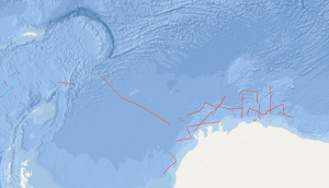
The preceding results of the Deep Sea Drilling Project/International Program of Ocean Drilling (DSDP/IPOD) have shown that inspection of borehole cores in the Southern Ocean and around Antarctica are necessary for reconstruction of the development of the Atlantic Ocean and for the understanding of the sedimentary deposition which is strongly affected by the palaeo-oceanographic processes. As the geological development of the Weddell Sea plays a key role for the reconstruction of the south-american and african part of the former supercontinent Gondwana, the Federal Institute for Geosciences and Natural Resources (BGR) has decided to conduct a synoptic geophysical survey in the eastern Weddell Sea and in front of the eastern Antarctic continental margin. This survey has been designed as a prearrangement for a larger "presite" program for preparation of future DSDP/IPOD sites. The main focus of the geophysical survey during the first leg of cruise BGR78 from 5th of January to 13th of February 1978 with M.S. EXPLORA has been put on the continental margin of the south-eastern Weddell Sea and eastern Antarctica between 20°E and 30°W and south of 67°S. Especially the lines BGR78-03 to BGR78-23 of seismic reflection measurements have been carried out in this region which were affected by heavy ice conditions at this time. Additionally, on 43 stations sonobuoy refraction measurements have been conducted.
Simple
- Alternate title
-
BGR78-1 1978
- Date (Creation)
- 1978-02-13
- Citation identifier
- 77a3af74-68be-5e35-bf41-457d9336493a
- Status
- Completed
-
GEMET - INSPIRE themes, version 1.0
-
-
Geologie
-
geology
-
-
GEMET - Concepts, version 2.4
-
-
geophysics
-
Geophysik
-
raw material
-
Rohstoff
-
- Theme
-
-
Marine geology
-
Meeresgeologie
-
Seismics
-
Seismik
-
Two-dimensional seismic reflection
-
zweidimensionale Reflektionsseismik
-
- Place
-
-
Scotia Sea
-
Weddell Sea
-
Lazarev Sea
-
Riiser-Larsen Sea
-
Southern Ocean
-
Eastern Antarctic Continental Margin
-
Scotiasee
-
Weddell-Meer
-
Lasarew-See
-
Riiser-Larsen-See
-
Ostantarktischer Kontinentalrand
-
- Access constraints
- Other restrictions
- Other constraints
- Es gelten keine Zugriffsbeschränkungen
- Use constraints
- Other restrictions
- Other constraints
-
Allgemeine Geschäftsbedingungen, siehe http://www.bgr.bund.de/AGB - General terms and conditions, see http://www.bgr.bund.de/AGB_en . Die bereitgestellten Informationen sind bei Weiterverwendung wie folgt zu zitieren: Datenquelle: BGR78-1 1978, (c) BGR, Hannover, 2019
- Spatial representation type
- Vector
- Language
- English
- Character set
- UTF8
- Topic category
-
- Geoscientific information
))
- Unique resource identifier
- EPSG:4326
- Distribution format
-
-
Shapefile
(
n/a
)
-
Shapefile
(
n/a
)
- Transfer size
- 2
- OnLine resource
-
BGR78-1 1978 (Shapefile)
BGR78-1 1978 im Format ESRI Shape
- OnLine resource
- Profile BGR78-01
- OnLine resource
- Profile BGR78-02
- OnLine resource
- Profile BGR78-03
- OnLine resource
- Profile BGR78-05
- OnLine resource
- Profile BGR78-06
- OnLine resource
- Profile BGR78-07
- OnLine resource
- Profile BGR78-08
- OnLine resource
- Profile BGR78-09
- OnLine resource
- Profile BGR78-10
- OnLine resource
- Profile BGR78-11
- OnLine resource
- Profile BGR78-12
- OnLine resource
- Profile BGR78-13
- OnLine resource
- Profile BGR78-14
- OnLine resource
- Profile BGR78-16
- OnLine resource
- Profile BGR78-18
- OnLine resource
- Profile BGR78-19
- OnLine resource
- Profile BGR78-20
- OnLine resource
- Profile BGR78-20A
- OnLine resource
- Profile BGR78-21
- OnLine resource
- Profile BGR78-22
- OnLine resource
- Profile BGR78-22A
- OnLine resource
- Profile BGR78-23
- OnLine resource
- Karte im BGR-Geoviewer
- Hierarchy level
- Dataset
Conformance result
- Date (Publication)
- 2010-12-08
- Explanation
-
siehe dazu die angegebene Durchführungsbestimmung
- Statement
-
During the period from 5th January 1978 to 13th February 1978 BGR acquired seismic lines in the Southern Ocean, in the Weddell Sea, in the Lazarev Sea and the Riiser-Larsen Sea along the eastern antarctic continental margin. The lines BGR78-04 and BGR78-17 consist of raw data. The lines BGR78-01, BGR78-02, BGR78-03, BGR78-05, BGR78-06, BGR78-07, BGR78-08, BGR78-09, BGR78-10, BGR78-11, BGR78-12, BGR78-13, BGR78-14, BGR78-16, BGR78-18, BGR78-19, BGR78-20, BGR78-20A, BGR78-21, BGR78-22, BGR78-22A and BGR78-23 are stacked data.
- File identifier
- 1aba1a87-7d19-4ccd-8d20-577d1f71260c XML
- Metadata language
- English
- Character set
- UTF8
- Parent identifier
-
Marine Seismic Survey Profiles (MSSP)
06a73c56-06a2-40d8-b806-466222b0760d
- Hierarchy level
- Dataset
- Hierarchy level name
-
Geophysik
- Date stamp
- 2023-11-14
- Metadata standard name
-
INSPIRE Metadata Implementing Rules: Technical Guidelines based on EN ISO 19115 and EN ISO 19119
- Metadata standard version
-
n/a
Overviews
Spatial extent
Provided by
