 My GeoNetwork catalogue
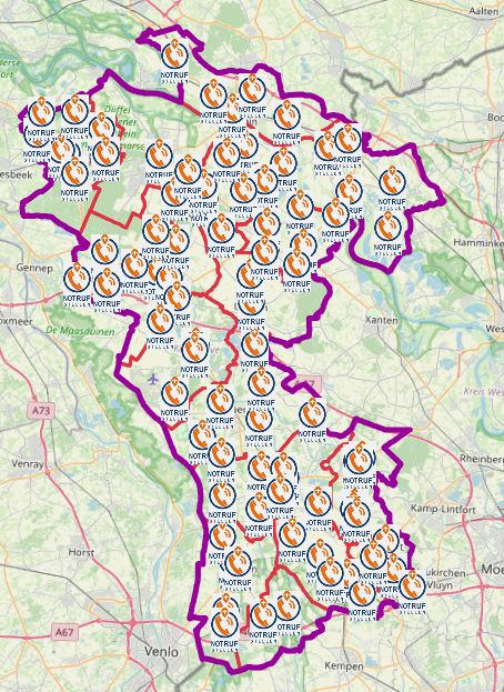
Notrufstellen Kreis Kleve
Im Falle eines Stromausfalls sind die Feuerwehrgerätehäuser in allen Ortschaften der Städte und Gemeinden als Notrufstellen besetzt.
Dorthin kann sich die Bevölkerung wenden, um auch beim Ausfall der üblichen Kommunikationswege Notrufe an die Kreisleitstelle (Telefon 112) abzusetzen.
Es handelt sich um keine dauerhafte Einrichtungen und werden von den Städten und Gemeinden bei Bedarf im Fall eines Notfalls besetzt.
Simple
- Date (Publication)
- 2023-06-30T00:00:00.000+02:00
- Citation identifier
- https://registry.gdi-de.org/id/de.nw/4a2e167b-5446-4c40-99c2-fd5fe3c10241
+49 2821 85-500
https://www.kreis-kleve.de
- Maintenance and update frequency
- As needed
- Update scope
- Dataset
- Keywords
-
-
Kreis Kleve
-
Bedburg-Hau
-
Emmerich am Rhein
-
Emmerich
-
Geldern
-
Goch
-
Issum
-
Kalkar
-
Kerken
-
Wallfahrtsstadt Kevelaer
-
Kevelaer
-
Kranenburg
-
Kleve
-
Rees
-
Rheurdt
-
Straelen
-
Uedem
-
Wachtendonk
-
Weeze
-
NW
-
NRW
-
Nordrhein-Westfalen
-
Notfallanlaufstellen
-
Notfall
-
Leuchttürme
-
Leuchtturm
-
Blackout
-
05154
-
Anlaufstelle
-
Notfall-Infopunkte
-
Notfallinfopunkt
-
Notrufstelle
-
Open Data
-
opendata
-
- Theme
-
-
SOCI
-
- Use constraints
- Other restrictions
- Other constraints
-
Open Data Commons Open Database License (ODbL)
- Other constraints
-
{"id":"odbl","name":"Open Data Commons Open Database License (ODbL)","url":" https://www.opendefinition.org/licenses/odc-odbl","quelle":""}
- Other constraints
-
© OpenStreetMap-Mitwirkende
- Other constraints
-
Quellenvermerk: https://www.openstreetmap.org/copyright
- Access constraints
- Other restrictions
- Other constraints
- Es gelten keine Zugriffsbeschränkungen
- Language
- Deutsch
- Topic category
-
- Health
- Society
- Utilities communication
Extent
- Extent type code
- Yes

))
- Extent type code
- Yes
- Geographic identifier
- Kreis Kleve, Nordrhein-Westfalen, Deutschland (administrative) (05154)
- Code
- 051540000000
- Unique resource identifier
- EPSG 25832: ETRS89 / UTM Zone 32N
- Distribution format
-
- OnLine resource
- WFS Notfallanlaufstellen KLE KR VIE WES
- OnLine resource
- WMS Notfallanlaufstellen KLE KR VIE WES
- OnLine resource
- Dienst "WMS Notfallanlaufstellen KLE KR VIE WES" (GetCapabilities) ( OGC Web Map Service )
- OnLine resource
- Dienst "WFS Notfallanlaufstellen KLE KR VIE WES" (GetCapabilities) ( OGC Web Feature Service )
- Hierarchy level
- Dataset
- Statement
-
von kommunaler Instanz gemeldet
- File identifier
- 1f024819-37ef-4c80-9e56-99185283f078 XML
- Metadata language
- Deutsch
- Character set
- UTF8
- Parent identifier
-
Notfallanlaufstellen KLE KR VIE WES
e262b787-2bf0-4237-8097-e6637918c73a
- Hierarchy level
- Dataset
- Date stamp
- 2026-02-12
- Metadata standard name
-
ISO19115
- Metadata standard version
-
2003/Cor.1:2006
Overviews
Spatial extent

Provided by
