 My GeoNetwork catalogue
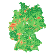
Degree of Urbanization - Germany, 2018
The degree of urbanization provides urbanization level information at 100x100 meter grids for Germany. It is based on population numbers, building density and the share of building types. It is provided as a continuous percentage value representing the probability of the degree of urbanization, as well as five discrete values representing classes of the degree of urbanization: definitely ‘urban’, probably ‘urban’, area of uncertainty, probably ‘rural’, definitely ‘rural’.
Simple
- Date (Creation)
- 2026-02-02T00:00:00
- Citation identifier
- https://geoservice.dlr.de/catalogue/srv/metadata/240d25e4-8c5a-4a9b-852d-3d38773545a2
- Presentation form
- Digital map
- Other citation details
-
DOI: 10.15489/rskmh269c925
- Purpose
-
More differentiated statistical analysis of space – target group, e.g., State Office for the Environment (LfU), DeStatis, Federal Office for Population Research, Federal Office for Building, Urban Planning, and Regional Development (BBSR), or similar institutions as well as researchers.
- Status
- Completed
- Maintenance and update frequency
- As needed
-
GEMET - INSPIRE themes, version 1.0
-
-
Land cover
-
Buildings
-
- Keywords
-
-
DLR
-
EOC
-
Degree of urbanization
-
urban
-
rural
-
spatial statistics
-
building density
-
population density
-
Germany
-
opendata
-
- Use limitation
-
Nutzungseinschränkungen: Das DLR ist nicht haftbar für Schäden, die sich aus der Nutzung ergeben. / Use Limitations: DLR not liable for damage resulting from use.
- Access constraints
- Other restrictions
- Use constraints
- Other restrictions
- Other constraints
-
Nutzungsbedingungen: Lizenz, https://creativecommons.org/licenses/by/4.0/ Terms of use: License, https://creativecommons.org/licenses/by/4.0/
- Other constraints
-
{"id": "cc-by-4.0",
"name": "Creative-Commons - Attribution 4.0 International (CC BY 4.0)",
"url": " http://dcat-ap.de/def/licenses/cc-by/4.0 ",
"quelle": "Copyright DLR (2026)"}
- Spatial representation type
- Grid
- Denominator
- 200000
- Language
- English
- Character set
- UTF8
- Topic category
-
- Society
))
- Begin date
- 2018-01-01T00:00:00
- End date
- 2018-12-31T23:59:59
- Unique resource identifier
- EPSG:3035 - ETRS89-extended / LAEA Europe
- Number of dimensions
- 2
- Dimension name
- Column
- Dimension size
- 6413
- Resolution
- 100 m
- Dimension name
- Row
- Dimension size
- 8675
- Resolution
- 100 m
- Cell geometry
- Area
- Transformation parameter availability
- No
- Distribution format
-
-
GeoTIFF
()
-
GeoTIFF
()
- OnLine resource
- HTTP download Degree of Urbanization Germany ( WWW:LINK-1.0-http--link )
- OnLine resource
- Scientific publication ( WWW:LINK-1.0-http--link )
- OnLine resource
- Scientific publication ( WWW:LINK-1.0-http--link )
- Hierarchy level
- Dataset
Domain consistency
- Measure identification
- INSPIRE / Conformity_001
Conformance result
- Date (Publication)
- 2010-12-08
- Explanation
-
See the referenced specification.
- Pass
- Yes
- Statement
-
(1) Administrative municipal units of Germany (BKG) (BKG, 2020). (2) Census data on the population in 100x100-meter grid cells (DeStatis, 2020). Here, we refer to population data from 2018. These were projected based on census data from 2011 to 2018. (3) Level of detail 1 (LoD-1): Official building models with information on floor space and building height (BKG, 2021), and (4) Data on definitions of the degree of urbanization from World Urbanization Prospects (UN, 2020)
- Description
-
Processing:The Degree of Urbanization was created based on 29 different urbanization layers, which reflect various definitions of urban space. Fifteen definitions are based on administrative interpretations of “urban space.” These definitions were applied to Germany from various countries around the world. The remaining 14 layers were generated using variable threshold values at the grid level. These define the degree of urbanization according to different thresholds (i.e. 1%, 25%, 50%, 75%, and 99%) based on different variables, such as the proportion of built-up area, the number of inhabitants, or the proportion of multi-family houses. These 29 layers were superimposed and intersected with each other across the entire study area to obtain a probability of the degree of urbanization.
Quality Assurance: The input data is comprehensive, largely consistent, and, compared to data sets from other large-scale studies on the degree of urbanization, offers unprecedented spatial and thematic resolution. Since the data sets originate from official databases, we are confident that errors are relatively minor and that our results are generally reliable. Nevertheless, they contain errors in terms of completeness, consistency, and accuracy. Due to the lack of better data sets, we cannot quantify this error here, which means that the impact on the degree of urbanization cannot be quantified.
- File identifier
- 240d25e4-8c5a-4a9b-852d-3d38773545a2 XML
- Metadata language
- English
- Character set
- UTF8
- Hierarchy level
- Dataset
- Hierarchy level name
-
Dataset
- Date stamp
- 2026-02-02T15:24:49
- Metadata standard name
-
ISO 19115-1:2014/19139
Overviews

Spatial extent
Provided by
