 My GeoNetwork catalogue
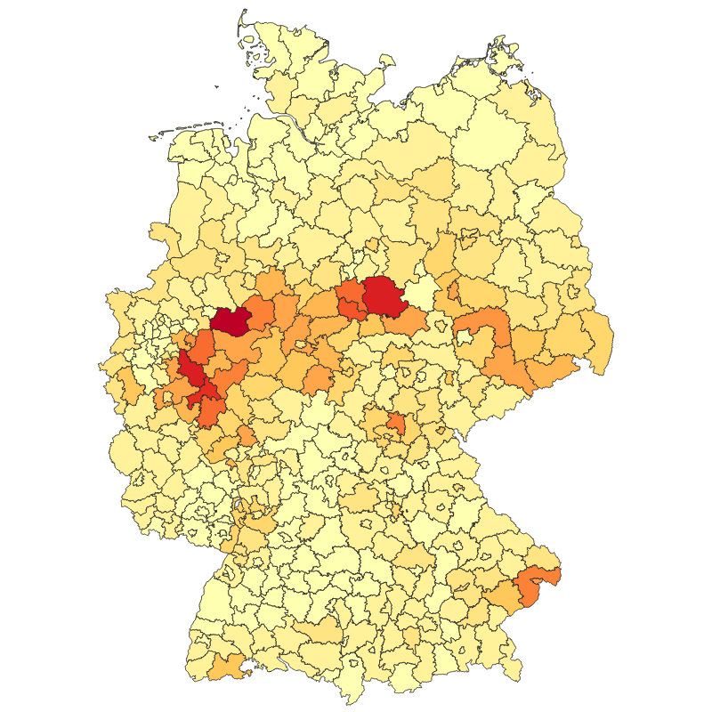
Tree Canopy Cover Loss Yearly per District - Germany, 2018-2021
The product contains information of tree canopy cover loss in Germany per district (Landkreis) between January 2018 and April 2021 at monthly temporal resolution. The information is aggregated at from the 10 m spatial resolution Sentinel-2 and Landsat-based raster product (Tree Canopy Cover Loss Monthly - Landsat-8/Sentinel-2 - Germany, 2018-2021). The method used to derive this product as well as the mapping results are described in detail in Thonfeld et al. (2022). The map depicts areas of natural disturbances (windthrow, fire, droughts, insect infestation) as well as sanitation and salvage logging, and regular forest harvest without explicitly differentiating these drivers. The vector files contain information about tree canopy cover loss area per forest type (deciduous, coniferous, both) and per year (2018, 2019, 2020, January-April 2021, and January 2018-April 2021) in absolute numbers and in percentages. In addition, the vector files contain the district area and the total forest area per district.
Simple
- Date (Creation)
- 2022-08-11T00:00:00
- Citation identifier
- https://geoservice.dlr.de/catalogue/srv/metadata/281e0d18-0ae0-449f-88ee-acab8626a77f
- Presentation form
- Digital map
- Purpose
-
This map shows the tree canopy cover losses in Germany per district from 2018 to 2021.
- Status
- Completed
- Maintenance and update frequency
- As needed
-
GEMET - INSPIRE themes, version 1.0
-
-
Land cover
-
- Keywords
-
-
opendata
-
Forest
-
Canopy Cover Loss
-
Drought
-
Disturbance Index
-
Sentinel-2
-
Landsat-8
-
Germany
-
- Use limitation
-
Nutzungseinschränkungen: Das DLR ist nicht haftbar für Schäden, die sich aus der Nutzung ergeben. / Use Limitations: DLR not liable for damage resulting from use.
- Access constraints
- Other restrictions
- Use constraints
- Other restrictions
- Other constraints
-
Nutzungsbedingungen: Lizenz, https://creativecommons.org/licenses/by/4.0/ Terms of use: License, https://creativecommons.org/licenses/by/4.0/
- Other constraints
-
{"id": "cc-by-4.0",
"name": "Creative-Commons - Attribution 4.0 International (CC BY 4.0)",
"url": " http://dcat-ap.de/def/licenses/cc-by/4.0 ",
"quelle": "Copyright DLR (2022)"}
- Spatial representation type
- Vector
- Denominator
- 20000
- Language
- English
- Character set
- UTF8
- Topic category
-
- Biota
))
- Begin date
- 2018-01-01T00:00:00
- End date
- 2021-04-30T23:59:59
- Unique resource identifier
- EPSG:3035 - ETRS89-extended / LAEA Europe
- Topology level
- Full surface graph
- Geometric object type
- Surface
- Geometric object count
- 403
- Distribution format
-
-
Shapefile
()
-
Geopackage
()
-
Shapefile
()
- OnLine resource
- EOC Geoservice Dataset ( WWW:LINK-1.0-http--link )
- OnLine resource
-
TREE_CANOPY_COVER_LOSS_HA_ALLFOREST_P1Y
(
OGC:WMS
)
WMS Access: Tree Canopy Cover Loss Germany per District for all forests in HA (2018-2021)
- OnLine resource
-
TREE_CANOPY_COVER_LOSS_HA_CONIFEROUS_P1Y
(
OGC:WMS
)
WMS Access: Per-District statistics of Coniferous Tree Canopy Cover Loss Germany in ha (2018-2021)
- OnLine resource
-
TREE_CANOPY_COVER_LOSS_HA_DECIDUOUS_P1Y
(
OGC:WMS
)
WMS Access: Per-District statistics of Deciduous Tree Canopy Cover Loss Germany in ha (2018-2021)
- OnLine resource
-
TREE_CANOPY_COVER_LOSS_PERC_ALLFOREST_P1Y
(
OGC:WMS
)
WMS Access: Tree Canopy Cover Loss Germany per District for all forests in % (2018-2021)
- OnLine resource
-
TREE_CANOPY_COVER_LOSS_PERC_CONIFEROUS_P1Y
(
OGC:WMS
)
WMS Access: Per-District statistics of Coniferous Tree Canopy Cover Loss Germany in ha (2018-2021)
- OnLine resource
-
TREE_CANOPY_COVER_LOSS_PERC_DECIDUOUS_P1Y
(
OGC:WMS
)
WMS Access: Per-District statistics of Deciduous Tree Canopy Cover Loss Germany in ha (2018-2021)
- OnLine resource
- HTTP download Tree Canopy Cover Loss Monthly - Germany, 2018-2021 ( WWW:LINK-1.0-http--link )
- OnLine resource
-
Sorge um den deutschen Wald
(
WWW:LINK-1.0-http--link
)
DLR News - Webpage
- Hierarchy level
- Dataset
Domain consistency
- Measure identification
- INSPIRE / Conformity_001
Conformance result
- Date (Publication)
- 2010-12-08
- Explanation
-
See the referenced specification.
- Pass
- Yes
- Statement
-
All Sentinel-2 and Landsat-8 data since 2017 available through the Google Earth Engine (GEE) with less than 80 % cloud cover were used.
- Description
-
Tree Canopy Cover Loss - Germany 2018-2021 - Processing
Processing:
The Sentinel-2 level 2 surface reflectance dataset available from GEE was processed using sen2cor and the Landsat-8 level 2 dataset is composed of surface reflectance data processed using the land surface reflectance code (LaSRC).
Quality Assurance:
With regard to the spatial accuracy, our assessment based on pixel counts revealed an overall accuracy of 92.8%. The sample-based accuracy assessment revealed an overall accuracy of 98% ± 1% and an area estimate of 643,735 ha ± 120,726 ha canopy cover loss. This map is a modified version of the paper, where we removed low-confidence losses, particularly during early 2018 and the 2020/21 winter.
- File identifier
- 281e0d18-0ae0-449f-88ee-acab8626a77f XML
- Metadata language
- English
- Character set
- UTF8
- Hierarchy level
- Dataset
- Hierarchy level name
-
Dataset
- Date stamp
- 2025-02-03T08:54:56
- Metadata standard name
-
ISO 19115-1:2014/19139
Overviews
Spatial extent
Provided by
