 My GeoNetwork catalogue
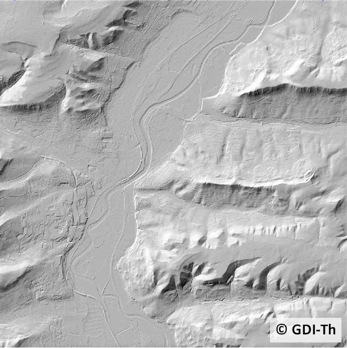
Digitales Geländemodell 25
Digitale Geländemodelle (DGM) beschreiben das Relief der Erdoberfläche durch ein regelmäßiges oder unregelmäßiges Punktraster, wobei für jeden Rasterpunkt die Lage und die Höhe bekannt sind. Es wird zwischen verschiedenen DGM je nach Höhengenauigkeit und Rasterweite unterschieden.
Simple
- Alternate title
-
Digitale Geländemodelle
- Date (Creation)
- 1996-01-01
- Citation identifier
- https://registry.gdi-de.org/id/de.th.csw/2ebce934-5b10-4741-aab9-81f094763f8e
- Status
- On going
+49 (361) 57-2176 450
https://tlbg.thueringen.de/
- Maintenance and update frequency
- Continual
- Keywords
-
-
Luftbild
-
entzerren
-
Gelände
-
Orthophoto
-
GOVE
-
Modell
-
AdVMIS
-
Airborne
-
Laserscanning
-
LIDAR
-
opendata
-
-
GEMET - INSPIRE themes, version 1.0
-
-
Höhe
-
- Access constraints
- Other restrictions
- Other constraints
- Es gelten keine Zugriffsbeschränkungen
- Use constraints
- Other restrictions
- Other constraints
-
Es gelten die Lizenzbedingungen „Datenlizenz Deutschland - Namensnennung - Version 2.0“ bzw. „dl-de/by-2-0” ( https://www.govdata.de/dl-de/by-2-0 ) mit den dort geforderten Angaben zum Quellenvermerk. Als Rechteinhaber und Bereitsteller ist die Datenhaltende Stelle, sowie das Jahr des Datenbezugs in Klammern anzugeben. Beispiel für Quellenvermerk: GDI-Th (2021) Datenlizenz Deutschland - Namensnennung - Version 2.0 (www.govdata.de/dl-de/by-2-0).
- Other constraints
-
{
"id": "dl-by-de/2.0",
"name": "Datenlizenz Deutschland Namensnennung 2.0",
"url": " https://www.govdata.de/dl-de/by-2-0 ",
"quelle": "© GDI-Th"
}
- Distance
- 2 m
- Language
- Deutsch
- Character set
- UTF8
- Topic category
-
- Elevation
- Description
-
Thüringen
))
- Reference system identifier
- http://www.epsg.org / EPSG:25832
- Distribution format
-
-
Koordinatentripel (Rechtswert, Hochwert, Höhe)
(
ASCII-Format
)
-
Koordinatentripel (Rechtswert, Hochwert, Höhe)
(
ASCII-Format
)
+49 361 57-4176 759
- OnLine resource
-
ThürVwKostOVerm
(
WWW:LINK-1.0-http--link
)
Thüringer Verwaltungskostenordnung für das amtliche Vermessungswesen (ThürVwKostOVerm)
- OnLine resource
- AGNB ( WWW:LINK-1.0-http--link )
- OnLine resource
-
WMS TH DGM
(
OGC:WMS-http-get-map
)
Geoproxy Thüringen WMS für AAA ATKIS (R) DGM
- OnLine resource
- Downloadbereich geoportal-th.de ( WWW:DOWNLOAD-1.0-http--download )
- Hierarchy level
- Dataset
Conformance result
- Alternate title
-
Digitale Geländemodelle
- Date (Creation)
- 1996-01-01
- Citation identifier
- 14418d25-fcd7-4a3f-99a9-e3059a2772af
- Explanation
-
landesweit flächendeckend vorhanden
- Pass
- Yes
- Statement
-
Im TLVermGeo wird seit 1996 zur Erfassung das Verfahren des Airborne Laserscanning eingesetzt.
- File identifier
- 2ebce934-5b10-4741-aab9-81f094763f8e XML
- Metadata language
- Deutsch
- Character set
- UTF8
- Hierarchy level
- Dataset
- Date stamp
- 2022-01-24T14:37:57
- Metadata standard name
-
ISO 19115/19119
+49 361 57-4176 799
https://tlbg.thueringen.de/
Overviews
Spatial extent
Provided by
