 My GeoNetwork catalogue
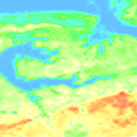
Helicopter-borne Radiometrics (HRD) Area 195 Ahlenmoor
BGR conducted an airborne survey in the region of the Ahlenmoor (Lower Saxony) as part of the BGR project D-AERO-Moore. Cunducting tests of their airborne system, the BGR surveys a portion of the Ahlenmoor with the BGR airborne geophysical standard measuring system. The peatland is located about 15 km northeast of the city of Bremerhaven close to Ahlen-Falkenberg. The size of the area is about 15 km². The area was surveyed with 2 flights totalling to 105 line-km (2,899 survey points). The nominal separation of the 16 WNW-ESE lines and 2 NNE-SSW tie lines was 125 m and 2000 m, respectively. The maps display the total count, the (equivalent) content of potassium, uranium and thorium as well as the exposure rate at ground.
Simple
- Alternate title
-
195AhlenmoorHRD
- Date (Publication)
- 2024-06-01
- Edition
-
1
- Citation identifier
- 38fb3090-ebb6-10a5-39ec-fca54609a281
- Citation identifier
- https://doi.org/10.25928/6zkc-vz47
- Status
- Completed
-
GEMET - INSPIRE themes, version 1.0
-
-
Geologie
-
Geology
-
-
GEMET - Concepts, version 2.4
-
-
Geophysik
-
- Theme
-
-
Aerogeophysik
-
Hubschrauber-Radiometrie
-
Äquivalentgehalte
-
Thorium
-
Uran
-
Kalium
-
Ionendosisleistung
-
Airborne geophysics
-
helicopter-borne radiometrics
-
equivalent concentrations
-
Uranium
-
Potassium
-
exposure rate
-
- Place
-
-
Niedersachsen
-
Ahlenmoor
-
- Access constraints
- Other restrictions
- Other constraints
- Es gelten keine Zugriffsbeschränkungen
- Use constraints
- Other restrictions
- Other constraints
-
Allgemeine Geschäftsbedingungen, siehe https://www.bgr.bund.de/AGB - General terms and conditions, see https://www.bgr.bund.de/AGB_en . Die bereitgestellten Informationen sind bei Weiterverwendung wie folgt zu zitieren: Datenquelle: 195AhlenmoorHRD, (c) BGR, Hannover, 2024, doi: 10.25928/6zkc-vz47
- Spatial representation type
- Grid
- Language
- Deutsch
- Character set
- UTF8
- Topic category
-
- Geoscientific information
))
- Unique resource identifier
- EPSG:25832
- Distribution format
-
-
georef. TIFF
(
n/a
)
-
PDF
(
n/a
)
-
georef. TIFF
(
n/a
)
- OnLine resource
-
195AhlenmoorHRD (georef. TIFF)
195AhlenmoorHRD im Format georef. TIFF
- OnLine resource
-
195AhlenmoorHRD (PDF)
195AhlenmoorHRD im Format Adobe Acrobat
- OnLine resource
- BGR-Website: Projekt D-AERO Moore
- OnLine resource
- Gebietsbericht Archiv-Nr. OASYS 208763
- OnLine resource
- Metadatenbeschreibung der Rohdaten
- Hierarchy level
- Dataset
Conformance result
- Date (Publication)
- 2010-12-08
- Explanation
-
siehe dazu die angegebene Durchführungsbestimmung
- Statement
-
BGR-Projekt "D-AERO-Moore: Untersuchung von Möglichkeiten für eine großflächige Moorerkundung"
- File identifier
- 33a02a18-9522-45e6-9471-dd3c7e101f48 XML
- Metadata language
- Deutsch
- Character set
- UTF8
- Parent identifier
-
Helicopter-borne Radiometrics (HRD)
ac818fce-f429-449c-85cf-6c838db1d0da
- Hierarchy level
- Dataset
- Hierarchy level name
-
Geophysik
- Date stamp
- 2026-01-13
- Metadata standard name
-
INSPIRE Metadata Implementing Rules: Technical Guidelines based on EN ISO 19115 and EN ISO 19119
- Metadata standard version
-
n/a
Overviews
Spatial extent
Provided by
