 My GeoNetwork catalogue
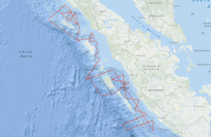
Processed seismic data of Cruise SO189 SUMATRA 2006
The SUMATRA cruise SO189 Leg 1, aboard the RV SONNE, was carried out off Sumatra between 3rd August and 3rd September 2006, with mobilisation in Penang, Malaysia and demobilisation in Jakarta, Indonesia, respectively. The survey was dedicated to marine geophysical measurements and acquired multichannel seismic data (MCS) using a 240 channel streamer, and a tuned airgun array comprising 16 airguns with a total capacity of 50.8 litres. Bathymetry data, using the 12 kHz Simrad swath system, sub-seabed data using the hull mounted high resolution PARASOUND profiler together with gravity (G) and magnetic (M) data were also acquired. Along two lines with a total length of ~ 390 km refraction/wide-angle seismic experiments were carried out. During the survey a total of 4,375 line kilometres of MCS, M and G data were acquired and an additional 990 km with M and G alone. The 41 MCS lines cover as close grid three fore-arc basins. Five lines extend nearly orthogonal to the subduction front and, thus, cover the whole subduction system from the adjacent oceanic plate, the trench and accretionary prism over the Outer Arc High to the forearm basins offshore Sumatra. The survey was planned using the bathymetry from the HMS SCOTT, RV NATSUSHIMA, RV MARION DUFRESNE and RV SONNE cruises carried out in 2004, 2005 and 2006. The main scientific objective of the project SUMATRA is to determine or estimate the hydrocarbon (HC) system (source rocks, HC generation, HC migration and reservoir rocks) of the Sumatra fore-arc region (mainly the fore-arc basins). Cruise SO189 Leg 1 was designed to investigate the architecture, sedimentary thickness, sedimentary evolution and subsidence history of the fore-arc basins Siberut, Nias and Simeulue off Sumatra. In the Simeulue Basin it was possible to connect the seismic lines to three industry wells and to correlate the seismic horizons to the results from the wells. The Simeulue Basin is divided into a northern and southern sub-basin. Carbonate build-ups were found in the northern sub-basin only on the very shallow shelf in the north-east. The maximum thickness was determined to be ~ 3 s TWT. In the southern sub-basin carbonate build-ups (which were already identified on some lines of the SEACAUSE project), bright spots and Bottom Simulating Reflectors (BSRs) are wide spread. The narrowest basin surveyed was the Nias Basin. As the Simeulue Basin the Nias Basin is divided into two sub-basins which are separated by a structural high. Although the basin has a maximum width of only 55 km the maximum sediment thickness exceeds 5 s TWT. The largest fore-arc basin is the Siberut Basin. It extends from the equator to ~ 5°S over 550 km and has a maximum width of 140 km between the island of Siberut and Sumatra. The maximum sediment thickness in this basin is 4.8 s TWT. The basin geometry is uniform along its axis. At the basins termination on the western side to the Outer Arc High the Mentawai Fault Zone could be traced. The geometry of this major fault changes significantly along strike. In some areas it is traceable as one single fold whereas in other areas it spreads in up to three different branches indicating splay faults originating from a main fault. In the Siberut Basin BSRs are very wide spread and very good recognizable over the Mentawai Fault Zone. Along the Mentawai Fault and along the eastern rim of the basin the seismic data show strong indications for active venting. The morphology of the Sunda Trench and its sedimentary cover varies from north to south. In the north the trench is poorly defined with shallow seabed dip but with sediment thickness of ~ 3.5 s TWT. The seafloor dips increase southwards, but sediment thickness decreases to ~ 2.5 s TWT off Nias. Both the ocean basin and trench sediments are dissected by numerous normal faults with a maximum displacement of 0.6 s TWT. Along strike the deformation front between Nias and Siberut displays several incipient folds. As offshore northern Sumatra, both landward (BGR06-228) and seaward verging folds (BGR06-227) are developed at the deformation front. For the first time landward verging folds have now been imaged in this domain of the Sunda subduction zone. In contrary to first thoughts during the expedition SO186-2 SEACAUSE, landward verging folds are not limited to the area off Aceh. Two refraction lines were acquired parallel to the subduction front at 2°30'N and 1°30'S approximately 40 - 50 km seaward of Simeulue and Siberut Island, respectively. The lines were designed to identify the segment boundaries in the subduction system as well as to detect and decipher the subducted aseismic Investigator Ridge. The gravity data set consists now of over 38,000 line km (combining the GINCO, SEACAUSE I and II and the SUMATRA data). With this it was possible to compile a map of the free-air gravity from the northern tip of Sumatra (~ 6°30'N/95°E) to Mid Java( ~8°30'S/110°E). Gravity modelling in parallel with refraction seismic data interpretation was carried along two lines during the cruise. The preliminary results show that the incoming oceanic plate is unusual thin both in the north off Simeulue (6 km) and in the south off Nias (5 km).
Simple
- Alternate title
-
SO189 SUMATRA 2006
- Date (Creation)
- 2006-09-03
- Citation identifier
- 22dead52-ac92-b5a8-697b-879fbe7d3f40
- Status
- Completed
-
GEMET - INSPIRE themes, version 1.0
-
-
Geologie
-
geology
-
-
GEMET - Concepts, version 2.4
-
-
geophysics
-
Geophysik
-
raw material
-
Rohstoff
-
- Theme
-
-
Marine geology
-
Meeresgeologie
-
Seismics
-
Seismik
-
Two-dimensional seismic reflection
-
zweidimensionale Reflektionsseismik
-
- Place
-
-
Indian Ocean
-
Sunda Arc
-
Indischer Ozean
-
Sundabogen
-
Sumatra
-
- Access constraints
- Other restrictions
- Other constraints
- Es gelten keine Zugriffsbeschränkungen
- Use constraints
- Other restrictions
- Other constraints
-
Allgemeine Geschäftsbedingungen, siehe http://www.bgr.bund.de/AGB - General terms and conditions, see http://www.bgr.bund.de/AGB_en . Die bereitgestellten Informationen sind bei Weiterverwendung wie folgt zu zitieren: Datenquelle: SO189 SUMATRA 2006, (c) BGR, Hannover, 2019
- Spatial representation type
- Vector
- Language
- English
- Character set
- UTF8
- Topic category
-
- Geoscientific information
))
- Unique resource identifier
- EPSG:4326
- Distribution format
-
-
Shapefile
(
n/a
)
-
Shapefile
(
n/a
)
- Transfer size
- 2
- OnLine resource
-
SO189 SUMATRA 2006 (Shapefile)
SO189 SUMATRA 2006 im Format ESRI Shape
- OnLine resource
- Profile BGR06-208
- OnLine resource
- Profile BGR06-208A
- OnLine resource
- Profile BGR06-209
- OnLine resource
- Profile BGR06-210
- OnLine resource
- Profile BGR06-211
- OnLine resource
- Profile BGR06-212
- OnLine resource
- Profile BGR06-213
- OnLine resource
- Profile BGR06-214
- OnLine resource
- Profile BGR06-214A
- OnLine resource
- Profile BGR06-215
- OnLine resource
- Profile BGR06-215A
- OnLine resource
- Profile BGR06-216
- OnLine resource
- Profile BGR06-217
- OnLine resource
- Profile BGR06-218
- OnLine resource
- Profile BGR06-219
- OnLine resource
- Profile BGR06-220
- OnLine resource
- Profile BGR06-221
- OnLine resource
- Profile BGR06-222
- OnLine resource
- Profile BGR06-222A
- OnLine resource
- Profile BGR06-222B
- OnLine resource
- Profile BGR06-223
- OnLine resource
- Profile BGR06-224
- OnLine resource
- Profile BGR06-225
- OnLine resource
- Profile BGR06-226
- OnLine resource
- Profile BGR06-227
- OnLine resource
- Profile BGR06-228
- OnLine resource
- Profile BGR06-229
- OnLine resource
- Profile BGR06-230
- OnLine resource
- Profile BGR06-231
- OnLine resource
- Profile BGR06-231A
- OnLine resource
- Profile BGR06-231B
- OnLine resource
- Profile BGR06-232
- OnLine resource
- Profile BGR06-233
- OnLine resource
- Profile BGR06-234
- OnLine resource
- Profile BGR06-235
- OnLine resource
- Profile BGR06-236
- OnLine resource
- Profile BGR06-237
- OnLine resource
- Profile BGR06-238
- OnLine resource
- Profile BGR06-239
- OnLine resource
- Profile BGR06-240
- OnLine resource
- Profile BGR06-240A
- OnLine resource
- Profile BGR06-241
- OnLine resource
- Profile BGR06-241A
- OnLine resource
- Karte im BGR-Geoviewer
- Hierarchy level
- Dataset
Conformance result
- Date (Publication)
- 2010-12-08
- Explanation
-
siehe dazu die angegebene Durchführungsbestimmung
- Statement
-
During the period from 3rd August to 3rd September 2006 BGR acquired seismic lines off Sumatra during leg 1 of cruise SO189 with RV SONNE. The lines BGR06-214A, BGR06-215, BGR06-222A and BGR06-231A are stacked data. The lines BGR06-208, BGR06-208A, BGR06-209, BGR06-210, BGR06-211, BGR06-212, BGR06-213, BGR06-214, BGR06-215A, BGR06-216, BGR06-217, BGR06-218, BGR06-219, BGR06-220, BGR06-221, BGR06-222, BGR06-222B, BGR06-223, BGR06-224, BGR06-225, BGR06-226, BGR06-227, BGR06-228, BGR06-229, BGR06-230, BGR06-231, BGR06-231B, BGR06-232, BGR06-233, BGR06-234, BGR06-235, BGR06-236, BGR06-237, BGR06-238, BGR06-239, BGR06-240, BGR06-240A, BGR06-241 and BGR06-241A are migrated data.
- File identifier
- 43851906-dbff-464e-bb6e-66973dc7e48c XML
- Metadata language
- English
- Character set
- UTF8
- Parent identifier
-
Marine Seismic Survey Profiles (MSSP)
06a73c56-06a2-40d8-b806-466222b0760d
- Hierarchy level
- Dataset
- Hierarchy level name
-
Geophysik
- Date stamp
- 2023-11-16
- Metadata standard name
-
INSPIRE Metadata Implementing Rules: Technical Guidelines based on EN ISO 19115 and EN ISO 19119
- Metadata standard version
-
n/a
Overviews
Spatial extent
Provided by
