 My GeoNetwork catalogue
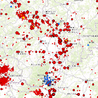
German Earthquake Catalogue
This Web Map Service (WMS) is based on a database providing information on the seismicity in Germany an adjacent areas. It contains locations of seismic events since 800; whereat their epicentre determinations are based on historical sources as well as on measurements of seismometer stations since the start of instrumental seismological recording in the 20th century. Today, digital data acquisition at seismometer stations of the German regional seismic network (GRSN), the seismic GERES array, and the Gräfenberg array (GRF),enables along with near real time data transmission of recorded seismometer data to the seismological central observatory at BGR, the immediate detection and analysis of seismic events, and their provision to the WMS. All events with a local magnitude ML 2.0 and higher are shown. The epicentre determination is initially carried out by an automatic processing procedure. Such a procedure might result - occasionally - inerroneous epicentre estimates and overestimated magnitudes. Therefore results obtained by the automatic procedure routinely post-processed by a manual and inter-active analysis on the following labour day.
Simple
- Alternate title
-
GERSEIS
- Date (Revision)
- 2016-04-01
- Citation identifier
- F353B6D7-3BAA-4D31-8913-F7D19A340BC3
- Status
- On going
-
GEMET - INSPIRE themes, version 1.0
-
-
Gebiete mit naturbedingten Risiken
-
-
GEMET - Concepts, version 2.4
-
-
Seismische Überwachung
-
-
GGA-Liste
-
-
Seismologie
-
- Theme
-
-
Epizentrum
-
Erdbeben
-
Induzierte Seismizität
-
Tektonik
-
- Place
-
-
Deutschland und angrenzende Gebiete
-
- Keywords
-
-
opendata
-
-
High-value dataset categories
-
-
Erdbeobachtung und Umwelt
-
- Access constraints
- Other restrictions
- Other constraints
- Es gelten keine Zugriffsbeschränkungen
- Use constraints
- Other restrictions
- Other constraints
-
Allgemeine Geschäftsbedingungen, siehe https://www.bgr.bund.de/AGB - General terms and conditions, see https://www.bgr.bund.de/AGB_en . Die bereitgestellten Informationen sind bei Weiterverwendung wie folgt zu zitieren: Datenquelle: Deutscher Erdbebenkatalog,(C) BGR, Hannover, 2012
- Other constraints
-
Dieser Datensatz kann gemäß der "Nutzungsbestimmungen für die Bereitstellung von Geodaten des Bundes" ( https://sg.geodatenzentrum.de/web_public/gdz/lizenz/geonutzv.pdf ) genutzt werden.
- Other constraints
-
{"id": "geoNutz/20130319", "name": "Nutzungsbestimmungen für die Bereitstellung von Geodaten des Bundes", "url": " https://sg.geodatenzentrum.de/web_public/gdz/lizenz/geonutzv.pdf ", "quelle": "Deutscher Erdbebenkatalog,(C) BGR, Hannover, 2012"}
- Spatial representation type
- Vector
- Language
- Deutsch
- Character set
- UTF8
- Topic category
-
- Geoscientific information
))
- Geographic identifier
- Regionalschlüssel / 000000000000
- Unique resource identifier
- EPSG:4326
- Distribution format
-
-
Shapefile
(
n/a
)
-
Shapefile
(
n/a
)
- Transfer size
- 2
- OnLine resource
-
GERSEIS (Shapefile)
GERSEIS im Format ESRI Shape
- OnLine resource
- BGR-Webseite
- OnLine resource
- Karte im BGR-Geoviewer
- Hierarchy level
- Dataset
Conformance result
- Date (Publication)
- 2010-12-08
- Explanation
-
siehe dazu die angegebene Durchführungsbestimmung
- Statement
-
An seismischen Überwachungsstationen aufgezeichnete und ausgewertete Daten.
- File identifier
- 572FF5BD-EA1A-4BE4-9C7C-9F9CF6EC351B XML
- Metadata language
- Deutsch
- Character set
- UTF8
- Hierarchy level
- Dataset
- Hierarchy level name
-
Geophysik
- Date stamp
- 2026-01-13
- Metadata standard name
-
INSPIRE Metadata Implementing Rules: Technical Guidelines based on EN ISO 19115 and EN ISO 19119
- Metadata standard version
-
n/a
Overviews
Spatial extent
Provided by
