 My GeoNetwork catalogue
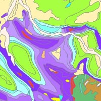
Geological Map of Germany 1:1,000,000 OneGeology-Europe (GK1000-1GE)
The “Geological Map of Germany 1:1,000,000 OneGeology-Europe (GK1000-1GE)” shows Germany’s surface geology: All geological units are described by their age (stratigraphy) and composition (lithology). The geological units and terms used in this map were semantically harmonized within the OneGeology-Europe project and have been - in a number of regions - geometrically and semantically made consistent with the neighbouring OneGeology-Europe participants.
Simple
- Alternate title
-
GK1000-1GE
- Date (Creation)
- 2018-05-02
- Date (Revision)
- 2018-06-07
- Citation identifier
- 736254e8-2a7e-49bc-bdee-4d8158a444cb
- Status
- Completed
-
GEMET - INSPIRE themes, version 1.0
-
-
Geology
-
Geologie
-
-
GEMET - Concepts, version 2.4
-
-
Earth science
-
Geowissenschaft
-
- Theme
-
-
OneGeology
-
OneGeology-Europe
-
EGDI
-
Bedrock
-
Anstehendes Gestein
-
Superficial deposits
-
Oberflächenablagerung
-
Surface geology
-
Oberflächengeologie
-
Petrology
-
Petrologie
-
Lithology
-
Lithologie
-
Stratigraphy
-
Stratigraphie
-
Harmonized geology
-
Harmonisierte Geologie
-
Harmonized age
-
Harmonisiertes Alter
-
Harmonized data
-
Harmonisierte Daten
-
- Place
-
-
Germany
-
Deutschland
-
- Access constraints
- Other restrictions
- Other constraints
- Es gelten keine Zugriffsbeschränkungen
- Use constraints
- Other restrictions
- Other constraints
-
General Terms and Conditions, s. https://www.bgr.bund.de/agb_en - Allgemeine Geschäftsbedingungen, s. https://www.bgr.bund.de/agb - In case of reuse the information provided should be cited as follows: "Data Source: OneGeology-Europe harmonized geology, (c) BGR Hanover, 2018"
- Spatial representation type
- Vector
- Denominator
- 1000000
- Language
- English
- Character set
- UTF8
- Topic category
-
- Geoscientific information
))
- Geographic identifier
- Regionalschlüssel / 000000000000
- Unique resource identifier
- EPSG:3034
- Distribution format
-
-
Shapefile
(
n/a
)
-
Shapefile
(
n/a
)
- Transfer size
- 22
- OnLine resource
-
GK1000-1GE (Shapefile)
GK1000-1GE im Format ESRI Shape
- OnLine resource
- Website of subdivision B4.2 Geological Information
- OnLine resource
- Webpage of the Geological Map of Germany 1 : 1,000,000 (GK1000)
- OnLine resource
- Webpage of the OneGeology project on the BGR Website
- Hierarchy level
- Dataset
Conformance result
- Date (Publication)
- 2010-12-08
- Explanation
-
See the referenced specification
- Statement
-
This dataset is based on the Geological Map of Germany 1:1,000,000 (GK1000).
- File identifier
- 5f77d681-b7e4-4dd0-8f15-7b93744450b0 XML
- Metadata language
- English
- Character set
- UTF8
- Hierarchy level
- Dataset
- Hierarchy level name
-
Geologie
- Date stamp
- 2026-01-13
- Metadata standard name
-
INSPIRE Metadata Implementing Rules: Technical Guidelines based on EN ISO 19115 and EN ISO 19119
- Metadata standard version
-
n/a
Overviews
Spatial extent
Provided by
