My GeoNetwork catalogue
Database of the Soil Map of the Federal Republic of Germany 1:250,000
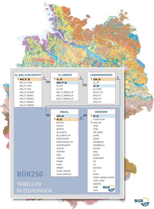
The new 1.0 version of the Soil Map 1:250,000 (BUEK250) database has its origins in the provisional BUEK200 database (version 0.8), which was developed in cooperation with the State Geological Surveys (SGD) of the federal states. It contains the pedological information of the 2171 legend units of the BUEK250, which can be linked to the areas of the graphic dataset of the BUEK250 via the GEN_ID data field. All the profile and horizon data of the dominant and associated soils are assigned to these legend units. Accordingly, thematic evaluations are carried out using the data fields of the corresponding database tables PROFILE and HORIZONT. The LEGENDENEINHEIT table contains, among other things, the textual descriptions of the BUEK250 legend units. Two additional tables (GL_EINHEIT, GL_BAG_FLAECHENTYP) can be used to assign the legend units to general legend units and to hierarchically structured surface types of the soil parent material.
Simple
- Alternate title
-
BÜK250-DB
- Date (Publication)
- 2024-11-22
- Edition
-
1.0
- Citation identifier
- 6F18E565-22DB-4D2E-895E-32D1495D3AC3
- Citation identifier
- https://doi.org/10.25928/BUEK250-DB_1.0
- Other citation details
-
BGR (2024): Datenbank der Bodenübersichtskarte der Bundesrepublik Deutschland 1:250.000, Hannover, DOI:10.25928/BUEK250-DB_1.0
- Status
- Completed
-
GEMET - INSPIRE themes, version 1.0
-
-
Boden
-
Soil
-
-
GEMET - Concepts, version 2.4
-
-
Bodenfeuchtigkeit
-
Bodenart
-
Bodenkarte
-
Bodenfunktion
-
Bodenbelastung
-
Bodenfruchtbarkeit
-
Bodennutzung
-
Bodenverbreitung
-
Bodenhorizont
-
Bodeneigenschaften
-
-
Freies Schlagwort
-
-
Bodengesellschaft
-
Bodensubstrat
-
Bodenprofil
-
Bodentyp
-
Bodenform
-
Bodensystematik
-
Bodenausgangsgestein
-
- Place
-
-
Bundesrepublik Deutschland
-
- Keywords
-
-
opendata
-
- Access constraints
- Other restrictions
- Other constraints
- Es gelten keine Zugriffsbeschränkungen
- Use constraints
- Other restrictions
- Other constraints
-
Allgemeine Geschäftsbedingungen, siehe http://www.bgr.bund.de/AGB - General terms and conditions, see http://www.bgr.bund.de/AGB_en . Die bereitgestellten Informationen sind bei Weiterverwendung wie folgt zu zitieren: Datenquelle: BÜK250-Datenbank V1.0, © BGR, Hannover, 2024.
- Other constraints
-
Dieser Datensatz kann gemäß der "Nutzungsbestimmungen für die Bereitstellung von Geodaten des Bundes" ( https://sg.geodatenzentrum.de/web_public/gdz/lizenz/geonutzv.pdf ) genutzt werden.
- Other constraints
-
{"id": "geoNutz/20130319", "name": "Nutzungsbestimmungen für die Bereitstellung von Geodaten des Bundes", "url": " https://sg.geodatenzentrum.de/web_public/gdz/lizenz/geonutzv.pdf ", "quelle": "BÜK250-Datenbank V1.0, © BGR, Hannover, 2024"}
- Spatial representation type
- Text, table
- Language
- Deutsch
- Character set
- UTF8
- Topic category
-
- Geoscientific information
- Geographic identifier
- Regionalschlüssel / 000000000000
- Unique resource identifier
- EPSG:25832
- Distribution format
-
-
MS Access
(
n/a
)
-
SQLite
(
n/a
)
-
MS Access
(
n/a
)
- OnLine resource
-
DB zur BÜK250 (Access)
Datenbank zur BÜK250 im Format MS Access
- OnLine resource
- BÜK250-Internetseite - BÜK250-Website
- OnLine resource
- BÜK250
- OnLine resource
-
DB zur BÜK250 (SQLite)
Datenbank zur BÜK250 im Format SQLite
- Hierarchy level
- Dataset
Conformance result
- Date (Publication)
- 2010-12-08
- Explanation
-
siehe dazu die angegebene Durchführungsbestimmung
- Statement
-
Vorläufige Sachdatenbank der Bodenübersichtskarte 1:200.000 (BÜK200), Version 0.8.
- File identifier
- 6178e5a0-45d1-410b-9bd9-e5104d865899 XML
- Metadata language
- Deutsch
- Character set
- UTF8
- Hierarchy level
- Dataset
- Hierarchy level name
-
Boden
- Date stamp
- 2025-08-21
- Metadata standard name
-
INSPIRE Metadata Implementing Rules: Technical Guidelines based on EN ISO 19115 and EN ISO 19119
- Metadata standard version
-
n/a