 My GeoNetwork catalogue
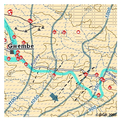
Hydrogeological Map of Zambia "Lusaka Province and Southern Province" (HYGMAP Zambia) 1:250,000/1:100,000
Zambia faces an increasing demand of industrial- and drinking water. In the field Zambia faces an increasing demand of industrial- and drinking water. In the fields of water supply and management, the Zambian government cooperates with BGR as one of the implementing agencies of the German Development Cooperation and other partners. The project "Groundwater Resources for Southern Province" aims at solutions for the southern parts of the country in which surface water is scarce and only temporarily available. Accurate and updated information about quality and quantity on both surface and groundwater resources is required to regulate its use and to establish an integrated and sustainable management of the Nation’s water resources. One result of data research is reflected in the GIS-based Hydrogeological Map "Southern Kariba Lake and Kalomo", scale 1:250,000.
Simple
- Alternate title
-
HYGMAP ZAMBIA (Serie)
- Date (Creation)
- 2007-12-31
- Edition
-
1. Auflage 2007
- Citation identifier
- 64665753-8BDA-47BC-B235-D948EECB3A82
- Other citation details
-
Größe der gedruckte Karte: 115,0 x 76,0 cm - Size of printed map: 115.0 x 76.0 cm
- Status
- Completed
-
GEMET - INSPIRE themes, version 1.0
-
-
Geologie
-
Geology
-
-
GEMET - Concepts, version 2.4
-
-
Groundwater
-
Grundwasser
-
Hydrogeologie
-
Hydrogeology
-
- Theme
-
-
Groundwater resources
-
Grundwasserressourcen
-
- Place
-
-
Sambia
-
- Place
-
-
Südprovinz
-
- Access constraints
- Other restrictions
- Other constraints
- Es gelten keine Zugriffsbeschränkungen
- Use constraints
- Other restrictions
- Other constraints
-
Allgemeine Geschäftsbedingungen, s. https://www.bgr.bund.de/agb - General Terms and Conditions, s. https://www.bgr.bund.de/agb_en
- Spatial representation type
- Grid
- Denominator
- 250000
- Language
- English
- Character set
- UTF8
- Topic category
-
- Geoscientific information
))
- Unique resource identifier
- EPSG:20935
- Unique resource identifier
- EPSG:4326
- Distribution format
-
-
pdf
(
n/a
)
-
jpg
(
n/a
)
-
pdf
(
n/a
)
- OnLine resource
- Indexkarte
- Hierarchy level
- Series
- Statement
-
Topograph. Karten 1:250.000, 1973-1992, Surveyor-General Lusaka; DEM, abgeleitet von SRTM-Daten, 2002; Geol. Karten 1:100.000, 1:250.000, 1:1.000.000, Geological Survey Department Lusaka; Grundwasser-Datenbank, Department of Water Affairs Lusaka, 2007 - Topographic Maps 1:250,000, 1973-1992, Surveyor-General, Lusaka; DEM, based on SRTM-data, 2002; Geological Maps 1:100,000, 1:250,000, 1:1,000,000, Geological Survey Department, Lusaka; Groundwater Database, Department of Water Affairs, Lusaka; 2007
- File identifier
- 65E979BD-0739-47FB-BDBA-006F10CF08D8 XML
- Metadata language
- Deutsch
- Character set
- UTF8
- Hierarchy level
- Series
- Hierarchy level name
-
Geologie
- Hierarchy level name
-
Grundwasser
- Date stamp
- 2026-01-13
- Metadata standard name
-
INSPIRE Metadata Implementing Rules: Technical Guidelines based on EN ISO 19115 and EN ISO 19119
- Metadata standard version
-
n/a
Overviews
Spatial extent
Provided by
