My GeoNetwork catalogue
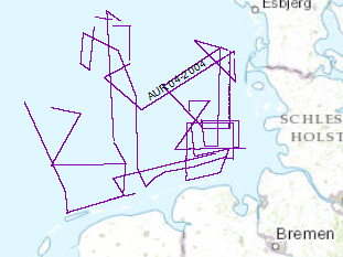
Prozessierte seismische Daten der Fahrt AUR 2004
Zur Erkundung der Entwicklung der deutschen ausschließlichen Wirtschaftszone im Tertiär und im Quartär wurden in der Zeit vom 31.05.2004 bis 19.06.2004 seismische Vermessungen mit FS Aurelia vorgenommen. In dieser Zeit wurden 2618 km hochauflösender Mehrkanalseismik (Format SEG-Y) aufgenommen. Dieses Projekt steht in enger Verbindung zu dem Datensatz der im September/Oktober 2003 mit FS Aurelia aufgenommen wurde.
Simple
- Alternativtitel
-
AUR04 2004
- Datumsangaben (Erstellung)
- 2003-06-19
- Identifikator
- 9758be03-e9e8-4cf4-aa2f-23e1e6cd6299
- Bearbeitungsstatus
- Abgeschlossen
-
GEMET - INSPIRE themes, version 1.0
-
-
geology
-
Geologie
-
-
GEMET - Concepts, version 2.4
-
-
marine geology
-
Meeresgeologie
-
geophysics
-
Geophysik
-
raw material
-
Rohstoff
-
- Thema
-
-
seismics
-
Seismik
-
two-dimensional seismic reflection
-
zweidimensionale Reflektionsseismik
-
MSSP
-
GeolDG
-
- Ort
-
-
North Sea
-
Nordsee
-
German EEZ
-
Deutsche AWZ
-
- Zugriffseinschränkungen
- Benutzerdefinierte Einschränkungen
- Andere Einschränkungen
- Es gelten keine Zugriffsbeschränkungen
- Nutzungseinschränkungen
- Benutzerdefinierte Einschränkungen
- Andere Einschränkungen
-
Allgemeine Geschäftsbedingungen, siehe https://www.bgr.bund.de/AGB - General terms and conditions, see https://www.bgr.bund.de/AGB_en . Die bereitgestellten Informationen sind bei Weiterverwendung wie folgt zu zitieren: Datenquelle: AUR04, (c) BGR, Hannover, 2004
- Räumliche Darstellungsart
- Vektor
- Sprache
- English
- Zeichensatz
- Utf8
- Thematik
-
- Geowissenschaften
))
- Code
- EPSG:4326
- Abgabeformat
-
-
Shapefile
(
n/a
)
-
Shapefile
(
n/a
)
- Transfergrösse
- 3
- Online
-
AUR04 2004 (Shapefile)
AUR04 2004 im Format ESRI Shape
- Online
- Profile AUR04-01
- Online
- Profile AUR04-02
- Online
- Profile AUR04-03
- Online
- Profile AUR04-04
- Online
- Profile AUR04-05
- Online
- Profile AUR04-5A
- Online
- Profile AUR04-06
- Online
- Profile AUR04-07
- Online
- Profile AUR04-08
- Online
- Profile AUR04-09
- Online
- Profile AUR04-10
- Online
- Profile AUR04-11
- Online
- Profile AUR04-12
- Online
- Profile AUR04-13
- Online
- Profile AUR04-14
- Online
- Profile AUR04-15
- Online
- Profile AUR04-16
- Online
- Profile AUR04-17
- Online
- Profile AUR04-18
- Online
- Profile AUR04-19
- Online
- Profile AUR04-20
- Online
- Profile AUR04-21
- Online
- Profile AUR04-22
- Online
- Profile AUR04-23
- Online
- Profile AUR04-24
- Online
- Profile AUR04-25
- Online
- Profile AUR04-26
- Online
- Profile AUR04-27
- Online
- Profile AUR04-27A
- Online
- Profile AUR04-28
- Online
- Profile AUR04-29
- Online
- Profile AUR04-30
- Online
- Profile AUR04-31
- Online
- Profile AUR04-32
- Online
- Profile AUR04-33
- Online
- Profile AUR04-34
- Online
- Profile AUR04-35
- Online
- Profile AUR04-36
- Online
- Profile AUR04-37
- Online
- Profile AUR04-37A
- Online
- Profile AUR04-38
- Online
- Profile AUR04-39
- Online
- Profile AUR04-40
- Online
- Profile AUR04-40A
- Online
- Profile AUR04-41
- Online
- Profile AUR04-42
- Online
- Profile AUR04-43
- Online
- Profile AUR04-44
- Online
- Profile AUR04-45
- Online
- Profile AUR04-46
- Online
- Profile AUR04-47
- Online
- Profile AUR04-48
- Online
- Karte im BGR-Geoviewer
- Bezugsebene
- Datenbestand
Konformitätsergebnis
- Datumsangaben (Publikation)
- 2010-12-08
- Erklärung
-
siehe dazu die angegebene Durchführungsbestimmung
- Erläuterung
-
During the period from 31st May to 19th of June 2004 BGR acquired seismic lines in the North Sea. The Lines AUR04-01, AUR04-02, AUR04-03, AUR04-04, AUR04-06, AUR04-07, AUR04-08, AUR04-09, AUR04-10, AUR04-11, AUR04-12, AUR04-13, AUR04-14, AUR04-15, AUR04-16, AUR04-17, AUR04-18, AUR04-19, AUR04-20, AUR04-21, AUR04-22, AUR04-23, AUR04-24, AUR04-25, AUR04-26, AUR04-27, AUR04-27A, AUR04-28, AUR04-29, AUR04-30, AUR04-31, AUR04-32, AUR04-33, AUR04-34, AUR04-35, AUR04-36, AUR04-37, AUR04-37A, AUR04-38, AUR04-39, AUR04-40, AUR04-40A, AUR04-41, AUR04-42, AUR04-43, AUR04-44, AUR04-45, AUR04-46, AUR04-47, AUR04-48 are processed (migrated) at BGR, whereas AUR04-05, AUR04-05A are raw data.
- Metadatensatzidentifikator
- 665c5507-08dc-416f-8296-9991f5cd8814 XML
- Sprache
- English
- Zeichensatz
- Utf8
- Identifikator des übergeordneten Metadatensatzes
-
Marine Seismic Survey Profiles (MSSP)
06a73c56-06a2-40d8-b806-466222b0760d
- Hierarchieebene
- Datenbestand
- Bezeichnung der Hierarchieebene
-
Geophysik
- Bezeichnung der Hierarchieebene
-
GeolDG
- Datum
- 2025-04-07
- Bezeichnung des Metadatenstandards
-
INSPIRE Metadata Implementing Rules: Technical Guidelines based on EN ISO 19115 and EN ISO 19119
- Version des Metadatenstandards
-
n/a