 My GeoNetwork catalogue
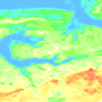
Helicopter-borne Radiometrics (HRD) German North Sea coast
This dataset has been compiled within the BGR project "D-AERO-Auswertung" based on several survey area located along the German North Sea coast. The BGR helicopter (Sikorsky S-76B) is used for airborne geophysical surveying of the Earth’s subsurface. The standard equipment comprises the methods electromagnetics, magnetics and radiometrics. The passive radiometric (HRD) system is installed into the helicopter and consists of a gamma-ray spectrometer with five Sodiumiodid detectors to measure the gamma radiation. The results are as maps displaying total count, exposure rate as well as (equivalent) concentrations of Potassium, Thorium and Uranium at ground level.
Simple
- Alternate title
-
NordseekuesteHRD
- Date (Publication)
- 2017-02-23
- Citation identifier
- 4039a969-1676-4810-b70c-f35af0334de8
- Citation identifier
- http://doi.org/10.25928/bgr2017hrd_tbtd-d240
- Status
- On going
-
GEMET - INSPIRE themes, version 1.0
-
-
Geologie
-
Geology
-
-
GEMET - Concepts, version 2.4
-
-
Geophysik
-
- Theme
-
-
Aerogeophysik
-
Hubschrauber-Radiometrie
-
Äquivalentgehalte
-
Thorium
-
Uran
-
Kalium
-
Ionendosisleistung
-
Airborne geophysics
-
helicopter-borne radiometrics
-
equivalent concentrations
-
Uranium
-
Potassium
-
exposure rate
-
- Place
-
-
Deutschland
-
- Access constraints
- Other restrictions
- Other constraints
- Es gelten keine Zugriffsbeschränkungen
- Use constraints
- Other restrictions
- Other constraints
-
Allgemeine Geschäftsbedingungen, siehe https://www.bgr.bund.de/AGB - General terms and conditions, see https://www.bgr.bund.de/AGB_en . Die bereitgestellten Informationen sind bei Weiterverwendung wie folgt zu zitieren: Datenquelle: NordseekuesteHRD, (c) BGR, Hannover, 2017, doi:10.25928/bgr2017hrd_tbtd-d240
- Spatial representation type
- Grid
- Language
- Deutsch
- Character set
- UTF8
- Topic category
-
- Geoscientific information
))
- Unique resource identifier
- EPSG:25832
- Distribution format
-
-
georef. TIFF
(
n/a
)
-
georef. TIFF
(
n/a
)
- Transfer size
- 7
- OnLine resource
-
NordseekuesteHRD (georef. TIFF)
NordseekuesteHRD im Format georef. TIFF
- OnLine resource
- BGR-Website: Aeroradiometrie
- OnLine resource
- BGR-Website: Projekt D-AERO
- OnLine resource
- Karte im BGR-Geoviewer
- Hierarchy level
- Dataset
Conformance result
- Date (Publication)
- 2010-12-08
- Explanation
-
siehe dazu die angegebene Durchführungsbestimmung
- Statement
-
Zusammenstellung im Rahmen des BGR-Projektes "D-AERO-Auswertung": Messgebiete: 081_Cuxhaven (2000), 087_Bremerhaven (2001), 109_Hadelner Marsch (2004), 111_Ellerbeker Rinne (2005/2006), 128_Langeoog (2008/2009), 129_Esens (2008/2009), 132_Glückstadt (2008/2009), 138_Nordenham (2009/2010), 133_Jever (2014), 139_Varel (2014)
- File identifier
- 6bfdf09b-f3d6-493a-8914-89ccdb006dd0 XML
- Metadata language
- Deutsch
- Character set
- UTF8
- Parent identifier
-
Helicopter-borne Radiometrics (HRD)
ac818fce-f429-449c-85cf-6c838db1d0da
- Hierarchy level
- Dataset
- Hierarchy level name
-
Geophysik
- Date stamp
- 2026-01-13
- Metadata standard name
-
INSPIRE Metadata Implementing Rules: Technical Guidelines based on EN ISO 19115 and EN ISO 19119
- Metadata standard version
-
n/a
Overviews
Spatial extent
Provided by
