 My GeoNetwork catalogue
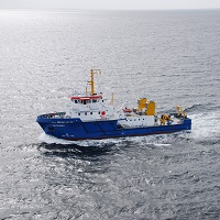
Schiffsausfahrt Hai22VE1
Messfahrt mit der MS Haithabu zur Erfassung von Meeresbodenstrukturen im Bereich des Stollergrunds (Kieler Bucht).
Eingesetzte Geräte: Seitensichtsonar (EA400), Kamera (Mini-Observer).
Simple
- Alternate title
-
Hai22VE1
- Date (Revision)
- 2022-05-18T00:00:00.000+02:00
- Citation identifier
- http://portalu.de/igc/234b98b2-950d-40e5-938d-eae2a9351358
- Purpose
-
Habitatmonitoring
- Status
- Completed
+49 (0) 04347 704-402
+49 4347 704-402
- Keywords
-
-
Rohdaten
-
Habitatkartierung
-
Seitensichtsonar
-
Videodaten
-
Video
-
msrl
-
ffh
-
MDI-DE
-
-
UMTHES Thesaurus
- Use constraints
- Other restrictions
- Other constraints
-
Datenlizenz Deutschland Namensnennung 2.0
- Other constraints
-
Quellenvermerk: LLUR SH
- Other constraints
-
{"id":"dl-by-de/2.0","name":"Datenlizenz Deutschland Namensnennung 2.0","url":" https://www.govdata.de/dl-de/by-2-0","quelle":"LLUR SH"}
- Language
- Deutsch
- Topic category
-
- Oceans
- Environment
- Extent type code
- Yes
- Geographic identifier
- Schleswig-Holstein (01)
))
- Code
- 010000000000
- Begin date
- 2022-04-25T00:00:00.000+02:00
- End date
- 2022-05-05T00:00:00.000+02:00
- Unique resource identifier
- EPSG 4326: WGS 84 / geographisch
- Distribution format
-
-
CSV
()
-
AVI
()
-
CSV
()
- OnLine resource
- Monitoring Handbuch
- Hierarchy level
- Dataset
- Statement
-
MSRL Monitoring Handbuch
Content Information
Content Information
Content Information
Content Information
Content Information
- File identifier
- 79835338-3212-4996-843E-91B63B1D69DE XML
- Metadata language
- Deutsch
- Character set
- UTF8
- Hierarchy level
- Dataset
- Date stamp
- 2026-02-25
- Metadata standard name
-
ISO19115
- Metadata standard version
-
2003/Cor.1:2006
+49 (0) 04347 704-402
Overviews
Spatial extent
Provided by
