 My GeoNetwork catalogue
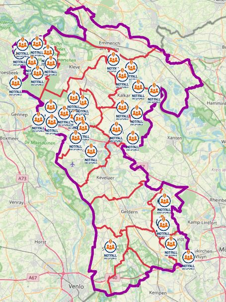
Notfall-Infopunkte Kreis Kleve
In der Rangfolge unterhalb der Leuchttürme sind so genannte "Notfall-Infopunkte" in der Fläche eingerichtet.
An Notfall-Infopunkten können sich die Bürgerinnen und Bürger informieren. Die personelle Besetzung und die Ausstattung sind jedoch nicht so umfangreich wie in den Leuchttürmen. Zum Teil erfolgt die Information auch ausschließlich über den Aushang in Bekanntmachungskästen o.ä.. Kommunen, die Leuchttürme in allen Ortschaften ausweisen, verzichten zum Teil auf die Benennung weiter Notfall-Infopunkte.
Teilweise können an den Notfall-Infopunkten auch Notrufe abgesetzt werden. An Bekanntmachungskästen ist dies nicht möglich.
Es handelt sich um keine dauerhafte Einrichtungen und werden von den Städten und Gemeinden bei Bedarf im Fall eines Notfalls besetzt.
Simple
- Date (Publication)
- 2023-06-30T00:00:00.000+02:00
- Citation identifier
- https://registry.gdi-de.org/id/de.nw/c4c916ae-2989-4cc9-9871-2f9670462ee7
+49 2821 85-500
https://www.kreis-kleve.de
- Maintenance and update frequency
- As needed
- Update scope
- Dataset
- Keywords
-
-
Kreis Kleve
-
Bedburg-Hau
-
Emmerich am Rhein
-
Emmerich
-
Geldern
-
Goch
-
Issum
-
Kalkar
-
Kerken
-
Wallfahrtsstadt Kevelaer
-
Kevelaer
-
Kranenburg
-
Kleve
-
Rees
-
Rheurdt
-
Straelen
-
Uedem
-
Wachtendonk
-
Weeze
-
NW
-
NRW
-
Nordrhein-Westfalen
-
Notfallanlaufstellen
-
Notfall
-
Leuchttürme
-
Leuchtturm
-
Blackout
-
05154
-
Anlaufstelle
-
Notfall-Infopunkte
-
Notfallinfopunkt
-
opendata
-
- Theme
-
-
SOCI
-
- Use constraints
- Other restrictions
- Other constraints
-
Open Data Commons Open Database License (ODbL)
- Other constraints
-
{"id":"odbl","name":"Open Data Commons Open Database License (ODbL)","url":" https://www.opendefinition.org/licenses/odc-odbl","quelle":""}
- Other constraints
-
© OpenStreetMap-Mitwirkende
- Other constraints
-
Quellenvermerk: https://www.openstreetmap.org/copyright
- Access constraints
- Other restrictions
- Other constraints
- Es gelten keine Zugriffsbeschränkungen
- Language
- Deutsch
- Topic category
-
- Health
- Society
- Utilities communication
Extent
- Extent type code
- Yes

))
- Extent type code
- Yes
- Geographic identifier
- Kreis Kleve, Nordrhein-Westfalen, Deutschland (administrative) (05154)
- Code
- 051540000000
- Unique resource identifier
- EPSG 25832: ETRS89 / UTM Zone 32N
- Distribution format
-
- OnLine resource
- WFS Notfallanlaufstellen KLE KR VIE WES
- OnLine resource
- WMS Notfallanlaufstellen KLE KR VIE WES
- OnLine resource
- Dienst "WMS Notfallanlaufstellen KLE KR VIE WES" (GetCapabilities) ( OGC Web Map Service )
- OnLine resource
- Dienst "WFS Notfallanlaufstellen KLE KR VIE WES" (GetCapabilities) ( OGC Web Feature Service )
- Hierarchy level
- Dataset
- Statement
-
von kommunaler Instanz gemeldet
- File identifier
- 7afaa477-8b57-4f14-bfcd-a1f507e1ff7d XML
- Metadata language
- Deutsch
- Character set
- UTF8
- Parent identifier
-
Notfallanlaufstellen KLE KR VIE WES
e262b787-2bf0-4237-8097-e6637918c73a
- Hierarchy level
- Dataset
- Date stamp
- 2026-02-12
- Metadata standard name
-
ISO19115
- Metadata standard version
-
2003/Cor.1:2006
Overviews
Spatial extent

Provided by
