 My GeoNetwork catalogue
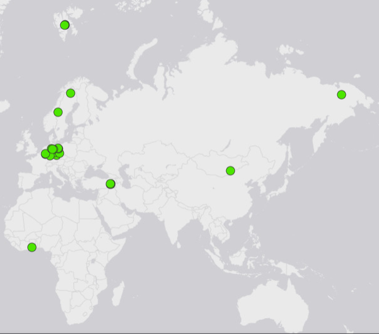
Locations of the drill cores in the BGR core repositories
At its four sites in Berlin-Spandau, Celle, Grubenhagen and Hanover (two storage facilities), BGR stores over 162,000 linear meters of drill cores. The Grubenhagen site and a core storage facility in Hanover are used jointly with the State Authority for Mining, Energy and Geology of Lower Saxony (LBEG). The stored drill cores originate from research drilling (e.g. research projects: BGR, BMBF, GESEP and ICDP), transfers from the oil industry, repository research and planning (e.g. Mont Terri, Asse, Gorleben, Morsleben and Konrad) as well as underground energy storage and geothermal energy projects. The locations of the boreholes are distributed worldwide and visualized on a map. Further information on other BGR online services is linked.
Simple
- Alternate title
-
Bohrkerndaten
- Date (Publication)
- 2022-11-07
- Date (Revision)
- 2026-02-13
- Citation identifier
- 1ba7fcb6-2579-4ec5-c538-455190689be6
- Status
- Completed
-
GEMET - INSPIRE themes, version 1.0
-
-
Geologie
-
Geology
-
- Theme
-
-
Bohrkerne
-
Berlin Spandau
-
Nationales Bohrkernlager
-
ICDP
-
Forschungsbohrungen
-
GESEP
-
BMBF
-
core
-
National Core Repository
-
research drillings
-
Asse
-
Endlagerung
-
final disposal
-
Endlagererkundung
-
repository exploration
-
Mont Terri
-
Konrad
-
Morsleben
-
Gorleben
-
Geothermie
-
geothermal Energie
-
Kavernen
-
caverns
-
Kernhalle Hannover
-
core repository hanover
-
Kernmagazin Grubenhagen
-
core repository Grubenhagen
-
- Access constraints
- Other restrictions
- Other constraints
- Es gelten keine Zugriffsbeschränkungen
- Use constraints
- Other restrictions
- Other constraints
-
Allgemeine Geschäftsbedingungen, siehe https://www.bgr.bund.de/AGB - General terms and conditions, see https://www.bgr.bund.de/AGB_en . Die bereitgestellten Informationen sind bei Weiterverwendung wie folgt zu zitieren: Datenquelle: Bohrkerndatendienst, (c) BGR, 2022
- Spatial representation type
- Vector
- Language
- Deutsch
- Character set
- UTF8
- Topic category
-
- Geoscientific information
))
- Unique resource identifier
- EPSG:4326
- Distribution format
-
-
WMS
(
OGC:WMS 1.3.0
)
-
WMS
(
OGC:WMS 1.3.0
)
- OnLine resource
- Karte im BGR-Geoviewer
- OnLine resource
- BGR-Webseite
- OnLine resource
- Kernlagerdatenbank
- Hierarchy level
- Dataset
Conformance result
- Date (Publication)
- 2010-12-08
- Explanation
-
siehe dazu die angegebene Durchführungsbestimmung
- Statement
-
Die Bohrdaten stammen aus den Datenbanken des Nationalen Bohrkernlagers Deutschland (OpenDIS – Open Drilling Information System) und dem Bohrkern- und Proben-Informationssystem (BohrIS).
- File identifier
- 7d65d95a-909f-42a8-8689-81e0a26eea11 XML
- Metadata language
- Deutsch
- Character set
- UTF8
- Hierarchy level
- Dataset
- Hierarchy level name
-
Geologie
- Date stamp
- 2026-02-13
- Metadata standard name
-
INSPIRE Metadata Implementing Rules: Technical Guidelines based on EN ISO 19115 and EN ISO 19119
- Metadata standard version
-
n/a
Overviews
Spatial extent
Provided by
