 My GeoNetwork catalogue
Reservoir-modelling and parametrization of a potential reservoir structure (Pilot area B) in the German North Sea
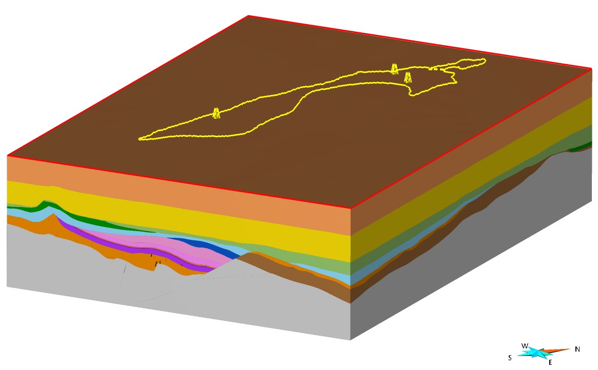
As part of the CDRmare joint project GEOSTOR ( https://geostor.cdrmare.de/ ), the BGR created detailed static geological 3D models for two potential CO2 storage structures in the Middle Buntsandstein in the Exclusive Economic Zone (EEZ) of the German North Sea and supplemented them with petrophysical parameters (e.g. porosities, permeabilities). The 3D geological model (Pilot area B; ~560 km2) is located in the north-western part of the German North Sea sector, the so-called “Entenschnabel”, an approximately 150 kilometer long and 30 kilometer wide area between the offshore sectors of the Netherlands, Denmark and Great Britain (pilot region B). The model in the Ducks Beak is based on several high-resolution 3D seismic data and geophysical/geological information from four exploration wells. It includes 20 generalized faults and the following 16 horizon surfaces: 1) Sea Floor, 2) Mid Miocene Unconformity, 3) Base Tertiary, 4) Base Upper Cretaceous, 5) Base Lower Cretaceous, 6) Base Upper Jurassic, 7) Base Lower Jurassic, 8) Base Muschelkalk, 9) Base Röt, 10) Base Solling Formation, 11) Base Detfurth Formation, 12) Base Volpriehausen Wechselfolge, 13) Base Volpriehausen Formation, 14) Base Triassic, 15) Base Zechstein, 16) Top Basement. The reservoir formed by sandstones of the Middle Buntsandstein is located within the Mads Graben, which is bounded to the west by the extensive Mads Fault (normal fault). Marine mudstones of the Upper Jurassic and Lower Cretaceous serve as the main seal formations. Petrophysical analyses of all considered well data were conducted and reservoir properties (including porosity and permeability) were calculated to determine the static reservoir capacity for these potential CO2 storage structures. The model parameterized and can be used for further dynamic simulations of storage capacity, geo-risk, and infrastructure analyses, in order to develop a comprehensive feasibility study for potential CO2 storage within the project framework. The 3D models were created by the BGR between 2021 and 2024. SKUA-GOCAD was used as the modeling software. We would like to thank AspenTech for providing licenses for their SSE software package as part of the Academic Program ( https://www.aspentech.com/en/academic-program ).
Simple
- Alternate title
-
RM_P-B
- Date (Publication)
- 2024-07-10
- Citation identifier
- d1c7879f-e31a-44cf-0db0-db6c9f64c80f
- Status
- Completed
-
GEMET - INSPIRE themes, version 1.0
-
-
Geologie
-
Geology
-
- Theme
-
-
geological model
-
static model
-
opendata
-
Pilotgebiet B
-
- Place
-
-
North Sea
-
Ducks Beak
-
- Access constraints
- Other restrictions
- Other constraints
- Es gelten keine Zugriffsbeschränkungen
- Use constraints
- Other restrictions
- Other constraints
-
{ "id": "dl-by-de/2.0", "name": "Datenlizenz Deutschland Namensnennung 2.0", "url": " https://www.govdata.de/dl-de/by-2-0 ", "quelle": "BGR, RM_P-B, 2024" }
- Spatial representation type
- Vector
- Language
- English
- Character set
- UTF8
- Topic category
-
- Geoscientific information
))
- Unique resource identifier
- EPSG:23031
- Distribution format
-
-
online
(
n/a
)
-
GOCAD
(
n/a
)
-
online
(
n/a
)
- OnLine resource
- Modell im 3D-Viewer
- OnLine resource
- BGR-Projektseite
- OnLine resource
- Modell im Format GOCAD
- OnLine resource
- Geostor-Webseite
- OnLine resource
- Geostor-Datenkatalog
- Hierarchy level
- Dataset
Conformance result
- Date (Publication)
- 2010-12-08
- Explanation
-
siehe dazu die angegebene Durchführungsbestimmung
- Statement
-
Based on seismic data - available via GeolDG. Basierend auf seismischen Daten - verfügbar über GeolDG.
- File identifier
- 8469e527-1e0b-4cfa-a5d4-2f1c79ca0be1 XML
- Metadata language
- English
- Character set
- UTF8
- Hierarchy level
- Dataset
- Hierarchy level name
-
Geologie
- Date stamp
- 2026-01-13
- Metadata standard name
-
INSPIRE Metadata Implementing Rules: Technical Guidelines based on EN ISO 19115 and EN ISO 19119
- Metadata standard version
-
n/a
Overviews
Spatial extent
Provided by
