 My GeoNetwork catalogue
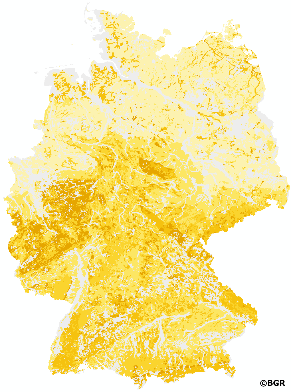
Background values for Lead (Pb) in German soils 1:1,000,000
New, nationwide background values for 16 heavy metals and trace elements were published by the LABO in 2017. They are based on profile descriptions and measurements of aqua regia extracts, which were combined and homogenized by the BGR. Measurements with high quantification limits were excluded from further evaluation according to certain criteria in order to avoid their influence on the derivation of background values. To prevent the background values from being disproportionately influenced by regions with high sample densities, spatial thinning was partially performed. The values of several horizons of a site were combined to one value by depth-weighted averages. For evaluation, the available measured values were assigned to different groups of soil parent materials. In addition, a distinction was made whether the samples were taken in the topsoil, in the subsoil or in the underground. In the case of topsoil, the different land use (arable land, grassland, forest) was also taken into account for the evaluation. Unconsolidated rocks were evaluated separately for northern and southern Germany due to their different composition. By dividing the data into sub-collectives, reliable case numbers were not achieved in all cases. Consequently, only background values with case numbers ?20 are presented. The exact derivation procedure can be found in the report of the LABO-Bund/Länder-Arbeitsgemeinschaft Bodenschutz (2017): 'Hintergrundwerte für anorganische und organische Stoffe in Böden', 4th revised and supplemented edition.
Simple
- Alternate title
-
HGW1000_Pb
- Date (Creation)
- 2018-06-01
- Date (Publication)
- 2022-01-03
- Date (Revision)
- 2022-03-22
- Edition
-
Version 2.0
- Citation identifier
- c9a7ad70-8f38-11e8-8d4f-8851fb422c62
- Status
- Completed
-
GEMET - INSPIRE themes, version 1.0
-
-
Soil
-
Boden
-
-
SGD-Liste
-
-
Belastung
-
Entstehungsart
-
Schadstoff
-
Gesteinszusammensetzung
-
Bodeneigenschaften
-
-
Freies Schlagwort
-
-
Deutschland
-
Hintergrundwerte
-
Anorganische Spurenstoffe
-
Boden
-
Schwermetall
-
Blei
-
Pb
-
- Place
-
-
Bundesrepublik Deutschland
-
- Access constraints
- Other restrictions
- Other constraints
- Es gelten keine Zugriffsbeschränkungen
- Use constraints
- Other restrictions
- Other constraints
-
Allgemeine Geschäftsbedingungen, siehe https://www.bgr.bund.de/AGB - General terms and conditions, see https://www.bgr.bund.de/AGB_en . Die bereitgestellten Informationen sind bei Weiterverwendung wie folgt zu zitieren: Datenquelle: HGW1000_Pb V2.0, (c) BGR, Hannover, 2017
- Distance
- 1000 m
- Denominator
- 1000000
- Language
- Deutsch
- Character set
- UTF8
- Topic category
-
- Geoscientific information
))
- Geographic identifier
- Regionalschlüssel / 000000000000
- Unique resource identifier
- EPSG:3035
- Distribution format
-
-
Shapefile
(
n/a
)
-
PDF
(
n/a
)
-
Shapefile
(
n/a
)
- Transfer size
- 15
- OnLine resource
-
HGW1000_Pb (Shapefile)
HGW1000_Pb im Format ESRI Shape
- Transfer size
- 62
- OnLine resource
-
HGW1000_Pb (PDF)
HGW1000_Pb im Format PDF Dateien (Auflösung 600 dpi)
- OnLine resource
- Bericht der LABO-Bund/Länder-Arbeitsgemeinschaft Bodenschutz
- OnLine resource
- Karte im BGR-Geoviewer
- Hierarchy level
- Dataset
Conformance result
- Date (Publication)
- 2010-12-08
- Explanation
-
siehe dazu die angegebene Durchführungsbestimmung
- Statement
-
- LABO (2017): Hintergrundwerte für anorganische und organische Stoffe in Böden. 4. überarbeitete und ergänzte Auflage. Bund/Länder-Arbeitsgemeinschaft Bodenschutz (LABO), Kiel. - W. Duijnisveld, L. Konen, F. Krone, F. Stange (2017): Bundesweite Hintergrundwerte für anorganische Stoffe in Böden. Bundesanstalt für Geowissenschaften und Rohstoffe, Hannover, im Auftrag des Umweltbundesamtes, Dessau-Roßlau. - Länderübergreifende Datensätze der Bundesanstalt für Geowissenschaften und Rohstoffe, des Umweltbundesamtes und der Bodenzustandserhebung im Wald (BZE II) - Daten der Geologischen Landesämter/Dienste und/oder Landesumweltämter in Baden-Württemberg, Bayern, Brandenburg, Hessen, Mecklenburg-Vorpommern, Niedersachsen, Nordrhein-Westfalen, Rheinland-Pfalz, Saarland, Sachsen, Sachsen-Anhalt, Schleswig-Holstein und Thüringen. - Nutzungsdifferenzierte Bodenübersichtskarte von Deutschland 1 : 1 000 000, Version 2.31 (FISBo BGR).
- File identifier
- 85c880ef-e377-410b-96b5-574b9b7967a8 XML
- Metadata language
- Deutsch
- Character set
- UTF8
- Parent identifier
-
Heavy metal and trace element background values in German soils 1:1,000,000
1cbb6b20-7f3d-4560-8f4a-87de08e0ffc9
- Hierarchy level
- Dataset
- Hierarchy level name
-
Boden
- Date stamp
- 2025-08-14
- Metadata standard name
-
INSPIRE Metadata Implementing Rules: Technical Guidelines based on EN ISO 19115 and EN ISO 19119
- Metadata standard version
-
n/a
Overviews
Spatial extent
Provided by
