 My GeoNetwork catalogue
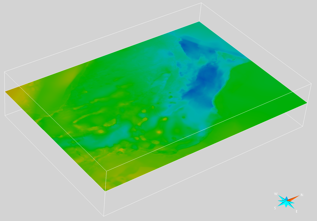
Harmonized, cross-border seismic velocity model for the Dutch, German and Danish North Sea area (Project 3DGEO-EU)
Within the GeoEra research project "3D Geomodeling for Europe” (3DGEO-EU, 2018-2021), a harmonized cross-border seismic velocity model for time-depth conversion was developed, covering main parts of the Danish, German, and northern Dutch North Sea. The model was created through collaboration between the Netherlands Organization for Applied Scientific Research (TNO, NL), the Geological Survey of Denmark and Greenland (GEUS, DK) and the Federal Institute for Geosciences and Natural Resources (BGR, GER). The transnational velocity model combines a V0-K layer-cake velocity model for Cenozoic and Mesozoic units with a Vint-DeltaT velocity model used for the Zechstein interval. In total, seven main stratigraphic layers were selected by the project partners to build the velocity model. As input data, velocity information gathered from 724 wells was used. For the Entenschnabel region covering the northwestern part of the German North Sea sector and adjacent areas in Denmark and the Netherlands, the original layer-cake velocity model compiled in Petrel (Doornenbal et al., 2021) was converted into two seismic velocity volumes with average velocities using Paradigm SeisEarth (Thöle et al., 2021). One volume was computed with salt structures modeled as vertical shapes, consistent with the original Petrel model, while the other was modeled without salt structures down to the base of the Triassic to correct for velocity pull-down effects beneath salt dome overhangs. For details on the creation of the transnational velocity model and the seismic velocity volumes, the reader is referred to Doornenbal et al. (2021), Thöle et al. (2021) and Bense et al. (2022). Doornenbal, H., den Dulk, M., Thöle, H., Jähne-Klingberg, F., Britze, P. & Jakobsen, F. (2021): Deliverable 3.7 – A harmonized cross-border velocity model. GEOERA 3DGEO-EU; 3D Geomodeling for Europe; project number GeoE.171.005, Report. Thöle, H., Jähne-Klingberg, F., Doornenbal, H., den Dulk, M., Britze, P. & Jakobsen F. (2021): Deliverable 3.8 – Harmonized depth models and structural framework of the NL-GER-DK North Sea. GEOERA 3DGEO-EU; 3D Geomodeling for Europe; project number GeoE.171.005, Report. Bense, F., Deutschmann, A., Dzieran, L., Hese, F., Höding, T., Jahnke, C., Lademann, K., Liebsch-Dörschner, T., Müller, C.O., Obst, K., Offermann, P., Schilling, M., Wächter, J. (2022): Potenziale des unterirdischen Speicher- und Wirtschaftsraumes im Norddeutschen Becken (TUNB) - Phase 2: Parametrisierung. Abschlussbericht. Bundesanstalt für Geowissenschaften und Rohstoffe (BGR), p. 193.
Simple
- Alternate title
-
Vmod_3DGEO-EU_NL_GER_DK_North_Sea
- Date (Publication)
- 2025-04-28
- Edition
-
Version 1.0
- Citation identifier
- https://registry.gdi-de.org/id/de.bund.bgr.csw/4c9df2ec-6ba4-d19b-9494-8c71c1894306
- Status
- Completed
-
GEMET - INSPIRE themes, version 1.0
-
-
Geologie
-
Geology
-
-
GEMET - Concepts, version 4.1.4
-
-
Modell
-
- Theme
-
-
3DGEO-EU
-
velocity model
-
seismic velocity volume
-
opendata
-
Geschwindigkeitsmodell
-
- Place
-
-
North Sea
-
- Access constraints
- Other restrictions
- Other constraints
- Es gelten keine Zugriffsbeschränkungen
- Use constraints
- Other restrictions
- Other constraints
-
Dieser Datensatz kann gemäß der "Datenlizenz Deutschland Namensnennung 2.0" ( https://www.govdata.de/dl-de/by-2-0 ) unter Angabe des Quellenvermerks "BGR, GEUS, TNO (2021): Harmonized, cross-border seismic velocity model for the Dutch, German and Danish North Sea area (Project 3DGEO-EU). https://gst.bgr.de , Abgerufen am xx.xx.xxxxx" genutzt werden.
- Other constraints
-
{ "id": "dl-by-de/2.0", "name": "Datenlizenz Deutschland Namensnennung 2.0", "url": " https://www.govdata.de/dl-de/by-2-0 ", "quelle": "BGR, GEUS, TNO (2021): Harmonized, cross-border seismic velocity model for the Dutch, German and Danish North Sea area (Project 3DGEO-EU). https://gst.bgr.de , Abgerufen am xx.xx.xxxxx" }
- Language
- English
- Character set
- UTF8
- Topic category
-
- Geoscientific information
))
- Unique resource identifier
- EPSG:23031
- Distribution format
-
-
online
(
n/a
)
-
SEG-Y
(
n/a
)
-
online
(
n/a
)
- OnLine resource
- Modell im BGR-3D-Viewer
- OnLine resource
- Projektseite
- OnLine resource
- Fachbericht "3DGEO-EU: Deliverable 3.7"
- OnLine resource
- Fachbericht "3DGEO-EU: Deliverable 3.8"
- OnLine resource
-
Modell - Download
Modell - Download
- Hierarchy level
- Dataset
Conformance result
- Date (Publication)
- 2010-12-08
- Explanation
-
siehe dazu die angegebene Durchführungsbestimmung
- Statement
-
The velocity model was developed within the GeoEra research project "3D Geomodeling for Europe” (3DGEO-EU, 2018-2021) by the Netherlands Organization for Applied Scientific Research (TNO, NL), the Geological Survey of Denmark and Greenland (GEUS, DK), and the Federal Institute for Geosciences and Natural Resources (BGR, GER). As input data, velocity information gathered from 724 wells was used. ( https://geoera.eu/projects/3dgeo-eu/ )
- File identifier
- 872cf5ca-4b84-4411-acf0-c8a0adcb5c79 XML
- Metadata language
- English
- Character set
- UTF8
- Hierarchy level
- Dataset
- Hierarchy level name
-
Geologie
- Date stamp
- 2025-06-05
- Metadata standard name
-
INSPIRE Metadata Implementing Rules: Technical Guidelines based on EN ISO 19115 and EN ISO 19119
- Metadata standard version
-
n/a
Overviews
Spatial extent
Provided by
