 My GeoNetwork catalogue
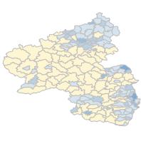
Flächennutzung 2022 - Wohnbau, Anteil an der Bodenfläche in % (Verbandsgemeindeebene)
Thematische Karten zur Flächennutzung in Rheinland-Pfalz nach ausgesuchten Flächenarten. Anteil der Siedlungs- und Verkehrsfläche, der Waldfläche sowie der Landwirtschaftsfläche in %. Bevölkerungsdichte in Einwohner je qKm. Stand 31.12.2022:Fläche für Siedlung, Anteil an der Bodenfläche in % , Verbandsgemeindeebene
Simple
Identification info
- Date (Revision)
- 2024-06-30
-
mapbender.2.registryId
-
-
2f23ed6e-0186-4c2b-8380-748389036509
-
- Keywords
-
-
Flächennutzung
-
Kreisdaten
-
Siedlungsfläche
-
infoMapAccessService
-
- Access constraints
- Other restrictions
- Other constraints
- Es gelten keine Zugriffsbeschränkungen
- Use constraints
- Other restrictions
- Other constraints
-
Lizenz: cc-by-3.0 - Creative Commons: Namensnennung 3.0 Deutschland - http://creativecommons.org/licenses/by/3.0/de/ - Quellenvermerk: Source note required by license, but not given!
- Other constraints
-
{"id":"cc-by-3.0","name":"Creative Commons: Namensnennung 3.0 Deutschland","url":"http:\/\/creativecommons.org\/licenses\/by\/3.0\/de\/","quelle":"Source note required by license, but not given!"}
- Service Type
- view
- Service Version
-
OGC:WMS 1.1.1
))
- Coupling Type
- Loose
Contains Operations
- Operation Name
-
GetCapabilities
- Distributed Computing Platforms
- Web services
- Distribution format
-
- OnLine resource
-
GEB1L4VG
(
OGC:WMS-1.1.1-http-get-map
)
Fläche für Siedlung, Anteil an der Bodenfläche in % , Verbandsgemeindeebene
- Hierarchy level
- Service
- Other
-
Dienst
Conformance result
- Date (Publication)
- 2010-12-08
- Explanation
-
No explanation available
- Pass
- Yes
Conformance result
- Date (Publication)
- 2009-10-20
- Explanation
-
No explanation available
- Pass
- Yes
Conformance result
- Date (Publication)
- 2014-12-11
- Explanation
-
No explanation available
- Pass
- Yes
Conformance result
- Date (Publication)
- 2008-12-04
- Explanation
-
No explanation available
- Pass
- Yes
Conformance result
- Date (Publication)
- 2014-12-11
- Explanation
-
No explanation available
- Pass
- Yes
Conformance result
- Date (Publication)
- 2013-12-10
- Explanation
-
No explanation available
- Pass
- Yes
Conformance result
- Date (Publication)
- 2011-02-05
- Explanation
-
No explanation available
- Pass
- Yes
Conformance result
- Date (Publication)
- 2010-12-08
- Explanation
-
No explanation available
- Pass
- Yes
- File identifier
- 8b7018f2-f42c-5cfa-d0fc-bf03554b3da5 XML
- Metadata language
- Deutsch
- Character set
- UTF8
- Hierarchy level
- Service
- Hierarchy level name
-
Darstellungsdienst
- Date stamp
- 2026-04-26
- Metadata standard name
-
ISO19119
- Metadata standard version
-
2005/PDAM 1
Overviews
Spatial extent
Provided by
