 My GeoNetwork catalogue
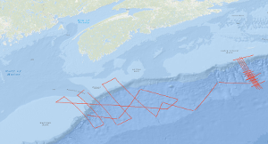
Processed seismic data of Cruise BGR79/2 1979
In the frame of the Continental Margin Study Program of the Federal Institute for Geosciences and Natural Resources (BGR, Hannover) marine geophysical measurements (48-channel reflection seismic, sono-buoy refraction, gravity and magnetic) were conducted over the Atlantic continental margin of Canada from 23th July to 7th August 1979 with S.V. EXPLORA (BGR79 leg 2). The survey on the Canadian continental margin was planned in cooperation between the Federal Institute for Geosciences and Natural Resources (BGR) and the Atlantic Geoscience Centre of the Geological Survey of Canada (Bedford Institute of Oceanography, Dartmonth, N.S.) on the base of existing Canadian multichannel seismic lines. A main target of the cruise was to acquire data which allow a comparison of the deep sedimentary basins offshore Nova Scotia with the already known basins offshore Morocco. The eastern part of the survey imaged complex structural deformation due to salt diapirs. The western seismic lines allowed to investigate the structural relationship between the Scotian Basin and the Georges Bank.
Simple
- Alternate title
-
BGR79/2 1979
- Date (Creation)
- 1979-08-07
- Citation identifier
- dd0fa6a4-782b-ac21-8ec7-10366dedea05
- Status
- Completed
-
GEMET - INSPIRE themes, version 1.0
-
-
Geologie
-
geology
-
-
GEMET - Concepts, version 2.4
-
-
geophysics
-
Geophysik
-
raw material
-
Rohstoff
-
- Theme
-
-
Marine geology
-
Meeresgeologie
-
Seismics
-
Seismik
-
Two-dimensional seismic reflection
-
zweidimensionale Reflektionsseismik
-
- Place
-
-
Northwest Atlantic Ocean
-
Nordwest-Atlantik
-
Nova Scotia
-
Neuschottland
-
Scotian Basin
-
- Access constraints
- Other restrictions
- Other constraints
- Es gelten keine Zugriffsbeschränkungen
- Use constraints
- Other restrictions
- Other constraints
-
Allgemeine Geschäftsbedingungen, siehe http://www.bgr.bund.de/AGB - General terms and conditions, see http://www.bgr.bund.de/AGB_en . Die bereitgestellten Informationen sind bei Weiterverwendung wie folgt zu zitieren: Datenquelle: BGR79/2 1979, (c) BGR, Hannover, 2018
- Spatial representation type
- Vector
- Language
- English
- Character set
- UTF8
- Topic category
-
- Geoscientific information
))
- Unique resource identifier
- EPSG:4326
- Distribution format
-
-
Shapefile
(
n/a
)
-
Shapefile
(
n/a
)
- Transfer size
- 1
- OnLine resource
-
BGR79/2 1979 (Shapefile)
BGR79/2 1979 im Format ESRI Shape
- OnLine resource
- Profile BGR79-101
- OnLine resource
- Profile BGR79-102
- OnLine resource
- Profile BGR79-103
- OnLine resource
- Profile BGR79-104
- OnLine resource
- Profile BGR79-107
- OnLine resource
- Profile BGR79-109
- OnLine resource
- Profile BGR79-111
- OnLine resource
- Profile BGR79-112
- OnLine resource
- Profile BGR79-113
- OnLine resource
- Profile BGR79-114
- OnLine resource
- Profile BGR79-115
- OnLine resource
- Profile BGR79-118
- OnLine resource
- Profile BGR79-119
- OnLine resource
- Profile BGR79-120
- OnLine resource
- Profile BGR79-121
- OnLine resource
- Profile BGR79-124
- OnLine resource
- Profile BGR79-125
- OnLine resource
- Profile BGR79-126
- OnLine resource
- Profile BGR79-127
- OnLine resource
- Profile BGR79-128
- OnLine resource
- Profile BGR79-129
- OnLine resource
- Profile BGR79-130
- OnLine resource
- Profile BGR79-131
- OnLine resource
- Profile BGR79-132
- OnLine resource
- Profile BGR79-133
- OnLine resource
- Profile BGR79-134
- OnLine resource
- Profile BGR79-135
- OnLine resource
- Profile BGR79-136
- OnLine resource
- Karte im BGR-Geoviewer
- Hierarchy level
- Dataset
Conformance result
- Date (Publication)
- 2010-12-08
- Explanation
-
siehe dazu die angegebene Durchführungsbestimmung
- Statement
-
During the period from the 23th July 1979 to the 7th August 1979 BGR acquired seismic lines in the Northwest Atlantic Ocean off the off the continental margin of Canada during the leg BGR79/2. The lines BGR79-105, BGR79-106, BGR79-108, BGR79-110, BGR79-116, BGR79-117, BGR79-122 and BGR79-123 are raw data. The lines BGR79-101, BGR79-102, BGR79-103, BGR79-104, BGR79-107, BGR79-109, BGR79-111, BGR79-112, BGR79-113, BGR79-114, BGR79-115, BGR79-118, BGR79-119, BGR79-120, BGR79-121, BGR79-124, BGR79-125, BGR79-126, BGR79-127, BGR79-128, BGR79-129, BGR79-130, BGR79-131, BGR79-132, BGR79-133, BGR79-134, BGR79-135 and BGR79-136 consist of stacked data.
- File identifier
- 948de0cb-d60a-4bb0-9f45-f4990becceb1 XML
- Metadata language
- English
- Character set
- UTF8
- Parent identifier
-
Marine Seismic Survey Profiles (MSSP)
06a73c56-06a2-40d8-b806-466222b0760d
- Hierarchy level
- Dataset
- Hierarchy level name
-
Geophysik
- Date stamp
- 2023-11-14
- Metadata standard name
-
INSPIRE Metadata Implementing Rules: Technical Guidelines based on EN ISO 19115 and EN ISO 19119
- Metadata standard version
-
n/a
Overviews
Spatial extent
Provided by
