 My GeoNetwork catalogue
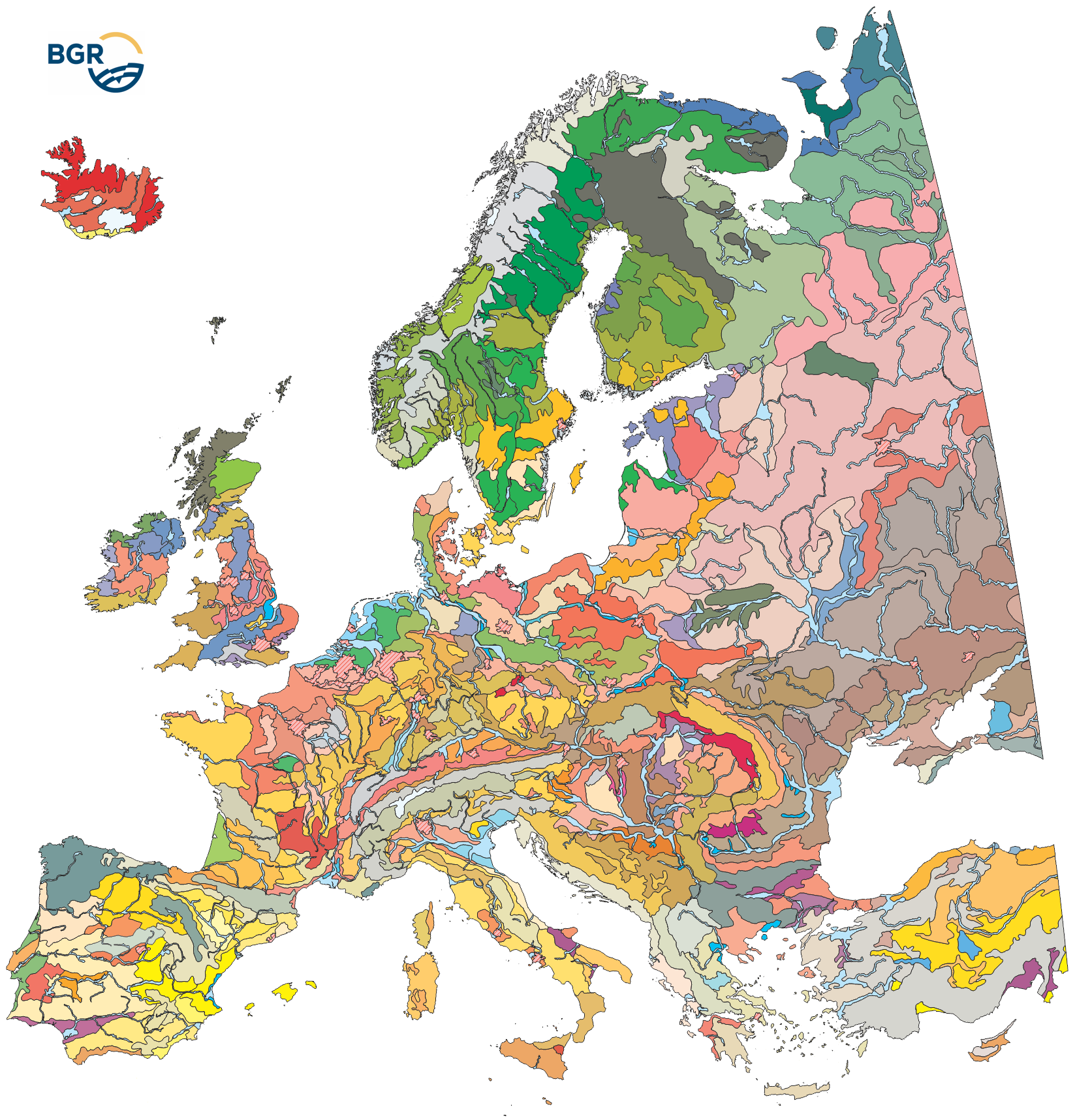
Soil Regions of the European Union and Adjacent Countries 1:5,000,000
The map of the "Soil Regions of the European Union and Adjacent Countries 1 : 5 000 000 (Version 2.0)" is published by the Federal Institute of Geosciences and Natural Resources (BGR), in partnership with the Joint Research Center (JRC, Ispra). The soil regions map is intended to support the current national mapping activities towards a European 1:250,000 datbase by stratifying similar regional soil associations into a hierarchical concept. Only by stratification, the complexity of soils can be systematically structured so that the complex 1:250.000 legend can be handled in cross-national and contintental-level applications. Soil regions are natural, cross-regional soil geographical units which perform the highest spatial and content-based aggregation of European soils. They represent the frame conditions for soil development at the landscape level. The soil regions are presented at scale 1:5,000,000. Thus, its borders are highly generalized. Because of its low resolution, the map units absorb atypical soils and associations of soils, which are only described in higher resolution soil maps. The delineation of the soil regions is expected to be refined (and probably improved by its content) during the actual 1:250,000 mapping process. Thus, updating can be expected in the future. Currently, the soil regions map is the only graphical soil representation in Europe which has been developed using fully comparable and harmonized basic data at the continental level (climate, hydrography, relief, geology, vegetation): the interpretation of this input data, and the utilization of expert knowledge (including the interpretation of regional soil maps) has been done using one common methodology, developed and applied consistently throughout the whole mapping area by an experienced international soil mapper (Dr. Reinhard Hartwich, former member of BGR, and co-author of the 1998 Manual of Procedures). The methodology is extensively described in the Explanatory Notes (German), and in the revised Manual of Procedures which is expected to be completed soon.
Simple
- Alternate title
-
EUSR5000
- Date (Publication)
- 2005-08-09
- Edition
-
Version 2.0
- Citation identifier
- 78F40629-3272-40F6-B0AA-C0A353F7A391
- Citation identifier
- https://doi.org/10.25928/EUSR5000_2.0
- Status
- Completed
-
GEMET - INSPIRE themes, version 1.0
-
-
Soil
-
- Theme
-
-
Boden
-
Bodeneigenschaften
-
Bodenlandschaften
-
Bodenregionen
-
Bodenverbreitung
-
Climate areas
-
Entstehungsart
-
landscape stratification
-
Soil landscapes
-
Soil parent material associations
-
soil regions
-
Soil scapes
-
EGDI
-
- Place
-
-
Europa
-
Europe
-
- Access constraints
- Other restrictions
- Other constraints
- Es gelten keine Zugriffsbeschränkungen
- Use constraints
- Other restrictions
- Other constraints
-
General Standard Terms and Conditions (GSTC) of the Federal Institute for Geosciences and Natural Resources (BGR). The LBEG or the BGR is the owner of the rights of exploitation for software, digital data, and other products protected by copyright, as well as know-how. The contractual partner receives a simple right of use for the types of use defined in the following. The right to duplicate and present is also transferred. The rights which are not transferred include in particular the right to make accessible to the public, unless the contractual partner makes the aforementioned accessible to the public within the framework of an administrative procedure when acting as a participating authority in said administrative procedure. For the purpose of reuse the provided information has to be quoted as follows: BGR [Bundesanstalt für Geowissenschaften und Rohstoffe] (2005). Soil Regions Map of the European Union and Adjacent Countries 1:5,000,000 (Version 2.0). Special Publication, Ispra. EU catalogue number S.P.I.05.134.
- Spatial representation type
- Vector
- Denominator
- 5000000
- Language
- English
- Character set
- UTF8
- Topic category
-
- Geoscientific information
))
- Unique resource identifier
- EPSG:3035
- Distribution format
-
-
PDF
(
n/a
)
-
Shapefile
(
n/a
)
-
JPEG
(
n/a
)
-
MS Access
(
n/a
)
-
PNG
(
n/a
)
-
TIFF
(
n/a
)
-
GeoPackage
(
n/a
)
-
SQLite
(
n/a
)
-
PDF
(
n/a
)
- Transfer size
- 108
- OnLine resource
-
EUSR5000 (PDF)
EUSR5000 im Format Adobe Acrobat Datei (Auflösung 600 dpi)
- Transfer size
- 42
- OnLine resource
-
EUSR5000 (PDF/Notes)
EUSR5000 im Format Erläuterungsband inkl. Beispielkarten (pdf)
- OnLine resource
-
EUSR5000 (Shapefile)
EUSR5000 im Format ESRI Shape
- Transfer size
- 33
- OnLine resource
-
EUSR5000 (JPEG)
EUSR5000 im Format JPEG (Auflösung 150 dpi)
- Transfer size
- 100
- OnLine resource
-
EUSR5000 (MS Access)
EUSR5000 im Format Microsoft Access Datenbank (Office XP/2003, 2007)
- Transfer size
- 16
- OnLine resource
-
EUSR5000 (PNG)
EUSR5000 im Format PNG (Auflösung 150 dpi)
- Transfer size
- 94
- OnLine resource
-
EUSR5000 (TIFF)
EUSR5000 im Format TIFF (Auflösung 300 dpi)
- OnLine resource
- EUSR5000-Internetseite - EUSR5000-Website
- OnLine resource
- Karte im BGR-Geoviewer
- OnLine resource
-
EUSR5000 (GeoPackage)
EUSR5000 im Format GeoPackage
- OnLine resource
-
EUSR5000 (SQLite)
EUSR5000 im Format SQLite
- Hierarchy level
- Dataset
- Statement
-
Die Datenquellen sind in Hartwich et al. (2005) gelistet und erläutert: - Europaweite thematische Karten und Datensätze - Nationale/regionale Bodenkarten und Expertenwissen von Mitgliedern des European Soil Bureau Network (ESBN) - The data sources are listed, explained and cited in Hartwich et al. (2005): - Europe-wide thematic maps and data sets - national/regional soil maps and expert knowledge from members of the European Soil Bureau Network (ESBN)
- File identifier
- AE71FFEE-1AE9-4624-AE3F-F49513FE9DCB XML
- Metadata language
- English
- Character set
- UTF8
- Hierarchy level
- Dataset
- Hierarchy level name
-
Boden
- Date stamp
- 2025-09-05
- Metadata standard name
-
INSPIRE Metadata Implementing Rules: Technical Guidelines based on EN ISO 19115 and EN ISO 19119
- Metadata standard version
-
n/a
Overviews
Spatial extent
Provided by
