 My GeoNetwork catalogue
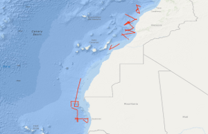
Processed seismic data of Cruise VA79 1979
In the period from September 25th to October 19th 1979 5,260 km of magnetic, gravity and bathymetric lines and 3,567 km of reflection seismic lines were recovered on the first leg of the VALDIVIA Westafrica-cruise 1979 with the research objective to study similarities and differences in the geological development of physiographically different Northwest African continental margin segments. Test measurements have been carried out during this cruise with an “implosive" seismic sound source. The software for acquisition, calculation and presentation of gravity, magnetic and bathymetric data has been developed so that onboard presentation of free-air anomalies, Bouguer anomalies, anomalies of the earth's magnetic field and of the bathymetry could be achieved. Differences within the regional geological development of the Northwest African continental margin has been confirmed. Parts of the Moroccan continental margin are modified by a Cretaceous epirogenic uplift associated with block—faulting and halokinesis. Tertiary folding of the Western High Atlas extends into the shelf of the Tafelney Plateau segment.
Simple
- Alternate title
-
VA79 1979
- Date (Creation)
- 1979-10-21
- Citation identifier
- 7a69b1a7-1ee2-b70a-e3d4-e7b37dacfe20
- Status
- Completed
-
GEMET - INSPIRE themes, version 1.0
-
-
Geologie
-
geology
-
-
GEMET - Concepts, version 2.4
-
-
geophysics
-
Geophysik
-
raw material
-
Rohstoff
-
- Theme
-
-
Marine geology
-
Meeresgeologie
-
Seismics
-
Seismik
-
Two-dimensional seismic reflection
-
zweidimensionale Reflektionsseismik
-
- Place
-
-
Central East Atlantic
-
Zentraler Ostatlantik
-
Marokko
-
Morocco
-
Mauretanien
-
Mauritania
-
- Access constraints
- Other restrictions
- Other constraints
- Es gelten keine Zugriffsbeschränkungen
- Use constraints
- Other restrictions
- Other constraints
-
Allgemeine Geschäftsbedingungen, siehe http://www.bgr.bund.de/AGB - General terms and conditions, see http://www.bgr.bund.de/AGB_en . Die bereitgestellten Informationen sind bei Weiterverwendung wie folgt zu zitieren: Datenquelle: VA79 1979, (c) BGR, Hannover, 1979
- Spatial representation type
- Vector
- Language
- English
- Character set
- UTF8
- Topic category
-
- Geoscientific information
))
- Unique resource identifier
- EPSG:4326
- Distribution format
-
-
Shapefile
(
n/a
)
-
Shapefile
(
n/a
)
- Transfer size
- 2
- OnLine resource
-
VA79 1979 (Shapefile)
VA79 1979 im Format ESRI Shape
- OnLine resource
- Profile VA79-02
- OnLine resource
- Profile VA79-03
- OnLine resource
- Profile VA79-04
- OnLine resource
- Profile VA79-05
- OnLine resource
- Profile VA79-07
- OnLine resource
- Profile VA79-15
- OnLine resource
- Profile VA79-17
- OnLine resource
- Profile VA79-26
- OnLine resource
- Profile VA79-27
- OnLine resource
- Profile VA79-35
- OnLine resource
- Karte im BGR-Geoviewer
- Hierarchy level
- Dataset
Conformance result
- Date (Publication)
- 2010-12-08
- Explanation
-
siehe dazu die angegebene Durchführungsbestimmung
- Statement
-
During the period from the 25th September to the 18th October 1979 BGR acquired seismic lines off West Africa. Lines VA79-01, VA79-08, VA79-09, VA79-10, VA79-11, VA79-12, VA79-13A, VA79-13B, VA79-14, VA79-16, VA79-16A, VA79-17A, VA79-21, VA79-22, VA79-24, VA79-25 and VA79-28 to VA79-34 are raw data. VA79-02, VA79-03, VA79-04, VA79-15, VA79-17, VA79-26, VA79-27 and VA79-35 are processed (stacked) data. Lines VA79-05 and VA79-07 are processed (migrated) data.
- File identifier
- a6ef1127-490b-4df7-ab6d-8301d0c3c66c XML
- Metadata language
- English
- Character set
- UTF8
- Parent identifier
-
Marine Seismic Survey Profiles (MSSP)
06a73c56-06a2-40d8-b806-466222b0760d
- Hierarchy level
- Dataset
- Hierarchy level name
-
Geophysik
- Date stamp
- 2023-11-16
- Metadata standard name
-
INSPIRE Metadata Implementing Rules: Technical Guidelines based on EN ISO 19115 and EN ISO 19119
- Metadata standard version
-
n/a
Overviews
Spatial extent
Provided by
