 My GeoNetwork catalogue
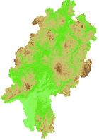
INSPIRE-WMS HE Höhenlage-Gitter-Coverage DOM1 - Elevation Grid Coverage (AdV-Farbschema)
Dieser Dienst stellt für das INSPIRE-Thema Höhe (Höhenlage-Gitter-Coverage) aus dem DOM1 umgesetzte Daten bereit.:Dieser Layer visualisiert die hessischen Höhenlagen abgeleitet aus dem DOM1 Datenmodell. Die Datengrundlage erfüllt die INSPIRE Datenspezifikation.
Simple
Identification info
- Alternate title
-
INSPIRE Höhe
- Date (Revision)
- 2026-02-25
-
mapbender.2.registryId
-
-
1c349fea-924b-488f-b6a2-e896f40ac897
-
- Keywords
-
-
Höhenlagengitter-Coverage
-
grid
-
coverage
-
DOM1
-
AdVMIS
-
infoMapAccessService
-
inspireidentifiziert
-
inspireidentifiziert
-
- Access constraints
- Other restrictions
- Other constraints
- INSPIRE: Keine Beschränkungen des öffentlichen Zugangs: Es existieren keine Beschränkungen des öffentlichen Zugangs zu Daten und Diensten
- Use constraints
- Other restrictions
- Other constraints
-
Der automatisierte Abruf und die Nutzung der Geobasisdaten und der zugeh_rigen Metadaten sind kostenfrei. (§ 24 Hessisches Vermessungs- und Geoinformationsgesetz - HVGG) - Lizenz: dl-zero-de/2.0 - Datenlizenz Deutschland – Zero – Version 2.0 - https://www.govdata.de/dl-de/zero-2-0
- Other constraints
-
{"id":"dl-zero-de/2.0","name":"Datenlizenz Deutschland \u2013 Zero \u2013 Version 2.0","url":" https://www.govdata.de/dl-de/zero-2-0"}
- Service Type
- view
- Service Version
-
OGC:WMS 1.1.1
))
- Coupling Type
- Tight
Contains Operations
- Operation Name
-
GetCapabilities
- Distributed Computing Platforms
- Web services
- Distribution format
-
- OnLine resource
-
EL.ElevationGridCoverage.AdV
(
OGC:WMS-1.1.1-http-get-map
)
Dieser Layer visualisiert die hessischen Höhenlagen abgeleitet aus dem DOM1 Datenmodell. Die Datengrundlage erfüllt die INSPIRE Datenspezifikation.
- Hierarchy level
- Service
- Other
-
Dienst
Conformance result
- Date (Publication)
- 2010-12-08
- Explanation
-
No explanation available
- Pass
- Yes
Conformance result
- Date (Publication)
- 2009-10-20
- Explanation
-
No explanation available
- Pass
- Yes
Conformance result
- Date (Publication)
- 2014-12-11
- Explanation
-
No explanation available
- Pass
- Yes
Conformance result
- Date (Publication)
- 2008-12-04
- Explanation
-
No explanation available
- Pass
- Yes
Conformance result
- Date (Publication)
- 2014-12-11
- Explanation
-
No explanation available
- Pass
- Yes
Conformance result
- Date (Publication)
- 2013-12-10
- Explanation
-
No explanation available
- Pass
- Yes
Conformance result
- Date (Publication)
- 2011-02-05
- Explanation
-
No explanation available
- Pass
- Yes
Conformance result
- Date (Publication)
- 2010-12-08
- Explanation
-
No explanation available
- Pass
- Yes
Overviews
Spatial extent
Provided by
