 My GeoNetwork catalogue
Processed seismic data of Cruise SO36 1985
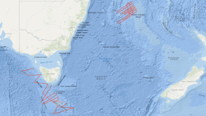
On the first leg of SONNE cruise SO-36 in the period from 11th February to 12th March 1985, geophysical investigations have been carried out on the Lord Howe Rise off eastern Australia by the Federal Institute for Geosciences and Natural Resources (BGR) in co-operation with the Bureau of Mineral Resources, Geology and Geophysics, Canberra. A total of 3,660 km of digital seismic reflection profiles, 6,740 km of gravity, magnetics, multibeam echosounder and sub-bottom profiler profiles, as well as 8 sonobuoy refraction profiles were recorded during this survey. A geomagnetic monitoring station of the BGR was operated during a part of the cruise on Lord Howe Island under the supervision of the BMR. These measurements provided a detailed picture of the structures of the survey area of the Lord Howe Rise. The samples proved that the Lord Howe Rise and the Dampier Ridge west of it consist of continental crust. Indications for structures rich in hydrocarbons were not observed. The 2nd and 3rd leg of SONNE cruise SO-36 were designed to investigate the structure, geological development and hydrocarbon potential of two frontier areas, the western and southwestern continental margin of Tasmania and the South Tasman Rise. On the 2nd leg (12.03.-12.04.1985) multichannel seismic reflection measurements were carried out in parallel with magnetic, gravimetric, sea-beam and 3.5 kHz subbottom profiler measurements on 19 lines with a total length of 3,820 km. In addition, 2,140 km were surveyed with magnetics, gravity meter, sea-beam and 3.5 kHz subbottom profiler in transit from and to Sydney, respectively. On the 3rd leg, which started in Sydney on 12th April 1985 and ended in Suva/Fiji one month later, 63 stations were sampled by dredging and coring with the aim (a) to provide lithology and biostratigraphic information about the seismic sequences mapped during leg 2, and (b) to obtain geochemical evidence of hydrocarbon generation from the character of gases absorbed onto the surficial sediment. Samples came from 33 stations off Western Tasmania, from 23 stations on the South Tasman Rise, and from 7 stations in the region of the Lord Howe Rise and the Dampier Ridge. In transit to the sampling sites, 11 single channel seismic lines with a total length of 470 km were surveyed, and in addition, 4,230 km were surveyed with magnetics, gravity meter, sea-beam, and subbottom profiler. Seven regional seismic unconformities were recognized and sampled, and the structural style of both areas was established. Thermogenic hydrocarbons in substantial concentration were found in the surface sediments at the western Tasmanian slope.
Simple
- Alternate title
-
SO36 1985
- Date (Creation)
- 1985-05-12
- Citation identifier
- 46273886-0bc6-ecc8-9bfa-c3f4c82bce91
- Status
- Completed
-
GEMET - INSPIRE themes, version 1.0
-
-
Geologie
-
geology
-
-
GEMET - Concepts, version 2.4
-
-
geophysics
-
Geophysik
-
raw material
-
Rohstoff
-
- Theme
-
-
Marine geology
-
Meeresgeologie
-
Seismics
-
Seismik
-
Two-dimensional seismic reflection
-
zweidimensionale Reflektionsseismik
-
- Place
-
-
Lord Howe Rise
-
Dampier Ridge
-
Lord-Howe-Rücken
-
Dampier-Rücken
-
Tasmania
-
South Tasman Rise
-
Süd-Tasman-Rücken
-
- Access constraints
- Other restrictions
- Other constraints
- Es gelten keine Zugriffsbeschränkungen
- Use constraints
- Other restrictions
- Other constraints
-
Allgemeine Geschäftsbedingungen, siehe http://www.bgr.bund.de/AGB - General terms and conditions, see http://www.bgr.bund.de/AGB_en . Die bereitgestellten Informationen sind bei Weiterverwendung wie folgt zu zitieren: Datenquelle: SO36 1985, (c) BGR, Hannover, 2019
- Spatial representation type
- Vector
- Language
- English
- Character set
- UTF8
- Topic category
-
- Geoscientific information
))
- Unique resource identifier
- EPSG:4326
- Distribution format
-
-
Shapefile
(
n/a
)
-
Shapefile
(
n/a
)
- Transfer size
- 2
- OnLine resource
-
SO36 1985 (Shapefile)
SO36 1985 im Format ESRI Shape
- OnLine resource
- Profile SO36-06
- OnLine resource
- Profile SO36-06A
- OnLine resource
- Profile SO36-07
- OnLine resource
- Profile SO36-08
- OnLine resource
- Profile SO36-09
- OnLine resource
- Profile SO36-10
- OnLine resource
- Profile SO36-11
- OnLine resource
- Profile SO36-12
- OnLine resource
- Profile SO36-13
- OnLine resource
- Profile SO36-14
- OnLine resource
- Profile SO36-15
- OnLine resource
- Profile SO36-15A
- OnLine resource
- Profile SO36-16
- OnLine resource
- Profile SO36-17
- OnLine resource
- Profile SO36-17A
- OnLine resource
- Profile SO36-18
- OnLine resource
- Profile SO36-19
- OnLine resource
- Profile SO36-20
- OnLine resource
- Profile SO36-21
- OnLine resource
- Profile SO36-22
- OnLine resource
- Profile SO36-23
- OnLine resource
- Profile SO36-24
- OnLine resource
- Profile SO36-44
- OnLine resource
- Profile SO36-46
- OnLine resource
- Profile SO36-47
- OnLine resource
- Profile SO36-48
- OnLine resource
- Profile SO36-49
- OnLine resource
- Profile SO36-50
- OnLine resource
- Profile SO36-51
- OnLine resource
- Profile SO36-52
- OnLine resource
- Profile SO36-53
- OnLine resource
- Profile SO36-54
- OnLine resource
- Profile SO36-55
- OnLine resource
- Profile SO36-56
- OnLine resource
- Profile SO36-57
- OnLine resource
- Profile SO36-58
- OnLine resource
- Profile SO36-59
- OnLine resource
- Profile SO36-60
- OnLine resource
- Profile SO36-61
- OnLine resource
- Profile SO36-62
- OnLine resource
- Karte im BGR-Geoviewer
- Hierarchy level
- Dataset
Conformance result
- Date (Publication)
- 2010-12-08
- Explanation
-
siehe dazu die angegebene Durchführungsbestimmung
- Statement
-
During the period from 11th February 1985 to 12th May 1985 BGR acquired seismic lines in the Tasman Sea at the Lord Howe Rise, off Western and Southern Tasmania and at the South Tasman Rise during the legs 1, 2 and 3 of cruise SO36. The lines SO36-45 and SO36-50A consist of raw data. The lines SO36-06, SO36-06A, SO36-07, SO36-08, SO36-09, SO36-10, SO36-11, SO36-12, SO36-13, SO36-14, SO36-15, SO36-15A, SO36-16, SO36-17, SO36-17A, SO36-18, SO36-19, SO36-20, SO36-21, SO36-22, SO36-23, SO36-24, SO36-44, SO36-46, SO36-47, SO36-48, SO36-49, SO36-50, SO36-51, SO36-52, SO36-53, SO36-54, SO36-55, SO36-56, SO36-57, SO36-58, SO36-59, SO36-60, SO36-61 and SO36-62 are migrated data.
- File identifier
- b32c8732-cbdd-440a-95ff-1e819eb2bccb XML
- Metadata language
- English
- Character set
- UTF8
- Parent identifier
-
Marine Seismic Survey Profiles (MSSP)
06a73c56-06a2-40d8-b806-466222b0760d
- Hierarchy level
- Dataset
- Hierarchy level name
-
Geophysik
- Date stamp
- 2023-11-16
- Metadata standard name
-
INSPIRE Metadata Implementing Rules: Technical Guidelines based on EN ISO 19115 and EN ISO 19119
- Metadata standard version
-
n/a
Overviews
Spatial extent
Provided by
