 My GeoNetwork catalogue
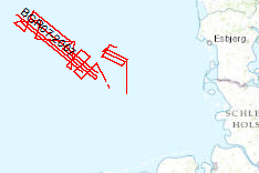
Processed seismic data of Cruise BGR 2007
The previous BGR-cruises with RV AURELIA in 2003 and 2004 and RV HEINCKE in 2005 and RV ALKOR in 2006 were designed to collect a grid of seismic MCS-data which should enable us to get a high-resolution overview over the upper 1-2 s TWT of the sediments of the German North Sea sector. The data format is Society of Exploration Geophysicists SEG Y. The aim of this cruise was a detailed survey in the north westernmost area of the German EEZ (exclusive economic zone), the so-called ‘Entenschnabel’ and additionally a mapping of special glacial structures off Sylt Island. The cruise was subdivided into two Legs. One outreaching additional aim was to extend the results from the previous cruises for the Late Tertiary and Quaternary sedimentary evolution into the ‘Entenschnabel’-area which was virtually unexplored by systematic shallow high-resolution seismics. During Leg 1 the BGR high-resolution multichannel seismic reflection system consisting of a GI-Gun (0.8 l) and a 500 m streamer with 36 channels and a shallow swath bathymetric system, type SIMRAD EM1200 by Kongsberg, Bergen, Norway were used. While the BGR-seismic system was used to observe the shallow subsurface down to 2 s TWT penetration depth, the swath bathymetric system was used to identify possible pockmark locations as well as sampling positions for the deployment of the BGR vibration corer during the succeeding Leg 2. All seismic records were processed onboard for the quality control and for a first interpretation loaded into GEOQUEST.
Simple
- Alternate title
-
BGR07 2007
- Date (Creation)
- 2007-07-28
- Citation identifier
- 15ef5959-adb4-45fa-ba10-bc76f8c1c1e7
- Status
- Completed
-
GEMET - INSPIRE themes, version 1.0
-
-
geology
-
Geologie
-
-
GEMET - Concepts, version 2.4
-
-
geophysics
-
Geophysik
-
raw material
-
Rohstoff
-
marine geology
-
Meeresgeologie
-
- Theme
-
-
seismics
-
Seismik
-
two-dimensional seismic reflection
-
zweidimensionale Reflektionsseismik
-
MSSP
-
GeolDG
-
- Place
-
-
North Sea
-
Nordsee
-
German EEZ
-
Deutsche AWZ
-
- Access constraints
- Other restrictions
- Other constraints
- Es gelten keine Zugriffsbeschränkungen
- Use constraints
- Other restrictions
- Other constraints
-
Allgemeine Geschäftsbedingungen, siehe https://www.bgr.bund.de/AGB - General terms and conditions, see https://www.bgr.bund.de/AGB_en . Die bereitgestellten Informationen sind bei Weiterverwendung wie folgt zu zitieren: Datenquelle: BGR07, (c) BGR, Hannover, 2007
- Spatial representation type
- Vector
- Language
- English
- Character set
- UTF8
- Topic category
-
- Geoscientific information
))
- Unique resource identifier
- EPSG:4326
- Distribution format
-
-
Shapefile
(
n/a
)
-
Shapefile
(
n/a
)
- Transfer size
- 1
- OnLine resource
-
BGR07 2007 (Shapefile)
BGR07 2007 im Format ESRI Shape
- OnLine resource
- Profile BGR07-101
- OnLine resource
- Profile BGR07-102
- OnLine resource
- Profile BGR07-103
- OnLine resource
- Profile BGR07-104
- OnLine resource
- Profile BGR07-105
- OnLine resource
- Profile BGR07-106
- OnLine resource
- Profile BGR07-107
- OnLine resource
- Profile BGR07-107A
- OnLine resource
- Profile BGR07-108
- OnLine resource
- Profile BGR07-109
- OnLine resource
- Profile BGR07-110
- OnLine resource
- Profile BGR07-111
- OnLine resource
- Profile BGR07-112
- OnLine resource
- Profile BGR07-113
- OnLine resource
- Profile BGR07-114
- OnLine resource
- Profile BGR07-115
- OnLine resource
- Profile BGR07-116
- OnLine resource
- Profile BGR07-117
- OnLine resource
- Profile BGR07-117A
- OnLine resource
- Profile BGR07-118
- OnLine resource
- Profile BGR07-119
- OnLine resource
- Profile BGR07-120
- OnLine resource
- Profile BGR07-121
- OnLine resource
- Profile BGR07-122
- OnLine resource
- Profile BGR07-122A
- OnLine resource
- Profile BGR07-123
- OnLine resource
- Profile BGR07-124
- OnLine resource
- Profile BGR07-125
- OnLine resource
- Profile BGR07-126
- OnLine resource
- Profile BGR07-127
- OnLine resource
- Profile BGR07-128
- OnLine resource
- Profile BGR07-129
- OnLine resource
- Profile BGR07-130
- OnLine resource
- Karte im BGR-Geoviewer
- Hierarchy level
- Dataset
Conformance result
- Date (Publication)
- 2010-12-08
- Explanation
-
siehe dazu die angegebene Durchführungsbestimmung
- Statement
-
During the period from 23rd of June to 28th of July 2007 BGR aquired seismic lines in the Central North Sea. All lines are processed (migrated) data.
- File identifier
- b5441f9c-7e10-493d-a6de-3286925546d4 XML
- Metadata language
- English
- Character set
- UTF8
- Parent identifier
-
Marine Seismic Survey Profiles (MSSP)
06a73c56-06a2-40d8-b806-466222b0760d
- Hierarchy level
- Dataset
- Hierarchy level name
-
Geophysik
- Hierarchy level name
-
GeolDG
- Date stamp
- 2025-04-07
- Metadata standard name
-
INSPIRE Metadata Implementing Rules: Technical Guidelines based on EN ISO 19115 and EN ISO 19119
- Metadata standard version
-
n/a
Overviews
Spatial extent
Provided by
