My GeoNetwork catalogue
Prozessierte seismische Daten der Fahrt BGR99 1999
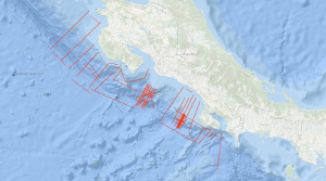
Zwischen dem 08.11.1999 und 02.12.1999 wurde der aktive Kontinentrand vor Costa Rica mit dem Seismik-Schiff Professor Polshkov untersucht. Diese Fahrt hatte drei wissenschaftliche Ziele. Einerseits sollten mehrere Profile senkrecht zum Rand die generelle Variabilität des Akkretionskeils abbilden. In der Nähe des Jaco Scarps sollte ein dichtes Netz seismischer Profile in Verbindung mit einer hochfrequenten seismischen Quelle Informationen über die Gashydrat-Verteilung im Sediment liefern. Im Bereich südlich des Quepos-Plateaus sollten mehrere engmaschige Profile zur Vorbereitung eine ODP-Kampagne dienen – diese wurde 2011 als IOPD Expedition 334 durchgeführt.
Simple
- Alternativtitel
-
BGR99 1999
- Datumsangaben (Erstellung)
- 1999-12-02
- Identifikator
- 313ce6c8-1aed-1ea5-87c5-61c032a1c4bf
- Bearbeitungsstatus
- Abgeschlossen
-
GEMET - INSPIRE themes, version 1.0
-
-
Geologie
-
geology
-
-
GEMET - Concepts, version 2.4
-
-
geophysics
-
Geophysik
-
raw material
-
Rohstoff
-
- Thema
-
-
Marine geology
-
Meeresgeologie
-
Seismics
-
Seismik
-
Two-dimensional seismic reflection
-
zweidimensionale Reflektionsseismik
-
- Ort
-
-
Northeast Pacific Ocean
-
Nordost-Pazifik
-
Costa Rica
-
- Zugriffseinschränkungen
- Benutzerdefinierte Einschränkungen
- Andere Einschränkungen
- Es gelten keine Zugriffsbeschränkungen
- Nutzungseinschränkungen
- Benutzerdefinierte Einschränkungen
- Andere Einschränkungen
-
Allgemeine Geschäftsbedingungen, siehe http://www.bgr.bund.de/AGB - General terms and conditions, see http://www.bgr.bund.de/AGB_en . Die bereitgestellten Informationen sind bei Weiterverwendung wie folgt zu zitieren: Datenquelle: BGR99 1999, (c) BGR, Hannover, 2018
- Räumliche Darstellungsart
- Vektor
- Sprache
- English
- Zeichensatz
- Utf8
- Thematik
-
- Geowissenschaften
))
- Code
- EPSG:4326
- Abgabeformat
-
-
Shapefile
(
n/a
)
-
Shapefile
(
n/a
)
- Transfergrösse
- 2
- Online
-
BGR99 1999 (Shapefile)
BGR99 1999 im Format ESRI Shape
- Online
- Profile BGR99-01
- Online
- Profile BGR99-02
- Online
- Profile BGR99-03
- Online
- Profile BGR99-04
- Online
- Profile BGR99-05
- Online
- Profile BGR99-06
- Online
- Profile BGR99-07
- Online
- Profile BGR99-08
- Online
- Profile BGR99-09
- Online
- Profile BGR99-10
- Online
- Profile BGR99-11
- Online
- Profile BGR99-12
- Online
- Profile BGR99-12A
- Online
- Profile BGR99-13
- Online
- Profile BGR99-14
- Online
- Profile BGR99-15
- Online
- Profile BGR99-16
- Online
- Profile BGR99-16A
- Online
- Profile BGR99-17
- Online
- Profile BGR99-18
- Online
- Profile BGR99-19
- Online
- Profile BGR99-20
- Online
- Profile BGR99-21
- Online
- Profile BGR99-22
- Online
- Profile BGR99-23
- Online
- Profile BGR99-39
- Online
- Profile BGR99-40
- Online
- Profile BGR99-41
- Online
- Profile BGR99-42
- Online
- Profile BGR99-43
- Online
- Profile BGR99-44
- Online
- Profile BGR99-45
- Online
- Profile BGR99-46
- Online
- Profile BGR99-46A
- Online
- Profile BGR99-47
- Online
- Profile BGR99-47A
- Online
- Profile BGR99-48
- Online
- Profile BGR99-49A
- Online
- Profile BGR99-50
- Online
- Profile BGR99-51
- Online
- Profile BGR99-52
- Online
- Profile BGR99-53
- Online
- Profile BGR99-54
- Online
- Profile BGR99-55
- Online
- Profile BGR99-56
- Online
- Profile BGR99-57
- Online
- Profile BGR99-58
- Online
- Profile BGR99-58A
- Online
- Profile BGR99-59
- Online
- Profile BGR99-60
- Online
- Profile BGR99-61
- Online
- Profile BGR99-62
- Online
- Profile BGR99-63
- Online
- Profile BGR99-64
- Online
- Profile BGR99-65
- Online
- Profile BGR99-66
- Online
- Profile BGR99-67
- Online
- Profile BGR99-68
- Online
- Profile BGR99-69
- Online
- Karte im BGR-Geoviewer
- Bezugsebene
- Datenbestand
Konformitätsergebnis
- Datumsangaben (Publikation)
- 2010-12-08
- Erklärung
-
siehe dazu die angegebene Durchführungsbestimmung
- Erläuterung
-
During the period from 8th November to 2nd December 1999 BGR acquired seismic lines off the Pacific coast of Costa Rica. All lines BGR99-01 to BGR99-23 and BGR99-39 to BGR99-69 consist of stacked data.
- Metadatensatzidentifikator
- b61ec9c1-0d1b-408f-8c13-aedb8a028b75 XML
- Sprache
- English
- Zeichensatz
- Utf8
- Identifikator des übergeordneten Metadatensatzes
-
Marine Seismic Survey Profiles (MSSP)
06a73c56-06a2-40d8-b806-466222b0760d
- Hierarchieebene
- Datenbestand
- Bezeichnung der Hierarchieebene
-
Geophysik
- Datum
- 2023-11-16
- Bezeichnung des Metadatenstandards
-
INSPIRE Metadata Implementing Rules: Technical Guidelines based on EN ISO 19115 and EN ISO 19119
- Version des Metadatenstandards
-
n/a