 My GeoNetwork catalogue
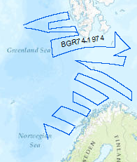
Processed seismic data of Cruise BGR 1974
Reconnaissance surveys were carried out in 1974 within the framework of the BGR program "Geoscientific studies in the North Atlantic". The areas covered were the continental margin of Spitsbergen, the Barents Sea and the Norwegian continental margin. On the R/V LONGVA (10th August, 1974 - 10th September, 1974) multichannel seismic measurements were carried out on 40 lines with a total length of 8,091 km. The data format is Society of Exploration Geophysicists SEG Y.
Simple
- Alternate title
-
BGR 1974
- Date (Creation)
- 1974-09-10
- Citation identifier
- fd17dde2-e3dc-41e0-9559-e84d80330efa
- Status
- Completed
-
GEMET - INSPIRE themes, version 1.0
-
-
geology
-
Geologie
-
-
GEMET - Concepts, version 2.4
-
-
geophysics
-
Geophysik
-
raw material
-
Rohstoff
-
marine geology
-
Meeresgeologie
-
- Theme
-
-
seismics
-
Seismik
-
two-dimensional seismic reflection
-
zweidimensionale Reflektionsseismik
-
MSSP
-
- Place
-
-
North Atlantic
-
Nordatlantik
-
Barents Sea
-
Barentssee
-
- Access constraints
- Other restrictions
- Other constraints
- Es gelten keine Zugriffsbeschränkungen
- Use constraints
- Other restrictions
- Other constraints
-
Allgemeine Geschäftsbedingungen, siehe https://www.bgr.bund.de/AGB - General terms and conditions, see https://www.bgr.bund.de/AGB_en . Die bereitgestellten Informationen sind bei Weiterverwendung wie folgt zu zitieren: Datenquelle: BGR 74, (c) BGR, Hannover, 1974
- Spatial representation type
- Vector
- Language
- English
- Character set
- UTF8
- Topic category
-
- Geoscientific information
))
- Unique resource identifier
- EPSG:4326
- Distribution format
-
-
Shapefile
(
n/a
)
-
Shapefile
(
n/a
)
- Transfer size
- 1
- OnLine resource
-
BGR 1974 (Shapefile)
BGR 1974 im Format ESRI Shape
- OnLine resource
- Profile BGR74-01
- OnLine resource
- Profile BGR74-02
- OnLine resource
- Profile BGR74-03
- OnLine resource
- Profile BGR74-04
- OnLine resource
- Profile BGR74-05
- OnLine resource
- Profile BGR74-06
- OnLine resource
- Profile BGR74-06A
- OnLine resource
- Profile BGR74-07
- OnLine resource
- Profile BGR74-08
- OnLine resource
- Profile BGR74-09
- OnLine resource
- Profile BGR74-10
- OnLine resource
- Profile BGR74-11
- OnLine resource
- Profile BGR74-12
- OnLine resource
- Profile BGR74-12B
- OnLine resource
- Profile BGR74-13
- OnLine resource
- Profile BGR74-14
- OnLine resource
- Profile BGR74-14B
- OnLine resource
- Profile BGR74-15
- OnLine resource
- Profile BGR74-16
- OnLine resource
- Profile BGR74-16B
- OnLine resource
- Profile BGR74-16C
- OnLine resource
- Profile BGR74-17
- OnLine resource
- Profile BGR74-17B
- OnLine resource
- Profile BGR74-18
- OnLine resource
- Profile BGR74-19
- OnLine resource
- Profile BGR74-20
- OnLine resource
- Profile BGR74-21
- OnLine resource
- Profile BGR74-22
- OnLine resource
- Profile BGR74-23
- OnLine resource
- Profile BGR74-24
- OnLine resource
- Profile BGR74-25
- OnLine resource
- Profile BGR74-25B
- OnLine resource
- Profile BGR74-26
- OnLine resource
- Profile BGR74-27
- OnLine resource
- Profile BGR74-27B
- OnLine resource
- Profile BGR74-28
- OnLine resource
- Profile BGR74-29
- OnLine resource
- Profile BGR74-30
- OnLine resource
- Profile BGR74-31
- OnLine resource
- Profile BGR74-32
- OnLine resource
- Karte im BGR-Geoviewer
- Hierarchy level
- Dataset
Conformance result
- Date (Publication)
- 2010-12-08
- Explanation
-
siehe dazu die angegebene Durchführungsbestimmung
- Statement
-
During the period from 10th of August to 10th of September 1974 BGR aquired seismic lines in the North Atlantic. The lines BGR74-01, BGR74-02, BGR74-03, BGR74-04, BGR74-05, BGR74-06, BGR74-07, BGR74-08, BGR74-09, BGR74-10, BGR74-11, BGR74-12, BGR74-12B, BGR74-14, BGR74-14B, BGR74-15, BGR74-16, BGR74-16B, BGR74-16C, , BGR74-17, BGR74-17B, BGR74-18, BGR74-19, BGR74-20, BGR74-21, BGR74-22, BGR74-23, BGR74-25, BGR74-25B, BGR74-26, BGR74-27, BGR74-27B, BGR74-29, BGR74-30, BGR74-31, BGR74-32 are processed (stack) data. The lines BGR74-06A, BGR74-13, BGR74-24, BGR74-28 are raw data.
- File identifier
- bab56949-fd5f-46a0-ac7d-f60fb6acce57 XML
- Metadata language
- English
- Character set
- UTF8
- Parent identifier
-
Marine Seismic Survey Profiles (MSSP)
06a73c56-06a2-40d8-b806-466222b0760d
- Hierarchy level
- Dataset
- Hierarchy level name
-
Geophysik
- Date stamp
- 2025-04-07
- Metadata standard name
-
INSPIRE Metadata Implementing Rules: Technical Guidelines based on EN ISO 19115 and EN ISO 19119
- Metadata standard version
-
n/a
Overviews
Spatial extent
Provided by
