 My GeoNetwork catalogue
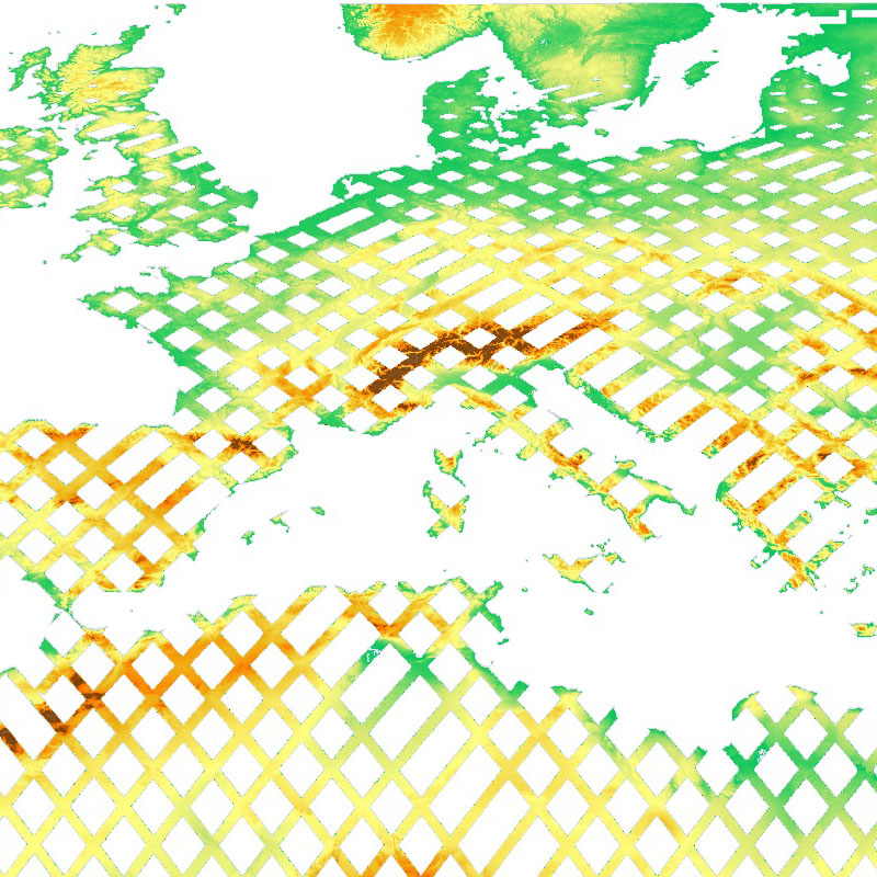
SRTM X-SAR - Elevation Mosaic - Global
The SRTM X-SAR Elevation Mosaic is an aggregation of DLR's SRTM X-SAR DTED files.
The DTED Level-2 files have been generated from Synthetic Aperture Radar (SAR) data acquired by the German-Italian X-band interferometric SAR system during the Shuttle Radar Topography Mission (SRTM) between February 11 and 22, 2000. The X-band system was flown and operated onboard the Space Shuttle Endeavor, along with a NASA C-Band SAR system. The SRTM project page at DLR provides additional information on the SRTM X-band mission ( http://www.dlr.de/eoc/en/desktopdefault.aspx/tabid-5515/9214_read-17716/ ). Further details on the mission in general, the technology, accuracies, and applications are available in http://www2.jpl.nasa.gov/srtm/SRTM_paper.pdf .
The original DTED files have been grouped and mosaicked into 30 x 30 degree tiles. Six out of the total of 48 tiles were empty since they do not contain any DTED files. The resulting 42 tiles are stored as uncompressed GeoTIFF files. The files have been supplemented with nine cubic convolution resampled overviews for fast web delivery.
Simple
- Date (Creation)
- 2010-10-11T17:00:00
- Citation identifier
- https://geoservice.dlr.de/catalogue/srv/metadata/c03846b9-b94b-4dc4-a989-ee58bf7afb5d
- Presentation form
- Digital map
- Purpose
-
The purpose of the SRTM X-SAR Elevation Mosaic is to enable and facilitate access to and visualisation of DLR's SRTM data through standardized web services.
- Status
- Completed
- Maintenance and update frequency
- Not planned
- Theme
-
-
DLR
-
Elevation
-
Space Shuttle
-
STS-99
-
SRTM
-
X-SAR
-
Global
-
inspireidentifiziert
-
-
GEMET - INSPIRE themes, version 1.0
-
-
Höhe
-
- Access constraints
- Other restrictions
- Other constraints
- Es gelten keine Zugriffsbeschränkungen
- Use constraints
- Other restrictions
- Other constraints
-
Nutzungsbedingungen: https://geoservice.dlr.de/resources/licenses/srtm_xsar/DLR_SRTM_XSAR_ReadMe.pdf / Terms of use: https://geoservice.dlr.de/resources/licenses/srtm_xsar/DLR_SRTM_XSAR_ReadMe.pdf
- Use limitation
-
Nutzungseinschränkungen: Das DLR ist nicht haftbar für Schäden, die sich aus der Nutzung ergeben. / Use Limitations: DLR not liable for damage resulting from use.
- Spatial representation type
- Grid
- Denominator
- 50000
- Language
- Deutsch
- Character set
- UTF8
- Topic category
-
- Elevation
))
- Begin date
- 2000-01-11T00:00:00
- End date
- 2000-01-22T23:59:00
- Supplemental Information
-
Units are meters. Heights are stored in 1 meter levels within the WGS84 vertical datum. The NoData value of this dataset is -32767.
- Unique resource identifier
- EPSG:4326
- Number of dimensions
- 3
- Dimension name
- Row
- Dimension size
- 1598400
- Resolution
- 25 m
- Dimension name
- Column
- Dimension size
- 510600
- Resolution
- 25 m
- Dimension name
- Vertical
- Dimension size
- 1
- Resolution
- 1 m
- Cell geometry
- Area
- Transformation parameter availability
- No
- Distribution format
-
-
GeoTIFF
()
-
GeoTIFF
()
- OnLine resource
-
DLR SRTM Webpage
(
WWW:LINK-1.0-http--link
)
Webpage with links and mission descriptions
- OnLine resource
-
srtm_x-sar_dem_mosaic
(
OGC:WMS
)
WMS access to SRTM X-SAR Elevation Mosaic
- OnLine resource
-
srtm_x-sar_dem_mosaic
(
OGC:WCS
)
WCS access to SRTM X-SAR Elevation Mosaic
- OnLine resource
- https://geoservice.dlr.de/eoc/elevation/wms?SERVICE=WMS&REQUEST=GetCapabilities ( OGC:WMS-http-get-capabilities )
- OnLine resource
- https://geoservice.dlr.de/eoc/elevation/wcs?SERVICE=WCS&REQUEST=GetCapabilities ( OGC:WCS-http-get-capabilities )
- OnLine resource
-
EOC Geoservice Map Context
(
WWW:LINK-1.0-http--link
)
EOC Geoservice Map Context (srtm:x-sar)
- Hierarchy level
- Dataset
Domain consistency
- Measure identification
- INSPIRE / Conformity_001
Conformance result
- Date (Publication)
- 2010-12-08
- Explanation
-
See the referenced specification.
- Pass
- Yes
- Statement
-
Horizontal accuracy (absolute): ±20m 90% circular error
Horizontal accuracy (relative): ±15m 90% circular error
Vertical accuracy (absolute): ±16m 90% linear error
Vertical accuracy (relative): ±6m 90% linear error
- Description
-
Calculation of a list of files that are contained in each 30x30 degree tile of the world grid
- Date / Time
- 2010-07-30T18:00:00
- Description
-
Merging the files from the list into one GeoTIFF file. The following GDAL v1.7.2 command was used: gdal_merge.py -of GTiff -co TFW=YES -co TILED=YES -init -32767 -n -32767
- Date / Time
- 2010-07-31T09:00:00
- Description
-
Calculation of the overviews for each GeoTIFF tile. The following GDAL v1.7.2 command was used: gdaladdo -r cubic GEOTIFF_FILE 4 8 16 32 64 128 256 512 1024
- Date / Time
- 2010-08-01T18:00:00
- File identifier
- c03846b9-b94b-4dc4-a989-ee58bf7afb5d XML
- Metadata language
- Deutsch
- Character set
- UTF8
- Hierarchy level
- Dataset
- Hierarchy level name
-
dataset
- Date stamp
- 2024-06-20T14:12:08
- Metadata standard name
-
ISO 19115-1:2014/19139
- Metadata standard version
-
1.0
Overviews
Spatial extent
Provided by
