 My GeoNetwork catalogue
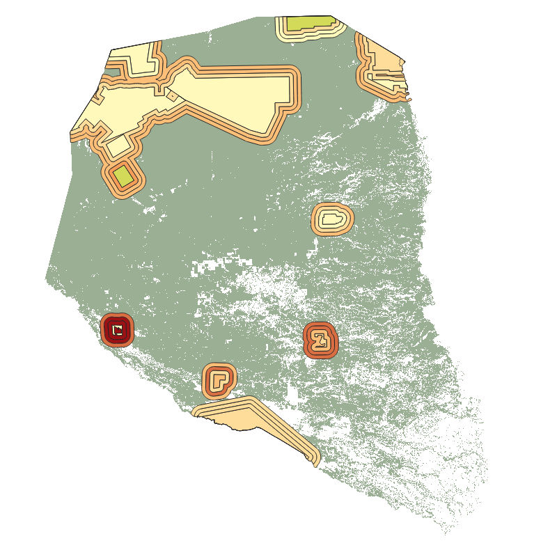
Geo-ForPy - Forest Cover per Protected Area in the Paraguayan Chaco - 2000-2020
This product is a vector file of the protected areas of the Paraguayan Chaco. It contains information on the forest cover within each protected area and a 5, 10, and 15 km buffer zone around these areas, for the years 2000 until 2020. Hence, this product aggregates the information of 21 annual forest maps of the Paraguayan Chaco to the level of protected areas and provides the basis for further analysis as conducted in the following publication: https://doi.org/10.3390/f130100 25
Simple
- Date (Creation)
- 2022-09-27T00:00:00
- Citation identifier
- https://geoservice.dlr.de/catalogue/srv/metadata/d1d97c73-eff4-411b-93d6-f4a30ea05faa
- Presentation form
- Digital map
- Purpose
-
This data set provides the results of a analysis of the forest cover develeopment in the protected areas of the Paraguayan Chaco between 2000 and 2020 and reveals the effectiveness of such protecting zones.
- Status
- Completed
- Maintenance and update frequency
- As needed
-
GEMET - INSPIRE themes, version 1.0
-
-
Land cover
-
- Keywords
-
-
opendata
-
DLR
-
EOC
-
GeoForPy
-
Forest
-
Forest Cover
-
Landsat-5
-
Landsat-7
-
Landsat-8
-
Paraguay
-
random forest
-
protected areas
-
- Use limitation
-
Nutzungseinschränkungen: Das DLR ist nicht haftbar für Schäden, die sich aus der Nutzung ergeben. / Use Limitations: DLR not liable for damage resulting from use.
- Access constraints
- Other restrictions
- Use constraints
- Other restrictions
- Other constraints
-
Nutzungsbedingungen: Lizenz, https://creativecommons.org/licenses/by/4.0/ Terms of use: License, https://creativecommons.org/licenses/by/4.0/
- Other constraints
-
{"id": "cc-by-4.0",
"name": "Creative-Commons - Attribution 4.0 International (CC BY 4.0)",
"url": " http://dcat-ap.de/def/licenses/cc-by/4.0 ",
"quelle": "Copyright DLR (2022)"}
- Spatial representation type
- Grid
- Denominator
- 60000
- Language
- English
- Character set
- UTF8
- Topic category
-
- Biota
))
- Begin date
- 2000-01-01T00:00:00
- End date
- 2020-12-31T23:59:59
- Unique resource identifier
- EPSG:32721 - WGS 84 / UTM zone 21S
- Distribution format
-
-
Geopackage
()
-
Geopackage
()
- OnLine resource
-
PROTECTED_AREAS_FOREST_PRY
(
OGC:WMS
)
WMS Access: Forest cover per protected area in the Paraguayan Chaco 2000 - 2020
- OnLine resource
- HTTP download Geo-ForPy - Paraguayan Chaco, 2000-2020 ( WWW:LINK-1.0-http--link )
- OnLine resource
-
Geo-ForPy - Deforestration in Latin America and the Paraguayan Chaco
(
WWW:LINK-1.0-http--link
)
Geo-ForPy - project Webpage
- OnLine resource
-
Understanding 34 Years of Forest Cover Dynamics across the Paraguayan Chaco: Characterizing Annual Changes and Forest Fragmentation Levels between 1987 and 2020
(
WWW:LINK-1.0-http--link
)
Article
- Hierarchy level
- Dataset
Domain consistency
- Measure identification
- INSPIRE / Conformity_001
Conformance result
- Date (Publication)
- 2010-12-08
- Explanation
-
See the referenced specification.
- Pass
- Yes
- Statement
-
This data set provides 21 years of forest cover losses in the protected areas and surrounding buffer zones in the Paraguayan Chaco. All information is given in square meter. The forest cover per protected area/buffer zone was derivated from the forest masks (2000 – 2020) which are a product of the Geo-ForPy project.
- Description
-
Processing:
Overlapping buffer zones of two or more protected areas were merged to one common buffer zone. To calculate the forest cover per protected area/buffer zone, the shape file was intersected with the forest areas of the annual forest masks and the area of intersection was calclulated.
Quality Assurance:
The underlying forest masks have overall accuracies between 85% and 97%. Missclassifications directly affect the calculated forest area.
- File identifier
- d1d97c73-eff4-411b-93d6-f4a30ea05faa XML
- Metadata language
- English
- Character set
- UTF8
- Hierarchy level
- Dataset
- Hierarchy level name
-
Dataset
- Date stamp
- 2024-06-20T13:07:17
- Metadata standard name
-
ISO 19115-1:2014/19139
Overviews
Spatial extent
Provided by
