 My GeoNetwork catalogue
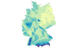
Grids of the multi-annual means of precipitation height over Germany
Grids are derived from DWD stations and legally and qualitatively equivalent partner stations in Germany.
Simple
- Date (Publication)
- 2019-01-02
- Citation identifier
- https://registry.gdi-de.org/id/de.bund.dwd/de.dwd.klm.cdc.general.GRD_DEU_P30Y_RR_P1Y
- Presentation form
- Digital map
- Purpose
-
The climate reference maps are produced for the climatological reference periods to support climatological analysis.
- Maintenance and update frequency
- Not planned
- Update scope
- Dataset
-
WMO_CategoryCode
-
-
meteorology
-
-
GEMET - INSPIRE themes, version 1.0
-
-
Atmospheric conditions
-
Meteorological geographical features
-
precipitation
-
- Keywords
-
-
climate reference period
-
climate reference map
-
multi-annual mean
-
gridded data based on station data
-
- Keywords
-
-
inspireidentifiziert
-
- Place
-
-
Germany
-
- Use constraints
- Intellectual property rights
- Use limitation
-
Use limitations: No limitations apply.
- Use constraints
- Other restrictions
- Other constraints
-
Use constraints: The Ordinance to Determine the Conditions for Use for the Provision of Spatial Data of the Federation ("Verordnung zur Festlegung der Nutzungsbestimmungen für die Bereitstellung von Geodaten des Bundes" - GeoNutzV) shall apply, for details turn to " http://www.geodatenzentrum.de/docpdf/geonutzv_eng.pdf " and " http://www.dwd.de/EN/service/copyright/copyright_artikel.html ".
- Access constraints
- Other restrictions
- Other constraints
- Access constraints: No conditions apply.
- Classification
- Unclassified
- Spatial representation type
- Grid
- Distance
- 1.001 km
- Denominator
- 1000000
- Language
- Deutsch
- Topic category
-
- Climatology, meteorology, atmosphere
))
- Begin date
- 1961-01-01
- End date
- 1990-12-31
- Reference system identifier
- http://www.opengis.net/def/crs/EPSG/0/31467
- Reference system identifier
- http://www.opengis.net/def/crs/EPSG/0/3034
- Distribution format
-
-
OGC-WMS Web Map Service
(
2.0.0
)
-
ascii-grid
(
)
-
OGC-WMS Web Map Service
(
2.0.0
)
+49 (0) 69 8062-4499
http://www.dwd.de
- OnLine resource
-
WMS Capabilities Dokument für GRD_DEU_P30Y_RR_P1Y
(
OGC:WMS-1.3.0-http-get-capabilities
)
Zugriff auf das WMS Capabilities Dokument für GRD_DEU_P30Y_RR_P1Y
- OnLine resource
-
DWD OpenData-Server: Verzeichnis der Klimareferenzkarten
(
WWW:LINK-1.0-http--link
)
Directory with grid files of climate
reference maps on the OpenData-Server of the DWD (free access). Please take
note of the locally available dataset descriptions!
- Hierarchy level
- Dataset
Conformance result
- Date (Publication)
- 2010-12-08
- Explanation
-
validated with http://inspire.ec.europa.eu/validator against TG 2.0
- Pass
- Yes
- Statement
-
The grids for 1961-1990 are based on homogenized station data [Herzog und Müller-Westermeier, 1998]. The 30 year averages were calculated for or each calendar month of the year before the spatial interpolation. The gridding method is based on height regression and Inverse Distance Weight (IDW), see Müller-Westermeier, 1995: The station density allows for a linear regression between topographic height and climatological parameters within a region, and varies somewhat between the regions in Germany [Maier undMüller-Westermeier, 2010]. The regression coefficients were determined seperately for each month, based on the monthly means recorded 1951-1980.
Using these interpolated regression coefficients, in a first step, the station values are reduced to the reference height and attributed to the grid cells. In case several stations refer to a grid cell, the mean was taken.
In a second step, the values at reference height were interpolated horizontally to cover the grid (weighted with the inverse square distance).
Finally, in a third step, the values at reference height are transformed to values corresponding to the topographic elevation using again the spatially variable regression function. This is done with the DWD digital topographic height model.When grid cells contain a station,the value of the latter is simply interpolated vertically to the height of the grid cell.
- File identifier
- de.dwd.klm.cdc.general.GRD_DEU_P30Y_RR_P1Y XML
- Metadata language
- Deutsch
- Character set
- UTF8
- Hierarchy level
- Dataset
- Hierarchy level name
-
DWD-Geowebdienste-Layer
- Date stamp
- 2019-11-22T08:46:38
- Metadata standard name
-
ISO 19115-2 Geographic information — Metadata — Part 2: Extensions for imagery and gridded data
- Metadata standard version
-
ISO 19115-2:2009-02-15
+49 (0) 69 8062-4162
www.dwd.de
Overviews
Spatial extent
Provided by
