 My GeoNetwork catalogue
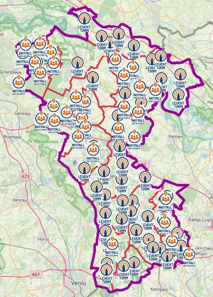
Notfallanlaufstellen Kreis Kleve
Im Falle eines Notfalls, wie etwa eines langanhaltenden und flächendeckenden Stromausfalls in folge dessen es zu einem Telekommunikationsausfalls kommt, gibt es in Städten und Kommunen, Anlaufstellen für alle Hilfesuchenden Bürgerinnen und Bürger.
Es handelt sich unter anderem um Leuchttürme, welche mit Notstrom versorgt werden und als Verbindungsstellen zwischen den Hilfesuchenden und den Leitstellen fungieren.
Notfall-Infopunkte dienen den Bürgerinnen und Bürgern als Informationsquelle.
Sollte es zum Ausfall der Notrufnummern kommen, dienen unter anderem die personell besetzten Feuerwehrgerätehäuser als Notrufstellen für die Bevölkerung.
Es handelt sich um keine dauerhafte Einrichtungen und werden von den Städten und Gemeinden bei Bedarf im Fall eines Notfalls besetzt.
Simple
- Date (Publication)
- 2023-06-30T00:00:00.000+02:00
- Citation identifier
- https://registry.gdi-de.org/id/de.nw/8a135637-656c-4553-a188-a5eca9b1251e
+49 2821 85-500
https://www.kreis-kleve.de
- Maintenance and update frequency
- As needed
- Update scope
- Dataset
- Keywords
-
-
Kreis Kleve
-
Bedburg-Hau
-
Emmerich am Rhein
-
Emmerich
-
Geldern
-
Goch
-
Issum
-
Kalkar
-
Kerken
-
Wallfahrtsstadt Kevelaer
-
Kevelaer
-
Kranenburg
-
Kleve
-
Rees
-
Rheurdt
-
Straelen
-
Uedem
-
Wachtendonk
-
Weeze
-
NW
-
NRW
-
Nordrhein-Westfalen
-
Notfallanlaufstellen
-
Notfall
-
Leuchttürme
-
Leuchtturm
-
Blackout
-
05154
-
Anlaufstelle
-
Notfall-Infopunkt
-
Notfallinfopunkt
-
- Use constraints
- Other restrictions
- Other constraints
-
Open Data Commons Open Database License (ODbL)
- Other constraints
-
{"id":"odbl","name":"Open Data Commons Open Database License (ODbL)","url":" https://www.opendefinition.org/licenses/odc-odbl","quelle":""}
- Other constraints
-
© OpenStreetMap-Mitwirkende
- Other constraints
-
Quellenvermerk: https://www.openstreetmap.org/copyright
- Access constraints
- Other restrictions
- Other constraints
- Es gelten keine Zugriffsbeschränkungen
- Language
- Deutsch
- Topic category
-
- Health
- Society
- Utilities communication
Extent
- Extent type code
- Yes

))
- Extent type code
- Yes
- Geographic identifier
- Kreis Kleve, Nordrhein-Westfalen, Deutschland (administrative)
- Unique resource identifier
- EPSG 25832: ETRS89 / UTM Zone 32N
- Distribution format
-
- OnLine resource
- WFS Notfallanlaufstellen KLE KR VIE WES
- OnLine resource
- WMS Notfallanlaufstellen KLE KR VIE WES
- Hierarchy level
- Dataset
- Statement
-
von kommunaler Instanz gemeldet
- File identifier
- e2022e21-cf92-4a35-bda5-4f0678d1c0ff XML
- Metadata language
- Deutsch
- Character set
- UTF8
- Parent identifier
-
Notfallanlaufstellen KLE KR VIE WES
e262b787-2bf0-4237-8097-e6637918c73a
- Hierarchy level
- Dataset
- Date stamp
- 2025-07-03
- Metadata standard name
-
ISO19115
- Metadata standard version
-
2003/Cor.1:2006
Overviews
Spatial extent

Provided by
