 My GeoNetwork catalogue
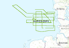
Processed seismic data of Cruise AUR 2003
The late Tertiary and Quaternary development of the German EEZ was systematically inverstigated by seismic profiling. The data format is Society of Exploration Geophysicists SEG Y. For that survey the privately owned motor vessel AURELIA was chartered for a period of 24 days from the 16th of September to 10th of October 2003. A more or less equidistant E-W and N-S grid of profiles with a length of 2500 km was surveyed by high-resolution multichannel seismic system. A 0.82 litre GI-Gun was employed every 12.5 m and the reflected signals were recorded by a 300 m long streamer. Simultaneously a deep-towed HUNTEC-Boomer or a GEO-Sparker was run (150km/620km). All seismic records were processed onboard for the quality control and for a first interpretation.
Simple
- Alternate title
-
AUR03 2003
- Date (Creation)
- 2003-10-10
- Citation identifier
- d23d0398-db75-41f0-af70-cb1c15bb0b4a
- Status
- Completed
-
GEMET - INSPIRE themes, version 1.0
-
-
Geologie
-
geology
-
-
GEMET - Concepts, version 2.4
-
-
geophysics
-
Geophysik
-
raw material
-
Rohstoff
-
- Theme
-
-
Marine geology
-
Meeresgeologie
-
Seismics
-
Seismik
-
Two-dimensional seismic reflection
-
zweidimensionale Reflektionsseismik
-
MSSP
-
GeolDG
-
- Place
-
-
North Sea
-
Nordsee
-
German EEZ
-
Deutsche AWZ
-
- Access constraints
- Other restrictions
- Other constraints
- Es gelten keine Zugriffsbeschränkungen
- Use constraints
- Other restrictions
- Other constraints
-
Allgemeine Geschäftsbedingungen, siehe https://www.bgr.bund.de/AGB - General terms and conditions, see https://www.bgr.bund.de/AGB_en . Die bereitgestellten Informationen sind bei Weiterverwendung wie folgt zu zitieren: Datenquelle: AUR03, (c) BGR, Hannover, 2003
- Spatial representation type
- Vector
- Language
- English
- Character set
- UTF8
- Topic category
-
- Geoscientific information
))
- Unique resource identifier
- EPSG:4326
- Distribution format
-
-
Shapefile
(
n/a
)
-
Shapefile
(
n/a
)
- Transfer size
- 1
- OnLine resource
-
AUR03 2003 (Shapefile)
AUR03 2003 im Format ESRI Shape
- OnLine resource
- Profile AUR03-01
- OnLine resource
- Profile AUR03-02
- OnLine resource
- Profile AUR03-04
- OnLine resource
- Profile AUR03-05
- OnLine resource
- Profile AUR03-06
- OnLine resource
- Profile AUR03-07
- OnLine resource
- Profile AUR03-09
- OnLine resource
- Profile AUR03-11
- OnLine resource
- Profile AUR03-13
- OnLine resource
- Profile AUR03-14
- OnLine resource
- Profile AUR03-15
- OnLine resource
- Profile AUR03-16
- OnLine resource
- Profile AUR03-18
- OnLine resource
- Profile AUR03-19
- OnLine resource
- Profile AUR03-20
- OnLine resource
- Profile AUR03-21
- OnLine resource
- Profile AUR03-22
- OnLine resource
- Profile AUR03-23
- OnLine resource
- Profile AUR03-24
- OnLine resource
- Profile AUR03-25
- OnLine resource
- Profile AUR03-27
- OnLine resource
- Profile AUR03-28
- OnLine resource
- Profile AUR03-29
- OnLine resource
- Profile AUR03-30
- OnLine resource
- Profile AUR03-01a
- OnLine resource
- Profile AUR03-01b
- OnLine resource
- Profile AUR03-04a
- OnLine resource
- Profile AUR03-05a
- OnLine resource
- Profile AUR03-07a
- OnLine resource
- Profile AUR03-15a
- OnLine resource
- Profile AUR03-23a
- OnLine resource
- Profile AUR03-23b
- OnLine resource
- Profile AUR03-03
- OnLine resource
- Profile AUR03-08
- OnLine resource
- Profile AUR03-12
- OnLine resource
- Profile AUR03-17
- OnLine resource
- Profile AUR03-26
- OnLine resource
- Profile AUR03-31
- OnLine resource
- Profile AUR03-32
- OnLine resource
- Profile AUR03-03a
- OnLine resource
- Profile AUR03-03b
- OnLine resource
- Profile AUR03-06a
- OnLine resource
- Profile AUR03-32a
- OnLine resource
- Profile AUR03-10
- OnLine resource
- Karte im BGR-Geoviewer
- Hierarchy level
- Dataset
Conformance result
- Date (Publication)
- 2010-12-08
- Explanation
-
siehe dazu die angegebene Durchführungsbestimmung
- Statement
-
During the period from 16th of September to 10th of October 2003 BGR aquired seismic lines in the Central North Sea. The lines AUR03-01, AUR03-02, AUR03-04, AUR03-05, AUR03-06, AUR03-07, AUR03-09, AUR03-10, AUR03-11, AUR03-13, AUR03-14, AUR03-15, AUR03-16, AUR03-18, AUR03-19, AUR03-20, AUR03-21, AUR03-22, AUR03-23, AUR03-24, AUR03-25, AUR03-27, AUR03-28, AUR03-29, AUR03-30, AUR03-01a, AUR03-01b, AUR03-04a, AUR03-05a, AUR03-07a, AUR03-15a, AUR03-23a and AUR03-23b are processed (stack) data, whereas AUR03-03, AUR03-08, AUR03-12, AUR03-17, AUR03-26, AUR03-31, AUR03-32, AUR03-03a, AUR03-06a and AUR03-32a are raw data.
- File identifier
- e4f5fd8c-8ba7-4be3-a164-f2d2f1b3a02f XML
- Metadata language
- English
- Character set
- UTF8
- Parent identifier
-
Marine Seismic Survey Profiles (MSSP)
06a73c56-06a2-40d8-b806-466222b0760d
- Hierarchy level
- Dataset
- Hierarchy level name
-
Geophysik
- Hierarchy level name
-
GeolDG
- Date stamp
- 2024-03-04
- Metadata standard name
-
INSPIRE Metadata Implementing Rules: Technical Guidelines based on EN ISO 19115 and EN ISO 19119
- Metadata standard version
-
n/a
Overviews
Spatial extent
Provided by
