My GeoNetwork catalogue
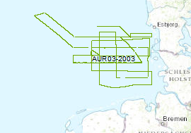
Prozessierte seismische Daten der Fahrt AUR 2003
Die spättertiäre und quartäre Entwicklung des deutschen Nordsee-Sektors wurde mit seismischen Profilen systematisch erkundet. Die Daten liegen im Format der Society of Exploration Geophysicists SEG Y vor. Für die Vermessung wurde das Motorschiff "Aurelia" für 24 Tage vom 16. September bis 10. Oktober gechartert. Ein N-S und W-E gerichtetes, mehr oder weniger gleichmäßiges Profilnetz wurde mit einem hochauflösenden seismischen Multikanalsystem mit einer gesamten Profillänge von 2500 km vermessen. Dabei wurde eine GI-Gun alle 12,5 m eingesetzt und die seismischen Signale durch einen 300 m-langen Streamer aufgezeichnet. Ein tiefgeschleppter Huntec-Boomer und ein Geo-Sparker wurden auf einen Teil der Profile (150 km/620 km) zur Vermessung der quartären Deckschichten benutzt. Alle seismischen Profile wurden zur Qualitätskontrolle und für eine erste Auswertung prozessiert.
Simple
- Alternativtitel
-
AUR03 2003
- Datumsangaben (Erstellung)
- 2003-10-10
- Identifikator
- d23d0398-db75-41f0-af70-cb1c15bb0b4a
- Bearbeitungsstatus
- Abgeschlossen
-
GEMET - INSPIRE themes, version 1.0
-
-
Geologie
-
geology
-
-
GEMET - Concepts, version 2.4
-
-
geophysics
-
Geophysik
-
raw material
-
Rohstoff
-
- Thema
-
-
Marine geology
-
Meeresgeologie
-
Seismics
-
Seismik
-
Two-dimensional seismic reflection
-
zweidimensionale Reflektionsseismik
-
MSSP
-
GeolDG
-
- Ort
-
-
North Sea
-
Nordsee
-
German EEZ
-
Deutsche AWZ
-
- Zugriffseinschränkungen
- Benutzerdefinierte Einschränkungen
- Andere Einschränkungen
- Es gelten keine Zugriffsbeschränkungen
- Nutzungseinschränkungen
- Benutzerdefinierte Einschränkungen
- Andere Einschränkungen
-
Allgemeine Geschäftsbedingungen, siehe https://www.bgr.bund.de/AGB - General terms and conditions, see https://www.bgr.bund.de/AGB_en . Die bereitgestellten Informationen sind bei Weiterverwendung wie folgt zu zitieren: Datenquelle: AUR03, (c) BGR, Hannover, 2003
- Räumliche Darstellungsart
- Vektor
- Sprache
- English
- Zeichensatz
- Utf8
- Thematik
-
- Geowissenschaften
))
- Code
- EPSG:4326
- Abgabeformat
-
-
Shapefile
(
n/a
)
-
Shapefile
(
n/a
)
- Transfergrösse
- 1
- Online
-
AUR03 2003 (Shapefile)
AUR03 2003 im Format ESRI Shape
- Online
- Profile AUR03-01
- Online
- Profile AUR03-02
- Online
- Profile AUR03-04
- Online
- Profile AUR03-05
- Online
- Profile AUR03-06
- Online
- Profile AUR03-07
- Online
- Profile AUR03-09
- Online
- Profile AUR03-11
- Online
- Profile AUR03-13
- Online
- Profile AUR03-14
- Online
- Profile AUR03-15
- Online
- Profile AUR03-16
- Online
- Profile AUR03-18
- Online
- Profile AUR03-19
- Online
- Profile AUR03-20
- Online
- Profile AUR03-21
- Online
- Profile AUR03-22
- Online
- Profile AUR03-23
- Online
- Profile AUR03-24
- Online
- Profile AUR03-25
- Online
- Profile AUR03-27
- Online
- Profile AUR03-28
- Online
- Profile AUR03-29
- Online
- Profile AUR03-30
- Online
- Profile AUR03-01a
- Online
- Profile AUR03-01b
- Online
- Profile AUR03-04a
- Online
- Profile AUR03-05a
- Online
- Profile AUR03-07a
- Online
- Profile AUR03-15a
- Online
- Profile AUR03-23a
- Online
- Profile AUR03-23b
- Online
- Profile AUR03-03
- Online
- Profile AUR03-08
- Online
- Profile AUR03-12
- Online
- Profile AUR03-17
- Online
- Profile AUR03-26
- Online
- Profile AUR03-31
- Online
- Profile AUR03-32
- Online
- Profile AUR03-03a
- Online
- Profile AUR03-03b
- Online
- Profile AUR03-06a
- Online
- Profile AUR03-32a
- Online
- Profile AUR03-10
- Online
- Karte im BGR-Geoviewer
- Bezugsebene
- Datenbestand
Konformitätsergebnis
- Datumsangaben (Publikation)
- 2010-12-08
- Erklärung
-
siehe dazu die angegebene Durchführungsbestimmung
- Erläuterung
-
During the period from 16th of September to 10th of October 2003 BGR aquired seismic lines in the Central North Sea. The lines AUR03-01, AUR03-02, AUR03-04, AUR03-05, AUR03-06, AUR03-07, AUR03-09, AUR03-10, AUR03-11, AUR03-13, AUR03-14, AUR03-15, AUR03-16, AUR03-18, AUR03-19, AUR03-20, AUR03-21, AUR03-22, AUR03-23, AUR03-24, AUR03-25, AUR03-27, AUR03-28, AUR03-29, AUR03-30, AUR03-01a, AUR03-01b, AUR03-04a, AUR03-05a, AUR03-07a, AUR03-15a, AUR03-23a and AUR03-23b are processed (stack) data, whereas AUR03-03, AUR03-08, AUR03-12, AUR03-17, AUR03-26, AUR03-31, AUR03-32, AUR03-03a, AUR03-06a and AUR03-32a are raw data.
- Metadatensatzidentifikator
- e4f5fd8c-8ba7-4be3-a164-f2d2f1b3a02f XML
- Sprache
- English
- Zeichensatz
- Utf8
- Identifikator des übergeordneten Metadatensatzes
-
Marine Seismic Survey Profiles (MSSP)
06a73c56-06a2-40d8-b806-466222b0760d
- Hierarchieebene
- Datenbestand
- Bezeichnung der Hierarchieebene
-
Geophysik
- Bezeichnung der Hierarchieebene
-
GeolDG
- Datum
- 2024-03-04
- Bezeichnung des Metadatenstandards
-
INSPIRE Metadata Implementing Rules: Technical Guidelines based on EN ISO 19115 and EN ISO 19119
- Version des Metadatenstandards
-
n/a