 My GeoNetwork catalogue
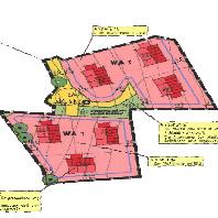
Damflos - Großer Röder 1. Änderung
Bebauungspläne von Damflos:Bebauungsplan der Ortsgemeinde Damflos, Teilgebiet Großer Röder, 1. Änderung,Ortsgemeinde Damflos
Simple
Identification info
- Date (Revision)
- 2025-07-27
-
mapbender.2.registryId
-
-
2f23ed6e-0186-4c2b-8380-748389036509
-
- Keywords
-
-
Bebauungsplan
-
Bebauungspläne
-
Bauleitplan
-
Bauleitpläne
-
Verbandsgemeinde
-
Hermeskeil
-
Ortsgemeinde Damflos
-
infoMapAccessService
-
inspireidentifiziert
-
- Access constraints
- Other restrictions
- Other constraints
- Es gelten keine Zugriffsbeschränkungen
- Use constraints
- Other restrictions
- Other constraints
-
Lizenz: dl-de-zero-2.0 - Datenlizenz Deutschland – Zero – Version 2.0 - https://www.govdata.de/dl-de/zero-2-0
- Other constraints
-
{"id":"dl-de-zero-2.0","name":"Datenlizenz Deutschland \u2013 Zero \u2013 Version 2.0","url":"https:\/\/www.govdata.de\/dl-de\/zero-2-0"}
- Service Type
- view
- Service Version
-
OGC:WMS 1.1.1
))
- Coupling Type
- Tight
Contains Operations
- Operation Name
-
GetCapabilities
- Distributed Computing Platforms
- Web services
- Distribution format
-
- OnLine resource
-
BPLAN.07235014.1.1
(
OGC:WMS-1.1.1-http-get-map
)
Bebauungsplan der Ortsgemeinde Damflos, Teilgebiet Großer Röder, 1. Änderung,Ortsgemeinde Damflos
- Hierarchy level
- Service
- Other
-
Dienst
Conformance result
- Date (Publication)
- 2010-12-08
- Explanation
-
No explanation available
- Pass
- Yes
Conformance result
- Date (Publication)
- 2009-10-20
- Explanation
-
No explanation available
- Pass
- Yes
Conformance result
- Date (Publication)
- 2014-12-11
- Explanation
-
No explanation available
- Pass
- Yes
Conformance result
- Date (Publication)
- 2008-12-04
- Explanation
-
No explanation available
- Pass
- Yes
Conformance result
- Date (Publication)
- 2014-12-11
- Explanation
-
No explanation available
- Pass
- Yes
Conformance result
- Date (Publication)
- 2013-12-10
- Explanation
-
No explanation available
- Pass
- Yes
Conformance result
- Date (Publication)
- 2011-02-05
- Explanation
-
No explanation available
- Pass
- Yes
Conformance result
- Date (Publication)
- 2010-12-08
- Explanation
-
No explanation available
- Pass
- Yes
- File identifier
- ea0cf434-6d2d-0854-fff1-0f2f9e07705c XML
- Metadata language
- Deutsch
- Character set
- UTF8
- Hierarchy level
- Service
- Hierarchy level name
-
Darstellungsdienst
- Date stamp
- 2026-04-26
- Metadata standard name
-
ISO19119
- Metadata standard version
-
2005/PDAM 1
Overviews
Spatial extent
Provided by
