 My GeoNetwork catalogue
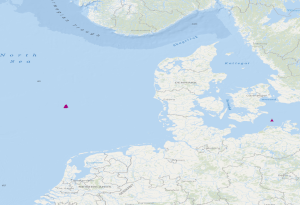
OBS stations of the GEOSTOR project in the German Bight and in the German Baltic Sea
The dataset includes the locations of OBS stations (Ocean Bottom Seismometers) operated in the German Bight during cruise MSM100 with R.V. Maria S. Merian. The time interval from 13.05.2021 to 15.05.2021 has been analysed in a phase without airgun operation for passive recording with 4.5 Hz geophones. Furthermore, the dataset contains locations of 3 broadband OBS systems which were operated during an experiment at the Darss ramp in the German Baltic Sea. The records were analysed in the time interval 23.01.2018 to 01.04.2018.
Simple
- Alternate title
-
GEOSTOR-OBS
- Date (Publication)
- 2024-07-31
- Citation identifier
- https://registry.gdi-de.org/id/de.bund.bgr.csw/62d52001-156a-0f9e-5fa4-a2b87a8af2d4
- Status
- Completed
-
GEMET - INSPIRE themes, version 1.0
-
-
Geology
-
Geologie
-
- Theme
-
-
geophysics
-
Geophysik
-
CO2-Speicherung
-
CO2 Storage
-
Marine geology
-
Meeresgeologie
-
Seismics
-
Seismik
-
Ozeanboden-Seismometer
-
Ocean Bottom Seismometer
-
GeolDG
-
- Place
-
-
Ostsee
-
Baltic Sea
-
German Bight
-
Deutsche Bucht
-
- Access constraints
- Other restrictions
- Other constraints
- Es gelten keine Zugriffsbeschränkungen
- Use constraints
- Other restrictions
- Other constraints
- Dieser Datensatz kann gemäß der Lizenz "Datenlizenz Deutschland Namensnennung 2.0" (https://www.govdata.de/dl-de/by-2-0) genutzt werden.
- Other constraints
-
{ "id": "dl-by-de/2.0", "name": "Datenlizenz Deutschland Namensnennung 2.0", "url": " https://www.govdata.de/dl-de/by-2-0 ", "quelle": "GEOSTOR-OBS" }
- Spatial representation type
- Vector
- Language
- English
- Character set
- UTF8
- Topic category
-
- Geoscientific information
))
- Unique resource identifier
- EPSG:4326
- Distribution format
-
-
online
(
n/a
)
-
ESRI Shape
(
n/a
)
-
online
(
n/a
)
- OnLine resource
- BGR-Projektseite
- OnLine resource
- Daten im Format Shape
- OnLine resource
- Geostor-Webseite
- OnLine resource
- Geostor-Datenkatalog
- Hierarchy level
- Dataset
Conformance result
- Date (Publication)
- 2010-12-08
- Explanation
-
siehe dazu die angegebene Durchführungsbestimmung
- Statement
-
During the period from the 13th May to the 15th May 2021, BGR has operated Ocean Bottom Seismometers (OBS stations) in the German Bight during the project GeoBasis3D. In a phase without airgun operation for passive recording with 4.5 Hz geophones, the data were analysed. Furthermore, experiments with 3 broadband OBS systems have been made at the Darss ramp in the German Baltic Sea. The recorded data were analysed in the time interval from 23.01.2018 to 01.04.2018.
- File identifier
- ead57417-73ac-43ae-a501-614913d5b732 XML
- Metadata language
- English
- Character set
- UTF8
- Hierarchy level
- Dataset
- Hierarchy level name
-
Geophysik
- Hierarchy level name
-
GeolDG
- Date stamp
- 2026-01-13
- Metadata standard name
-
INSPIRE Metadata Implementing Rules: Technical Guidelines based on EN ISO 19115 and EN ISO 19119
- Metadata standard version
-
n/a
Overviews
Spatial extent
Provided by
