 My GeoNetwork catalogue
ConSent-Viewer
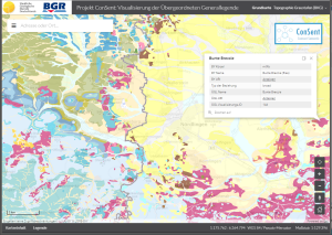
The ConSent Viewer shows the lithostratigraphic units of Bavaria and Baden-Wurttemberg of the superior lithostratigraphic general legend as well as their original data in the scale 1:25.000 resp. 1:50.000. The attributes of the superior legend contain the names, symbols and URIs of the lithostratigraphic units of Bavaria and Baden-Wurttemberg as well as their linkage by means of the SKOS vocabulary. At first, the application shows in small scales the map GK2000 for whole Germany. By zooming in, the maps GK1000 and GÜK250 appear in sequence until the map data of Bavaria and Baden-Wurttemberg are displayed.
Simple
- Alternate title
-
ConSent-Viewer
- Date (Publication)
- 2022-09-07
- Citation identifier
- 01b1593c-b437-bfac-4eda-f8c71fbf3b14
- Status
- On going
- Theme
-
-
Geologie
-
Geology
-
Lithologie
-
Lithology
-
Stratigraphie
-
Stratigraphy
-
- Place
-
-
Bayern
-
Bavaria
-
Baden-Württemberg
-
Baden-Wurttemberg
-
- Access constraints
- Other restrictions
- Other constraints
- Es gelten keine Zugriffsbeschränkungen
- Use constraints
- Other restrictions
- Other constraints
-
Allgemeine Geschäftsbedingungen, siehe https://www.bgr.bund.de/AGB - General terms and conditions, see https://www.bgr.bund.de/AGB_en . Die bereitgestellten Informationen sind bei Weiterverwendung wie folgt zu zitieren: Datenquelle: ConSent-Viewer, (c) BGR, Hannover, 2022
- Language
- Deutsch
- Character set
- UTF8
- Topic category
-
- Geoscientific information
))
- Distribution format
-
-
Webapplication
(
n/a
)
-
Webapplication
(
n/a
)
- OnLine resource
- Start der ConSent-Anwendung
- OnLine resource
- Informationsseite der BGR zum 3D-Viewer
- Hierarchy level
- application
- Statement
-
Im ConSent-Projekt wurde zunächst für die Länder Bayern und Baden-Württemberg eine Übergeordnete Lithostratigraphische Generallegende für die Ausgangsmaßstäbe 1:25.000 bzw. 1:50.000 erarbeitet und mittels des SKOS-Vokabulars mit den Originallegenden dieser Länder
verknüpft.
Bereitstellung und Pflege des ConSent-Viewers erfolgt durch den Bereich Geodatenmanagement der Bundesanstalt für Geowissenschaften und Rohstoffe (BGR)
- File identifier
- eb44f08c-1307-4627-817b-1c56c2648530 XML
- Metadata language
- Deutsch
- Character set
- UTF8
- Hierarchy level
- application
- Hierarchy level name
-
Geologie
- Date stamp
- 2026-01-13
- Metadata standard name
-
INSPIRE Metadata Implementing Rules: Technical Guidelines based on EN ISO 19115 and EN ISO 19119
- Metadata standard version
-
n/a
Overviews
Spatial extent
Provided by
