 My GeoNetwork catalogue
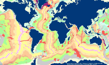
Geologische Übersichtskarte des Meeresbodens weltweit (abgedeckt) (seafloorgeol)
Die Übersichtskarte der Geologie des Meeresbodens weltweit (seafloorgeol) zeigt die weltweite Verbreitung der Festgesteine des Meeresbodens, den Ozeanischen Rücken, die Grenzen der Festlandsockel und Kontinentalabhänge, sowie weitere geologische off-shore Merkmale. Sedimentäre Ablagerungen sind nicht dargestellt. Die Karte basiert auf Auszügen aus Bouysse et al. (2010) © CGMW, sowie Bryan & Ernst (2008) unter Nutzung der Esri Basemap, HERE, Garmin, FAO, NOAA, USGS, © OpenStreetMap contributors and the GIS User Community.
Simple
- Alternate title
-
seafloorgeol
-
Datumsangaben (Publikation)Date (Publication)
- 2022-05-18
- Edition
-
1. Edition
-
IdentifikatorCitation identifier
- 81cdde56-db4e-a35a-ff3f-dce6053cd3ba
-
BearbeitungsstatusStatus
-
AbgeschlossenCompleted
-
GEMET - INSPIRE themes, version 1.0
-
-
Geologie
-
Geology
-
-
OrtPlace
-
-
world
-
-
ThemaTheme
-
-
seafloor geology
-
off-shore
-
bedrock
-
map
-
GeolDG
-
-
ZugriffseinschränkungenAccess constraints
-
Benutzerdefinierte EinschränkungenOther restrictions
- Other constraints
- Es gelten keine Zugriffsbeschränkungen
-
NutzungseinschränkungenUse constraints
-
Benutzerdefinierte EinschränkungenOther restrictions
- Other constraints
-
Allgemeine Geschäftsbedingungen, s. https://www.bgr.bund.de/agb - General Terms and Conditions, s. https://www.bgr.bund.de/agb_en
-
Räumliche DarstellungsartSpatial representation type
-
VektorVector
-
MassstabszahlDenominator
- 70000000
-
SpracheLanguage
- Deutsch
-
ZeichensatzCharacter set
-
Utf8UTF8
-
ThematikTopic category
-
-
GeowissenschaftenGeoscientific information
-
))
- Unique resource identifier
- EPSG:3857
-
AbgabeformatDistribution format
-
-
WMS
(
1.3.0
)
-
WMS
(
1.3.0
)
-
OnlineOnLine resource
- Karte im BGR-Geoviewer
-
OnlineOnLine resource
-
Map in shp format
Map in ESRI Shape format
-
BezugsebeneHierarchy level
-
DatenbestandDataset
Konformitätsergebnis
Conformance result
-
Datumsangaben (Publikation)Date (Publication)
- 2010-12-08
- Explanation
-
siehe dazu die angegebene Durchführungsbestimmung
- Statement
-
Map based on extracts from Bouysse et al. (2010) © CGMW, and Bryan & Ernst (2008), using the Esri Basemap, HERE, Garmin, FAO, NOAA, USGS, © OpenStreetMap contributors and the GIS User Community Bouysse, P. et al (2010): Geological Map of the World. Commission of the Bryan, S. E. and Ernst R. E., 2008. Revised definition of Large Igneous Provinces (LIPs), Elsevier, Earth Science Review 86
-
MetadatensatzidentifikatorFile identifier
- eced4cf0-b4f4-48bb-8f82-37c0f5a33311 XML
-
SpracheMetadata language
- English
-
ZeichensatzCharacter set
-
Utf8UTF8
-
HierarchieebeneHierarchy level
-
DatenbestandDataset
- Hierarchy level name
-
Geologie
- Hierarchy level name
-
GeolDG
-
DatumDate stamp
- 2025-01-20
- Metadata standard name
-
INSPIRE Metadata Implementing Rules: Technical Guidelines based on EN ISO 19115 and EN ISO 19119
- Metadata standard version
-
n/a
Overviews
Spatial extent
Provided by
