 My GeoNetwork catalogue
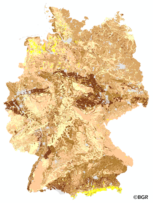
Effective rooting depth of soils in Germany
The map of the effective rooting depth gives an overview of the rooting capacity of German soils. The effective rooting depth is the size of the soil reservoir that the plant can reach to get water in years of drought. The effective rooting depth is determined by both crop and soil properties. The rooting depth is derived from profile data of the landuse stratified soil map of Germany at scale 1:1,000,000. The method is taken from Bodenkundliche Kartieranleitung KA4 (1994) and is documented in the Methoden-WIKI of the FISBo BGR. The land use information is derived from the CORINE Land Cover data set (2006).
Simple
- Alternate title
-
We1000_250
- Date (Creation)
- 2014-06-20
- Date (Publication)
- 2015-08-03
- Edition
-
Version 1.0
- Citation identifier
- c166fbf0-ab24-448b-bf1d-467d37c8bea0
- Status
- Completed
-
GEMET - Concepts, version 2.4
-
-
Boden
-
Bodenkarte
-
-
GEMET - INSPIRE themes, version 1.0
-
-
Boden
-
Soil
-
-
SGD-Liste
-
-
effektive Durchwurzelungstiefe
-
-
Freies Schlagwort
-
-
Gründigkeit
-
Mächtigkeit
-
Bodentiefe
-
- Place
-
-
Bundesrepublik Deutschland
-
- Access constraints
- Other restrictions
- Other constraints
- Es gelten keine Zugriffsbeschränkungen
- Use constraints
- Other restrictions
- Other constraints
-
Allgemeine Geschäftsbedingungen, siehe https://www.bgr.bund.de/AGB - General terms and conditions, see https://www.bgr.bund.de/AGB_en . Die bereitgestellten Informationen sind bei Weiterverwendung wie folgt zu zitieren: Datenquelle: We1000_250 V1.0, (c) BGR, Hannover, 2015.
- Spatial representation type
- Grid
- Denominator
- 1000000
- Language
- Deutsch
- Character set
- UTF8
- Topic category
-
- Geoscientific information
))
- Geographic identifier
- Regionalschlüssel / 000000000000
- Unique resource identifier
- EPSG:3034
- Distribution format
-
-
georef. TIFF
(
n/a
)
-
georef. TIFF
(
n/a
)
- Transfer size
- 4
- OnLine resource
-
We1000_250 (georef. TIFF)
We1000_250 im Format georeferenziertes TIFF
- OnLine resource
- Website zum Thema
- OnLine resource
- Karte im BGR-Geoviewer
- Hierarchy level
- Dataset
Conformance result
- Date (Publication)
- 2010-12-08
- Explanation
-
siehe dazu die angegebene Durchführungsbestimmung
- Statement
-
Bodendaten aus BÜK1000N V2.31 (BGR), Landnutzungsdaten aus CORINE Land Cover 2006 (UBA/DLR).
- File identifier
- edcd248c-2781-4108-a437-2a700908887e XML
- Metadata language
- Deutsch
- Character set
- UTF8
- Hierarchy level
- Dataset
- Hierarchy level name
-
Boden
- Date stamp
- 2025-03-12
- Metadata standard name
-
INSPIRE Metadata Implementing Rules: Technical Guidelines based on EN ISO 19115 and EN ISO 19119
- Metadata standard version
-
n/a
Overviews
Spatial extent
Provided by
