 My GeoNetwork catalogue
GIS data set of the z2Na primary thickness in the North German Basin
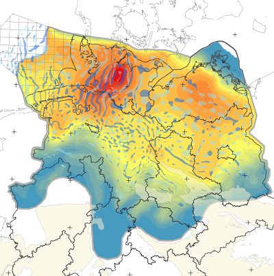
The Federal Institute for Geosciences and Natural Resources (BGR) was commissioned by the Federal Company for Radioactive Waste Disposal (BGE) within the framework of an existing cooperation agreement (BGE & BGR 2018) with the work package “Database on salt structures, variability study, and development of a prediction method for the internal structure of salt structures” (AP No.: 9S2022020000). As part of this work, well-explored salt structures were examined in detail with regard to their internal structure, and geological factors that led to the formation of the internal structure were derived from this. Using the method developed, the 60 sub-areas identified by BGE in rock salt in steeply dipping deposits can be systematically evaluated with regard to their geological conditions for finding sufficiently large host rock areas with a barrier effect (WbB). One geological factor that can be used to assess the complexity of the internal structure of salt diapirs is the primary rock salt thickness. The data available for a reliable prognosis of the spatial and proportional distribution of rock salt within salt structures in the North German Basin is currently still insufficient. In order to evaluate this geological factor for all 60 specified sub-areas, a map base for the North German Basin (NDB) with region-specific data on the primary thickness of the rock salt in the Staßfurt Formation (z2Na) is required. The data set contains grid data of the North German Basin (NDB) created as part of the work package "Datenbasis zu Salzstrukturen, Variabilitätsstudie und Entwicklung einer Prognosemethode zum Internbau von Salzstrukturen", with region-specific information on the primary thickness of the rock salt in the Staßfurt Formation (z2Na) and supplementary intermediate calculation steps in three file geodatabases (.gdb). Based on a processed, compiled basic data set, four geoscientists developed independetly different models from which a preferred model and the range, median, minimum, maximum, and mean values of all models were defined. The data will be made available shortly.
Simple
- Alternate title
-
z2Na_NDB
- Date (Creation)
- 2025-11-21
- Edition
-
Version 1.0
- Citation identifier
- https://registry.gdi-de.org/id/de.bund.bgr.csw/f752d5c1-9a67-b0c5-d95c-89cb95ab3fe4
- Citation identifier
- https://doi.org/10.25928/47dk-nc30
- Status
- Under development
-
GEMET - INSPIRE themes, version 1.0
-
-
Geology
-
Geologie
-
- Theme
-
-
Salzmächtigkeitskarte
-
Primärmächtigkeit
-
Staßfurt-Steinsalz
-
z2Na
-
- Place
-
-
Norddeutsches Becken
-
NDB
-
- Spatial representation type
- Grid
- Language
- Deutsch
- Topic category
-
- Geoscientific information
))
- Unique resource identifier
- EPSG:25832
- Distribution format
-
-
PDF
(
n/a
)
-
GDB
(
n/a
)
-
PDF
(
n/a
)
- Hierarchy level
- Dataset
Conformance result
- Date (Publication)
- 2010-12-08
- Explanation
-
siehe dazu die angegebene Durchführungsbestimmung
- Statement
-
Die Daten wurden im Rahmen des Arbeitspaketes 9S2022020000 "Datenbasis zu Salzstrukturen, Variabilitaetsstudie und Entwicklung einer Prognosemethode zum Internbau von Salzstrukturen" durch die Bundesanstalt für Geowissenschaften und Rohstoffe (BGR) erstellt. Weiterführende Informationen zu den Datenquellen enthählt Jähne-Klinberg & Paul (2025) sowie die Metadatenbeschreibung der Raster-Daten. Jähne-Klingberg, F. & Paul, B. 2025. Erstellung einer Übersichtsdarstellung zur primären Mächtigkeitsverteilung des Staßfurt-Steinsalzes (z2Na) im Norddeutschen Becken. Kurzstudie. Hannover: Bundesanstalt für Geowissenschaften und Rohstoffe (BGR), 21.11.2025
- File identifier
- fc537389-af01-4ac8-9157-d224110a1263 XML
- Metadata language
- Deutsch
- Character set
- UTF8
- Hierarchy level
- Dataset
- Hierarchy level name
-
Geologie
- Date stamp
- 2026-02-17
- Metadata standard name
-
ISO 19115
- Metadata standard version
-
2003/Cor.1:2006
Overviews
Spatial extent
Provided by
