 My GeoNetwork catalogue
global radiation
Provided by
Type of resources
Available actions
Topics
Keywords
Contact for the resource
Update frequencies
-

These data are generated by combining satellite-based and surface-measured data of the surface irradiance (global radiation) and the sunshine duration. The associated algorithms have been developed within the DUETT-project and are continuously adjusted and improved. Gridded data (EPSG-3034 projection, Germany) of the surface irradiance and the sunshine duration are generated with a spatial resolution of 2 km and a temporal resolution of 1 hour (average / sum for synoptic hours, ending at minute 50). The data set is separated into two parts: the directory ./{parameter}/recent/ contains the latest data; in the directory ./{parameter}/historical/ older data are archived.
-
These data are generated by combining satellite-based and surface-measured data of the surface irradiance (global radiation) and the sunshine duration. The associated algorithms have been developed within the DUETT-project and are continuously adjusted and improved. Gridded data (EPSG-3035 projection, Germany) of the surface irradiance and the sunshine duration are generated with a spatial resolution of 1 km and a temporal resolution of 1 hour (average / sum for synoptic hours, ending at minute 50). The data set is separated into two parts: the directory ./{parameter}/recent/ contains the latest data; in the directory ./{parameter}/historical/ older data are archived.
-

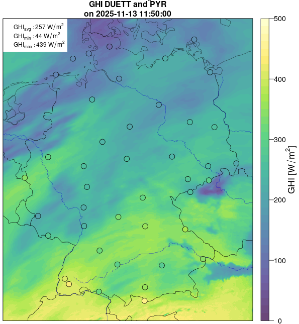
Based on the DUETT gridded data, additional point data is determined at the coordinates of 576 measurement sites of DWD. These pseudo station data are extracted from the gridded data using a simple ‘nearest neighbour’ assignment and are optimized by a subsequent topography correction. This correction is performed using high-resolution topographic data and it primarily captures the possible blocking of direct solar radiation by surrounding mountains. Associated uncertainties are also determined from the gridded data using a ‘nearest neighbour’ assignment and are not subject to any further adjustment in the current program version. The data set is separated into two parts: the directory ./{parameter}/recent/ contains the latest data; in the directory ./{parameter}/historical/ older data are archived.
-

These data originate from the stations of the DWD and legally as well as qualitatively equal partner network stations. Extensive station metadata, such as station relocations, instrument changes, reference time changes, algorithm changes or operator information are included. The quality check for these data has been completed.
-
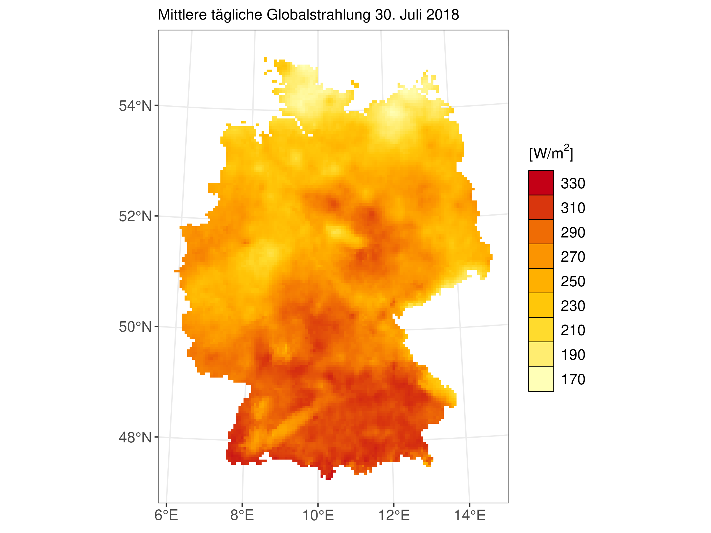
HYRAS-DE-RSDS is a global radiation product for Germany in a 5 km x 5 km grid for the period 1951-2020 and is based on daily measured values of sunshine duration and global radiation. The data set can be used, for example, for the analysis of past climate, for bias adjustment of regionalized climate projection data and as input data for hydrological modeling. It should be noted that the data was interpolated bilinearly from ETRS:3034 to ETRS:3035, as the other products are available in ETRS:3035.
-
postprocessed (downscaled an bias corrected) daily means of 2-meter-air-temperature, global radiation and daily amount of precipitation; based on regional climate projections; focussed on the period 1951-2100; gridded with 5 km horizontal spatial resolution; refers to Germany and hydrological catchment areas of Danube, Rhine, Elbe and Odra; was founded by KLIWAS (Impacts of climate change on Waterways and Navigation); provided by Department Climate and Environment Consultancy of Deutscher Wetterdienst
-
HYRAS-DE-RSDS is a global radiation product for Germany in a 5 km x 5 km grid for the period 1951-2020 and is based on daily measured values of sunshine duration and global radiation. The data set can be used, for example, for the analysis of past climate, for bias adjustment of regionalized climate projection data and as input data for hydrological modeling.
-
These data come from DWD stations and legally and qualitatively equivalent partner stations operated for climatological and climate related applications. Extensive station metadata (station relocations, instrument changes, change of reference time, changes in algorithms) are provided with the download via the CDC portal. The measurements are assigned to a timestamp in UTC which marks the end of the 10-minute interval. The solar incoming radiation includes the direct and the diffuse part of the solar radiation with respect to the horizontal plane. It is sometimes also referred to as "shortwave", including the solar spectrum up to 2.8 micron, as opposed to "longwave", which refers to the thermal radiation of the atmosphere.