 My GeoNetwork catalogue
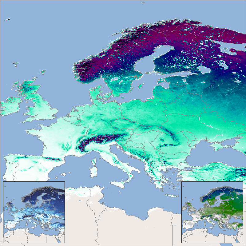
Global SnowPack - MODIS - Mean
This product shows the mean snow cover duration (SCDmean), which is updated each year and consists of the arithmetic mean for the entire time series since the hydrological year 2001. The hydrological year begins in the meteorological autumn (October 1 of the previous year in the northern hemisphere or March 1 of the reference year in the southern hemisphere) and ends with the meteorological summer (northern hemisphere: August 31 of the reference year; southern hemisphere: February 28/29 of the following year). Analogous to the annual products for snow cover duration, the entire year as well as the early season (until mid-winter) and the late season (from mid-winter) are taken into account here.
The “Global SnowPack” is derived from daily, operational MODIS snow cover product for each day since February 2000. Data gaps due to polar night and cloud cover are filled in several processing steps, which provides a unique global data set characterized by its high accuracy, spatial resolution of 500 meters and continuous future expansion. It consists of the two main elements daily snow cover extent (SCE) and seasonal snow cover duration (SCD; full and for early and late season). Both parameters have been designated by the WMO as essential climate variables, the accurate determination of which is important in order to be able to record the effects of climate change. Changes in the largest part of the cryosphere in terms of area have drastic effects on people and the environment.
For more information please also refer to:
Dietz, A.J., Kuenzer, C., Conrad, C., 2013. Snow-cover variability in central Asia between 2000 and 2011 derived from improved MODIS daily snow-cover products. International Journal of Remote Sensing 34, 3879–3902. https://doi.org/10.1080/01431161.2013.767480
Dietz, A.J., Kuenzer, C., Dech, S., 2015. Global SnowPack: a new set of snow cover parameters for studying status and dynamics of the planetary snow cover extent. Remote Sensing Letters 6, 844–853. https://doi.org/10.1080/2150704X.2015.1084 551
Dietz, A.J., Wohner, C., Kuenzer, C., 2012. European Snow Cover Characteristics between 2000 and 2011 Derived from Improved MODIS Daily Snow Cover Products. Remote Sensing 4. https://doi.org/10.3390/rs40824 32
Dietz, J.A., Conrad, C., Kuenzer, C., Gesell, G., Dech, S., 2014. Identifying Changing Snow Cover Characteristics in Central Asia between 1986 and 2014 from Remote Sensing Data. Remote Sensing 6. https://doi.org/10.3390/rs612127 52
Rößler, S., Witt, M.S., Ikonen, J., Brown, I.A., Dietz, A.J., 2021. Remote Sensing of Snow Cover Variability and Its Influence on the Runoff of Sápmi’s Rivers. Geosciences 11, 130. https://doi.org/10.3390/geosciences11030130
Simple
- Date (Creation)
- 2022-03-01T00:00:00
- Citation identifier
- https://geoservice.dlr.de/catalogue/srv/metadata/02392381-5bb0-4b28-a49d-e742fe44820b
- Presentation form
- Digital map
- Status
- ongoing
- Maintenance and update frequency
- yearly
-
GEMET - INSPIRE themes, version 1.0
-
-
Land cover
-
- Keywords
-
-
MODIS
-
Global Snow Pack
-
mean snow cover duration
-
mean snow cover duration late season
-
mean snow cover duration early season
-
snow
-
SCDmean
-
SCDEmean
-
SCDLmean
-
opendata
-
inspireidentifiziert
-
- Use limitation
-
Nutzungseinschränkungen: Das DLR ist nicht haftbar für Schäden, die sich aus der Nutzung ergeben. / Use Limitations: DLR not liable for damage resulting from use.
- Access constraints
- Other restrictions
- Other constraints
- Es gelten keine Zugriffsbeschränkungen
- Use constraints
- Other restrictions
- Other constraints
-
Nutzungsbedingungen: Lizenz, https://creativecommons.org/licenses/by/4.0 / Terms of use: License, https://creativecommons.org/licenses/by/4.0
- Other constraints
-
{"id": "cc-by/4.0",
"name": "Creative Commons Namensnennung - Attribution 4.0 International (CC BY 4.0)",
"url": " http://dcat-ap.de/def/licenses/cc-by/4.0 ",
"quelle": "Copyright DLR (2022)"}
- Spatial representation type
- Grid
- Denominator
- 920000
- Language
- English
- Character set
- UTF8
- Topic category
-
- Climatology, meteorology, atmosphere
))
- Begin date
- 2000-01-01T00:00:00
- End date
- 2022-02-28T00:00:00
- Unique resource identifier
- EPSG:4326
- Number of dimensions
- 2
- Dimension name
- Column
- Dimension size
- 86400
- Resolution
- 460 m
- Dimension name
- Row
- Dimension size
- 43200
- Resolution
- 460 m
- Cell geometry
- Area
- Transformation parameter availability
- No
- Distribution format
-
-
GeoTIFF
()
-
GeoTIFF
()
- OnLine resource
-
GSP_SCD_MEAN
(
OGC:WMS
)
Global SnowPack - Mean Snow Cover Duration (SCDmean)
- OnLine resource
-
GSP_SCDE_MEAN
(
OGC:WMS
)
Global SnowPack - Mean Snow Cover Duration Early Season (SCDE)
- OnLine resource
-
GSP_SCDL_MEAN
(
OGC:WMS
)
Global SnowPack - Mean Snow Cover Duration Late Season (SCDL)
- OnLine resource
- https://geoservice.dlr.de/eoc/land/wms?SERVICE=WMS%26REQUEST=GetCapabilities ( OGC:WMS-http-get-capabilities )
- OnLine resource
- EOC Geoservice map context ( WWW:LINK-1.0-http--link )
- OnLine resource
- EOC Download Service ( WWW:LINK-1.0-http--link )
- OnLine resource
- Global SnowPack - EOC News ( WWW:LINK-1.0-http--link )
- Hierarchy level
- Dataset
Domain consistency
- Measure identification
- INSPIRE / Conformity_001
Conformance result
- Date (Publication)
- 2010-12-08
- Explanation
-
See the referenced specification.
- Pass
- Yes
- Statement
-
Created from MODIS daily snow cover products MOD10A1, MYD10A1 provided by the National Snow and Ice Datacenter NSIDC ( https://nsidc.org/ )
Processing steps include combination of observations recorded by Aqua and Terra, temporal interpolation of 3 successive days, snow line identification, and a seasonal filter. More details are available in the publication "Dietz A.J., Kuenzer, C., and Dech, S. (2015): Global SnowPack: a new set of snow cover parameters for studying status and dynamics of the planetary snow cover extent; Remote Sensing Letters 6, No. 11. pp. 844-853
- Description
-
Single day snow cover datasets MOD10A1 and MYD10A1 were first cleared of any clouds/data gaps/polar darkness areas using 4 different interpolation techniques, then merged to produce the seasonal products.
Accuracy of the seasonal product ranges between 77% and 85%, depending on the location and the duration of data gaps caused by clouds or darkness.
- File identifier
- 02392381-5bb0-4b28-a49d-e742fe44820b XML
- Metadata language
- English
- Character set
- UTF8
- Hierarchy level
- Dataset
- Hierarchy level name
-
Dataset
- Date stamp
- 2024-06-20T13:08:19
- Metadata standard name
-
ISO 19115-1:2014/19139
- Metadata standard version
-
2003/Cor.1:2006
Overviews
Spatial extent
Provided by
