 www.geodatenkatalog.de (S3L)
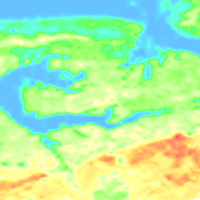
Helicopter-borne Radiometrics (HRD) Area 124 Stassfurt
BGR conducted an airborne survey in the region of the Stassfurt-Egeln salt anticline as part of a BMBF research project "Dynamic processes in flooded or abandoned salt mines and their overburden”. The survey area Stassfurt (2007) is bounded by the towns and settlements Aschersleben, Kroppenstedt, Hadmersleben, Altenweddingen, Atzendorf, Förderstedt and Bernburg. The size of the area is about 467 km². The area was surveyed with 29 flights totalling 5034 line-km (132,390 survey points). The nominal separation of the 155 SE-NW lines and 33 NE-SW tie lines was 100 m and 1000 m, respectively. The maps display the total count, the (equivalent) content of potassium, uranium and thorium as well as the exposure rate at ground.
|
|
Citation proposal
(2010) . Helicopter-borne Radiometrics (HRD) Area 124 Stassfurt. https://gdk.gdi-de.org/geonetwork/srv/api/records/0255dc2f-fabc-45be-bf99-34b4d5ed3574 |
Simple
- Alternate title
- 124StassfurtHRD
- Date ( Publication )
- 2010-03-01
- Identifier
- 126dd945-aa18-4937-693b-9827fb88f491
- Identifier
- https://doi.org/10.25928/5pz9-dp89
- Status
- completed Completed
Point of contact
Bundesanstalt für Geowissenschaften und Rohstoffe (BGR)
-
Siemon, Bernhard, Dr.
Stilleweg 2
Hannover
30655
Deutschland
- GEMET - INSPIRE themes, version 1.0 ( Theme )
-
- Geologie
- Geology
- GEMET - Concepts, version 2.4 ( Theme )
-
- Geophysik
- Keywords ( Theme )
-
- Aerogeophysik
- Hubschrauber-Radiometrie
- Äquivalentgehalte
- Thorium
- Uran
- Kalium
- Ionendosisleistung
- Airborne geophysics
- helicopter-borne radiometrics
- equivalent concentrations
- Uranium
- Potassium
- exposure rate
- Keywords ( Place )
-
- Sachsen-Anhalt
- Access constraints
- Other restrictions
- Use constraints
- Other restrictions
- Other constraints
- Allgemeine Geschäftsbedingungen, siehe https://www.bgr.bund.de/AGB - General terms and conditions, see https://www.bgr.bund.de/AGB_en. Die bereitgestellten Informationen sind bei Weiterverwendung wie folgt zu zitieren: Datenquelle: 124StassfurtHRD, (c) BGR, Hannover, 2010, doi:10.25928/5pz9-dp89.
- Spatial representation type
- Grid
- Metadata language
- German
- Character set
- UTF8
- Topic category
-
- Geoscientific information
N
S
E
W
))
- Distribution format
-
- georef. TIFF (n/a )
- PDF (n/a )
- Transfer size
- 55
- OnLine resource
-
124StassfurtHRD (georef. TIFF)
124StassfurtHRD im Format georef. TIFF
- Transfer size
- 77
- OnLine resource
-
124StassfurtHRD (PDF)
124StassfurtHRD im Format Adobe Acrobat
- OnLine resource
-
Projektbeschreibung
Projektbeschreibung
- OnLine resource
-
Publikation in First Break
Publikation in First Break
- OnLine resource
-
Technischer Bericht Archiv-Nr. 0128730
Technischer Bericht Archiv-Nr. 0128730
- Hierarchy level
- Dataset
Conformance result
- Date ( Publication )
- 2010-12-08
- Explanation
- siehe dazu die angegebene Durchführungsbestimmung
- Statement
- Erarbeitung im Rahmen des BMBF-Forschungsvorhabens "Dynamik abgesoffener oder gefluteter Salzbergwerke und ihres Deckgebirgsstockwerks" (Stassfurt) - Förderkennzeichen: 02C1476
gmd:MD_Metadata
- File identifier
- 0255dc2f-fabc-45be-bf99-34b4d5ed3574 XML
- Metadata language
- German
- Character set
- UTF8
- Parent identifier
- ac818fce-f429-449c-85cf-6c838db1d0da
- Hierarchy level
- Dataset
- Hierarchy level name
- Geophysik
- Date stamp
- 2022-11-16
- Metadata standard name
- INSPIRE Metadata Implementing Rules: Technical Guidelines based on EN ISO 19115 and EN ISO 19119
- Metadata standard version
- n/a
Point of contact
Overviews
Provided by

Views
0255dc2f-fabc-45be-bf99-34b4d5ed3574
Access to the portal
Read here the full details and access to the data.
Associated resources
Not available