 My GeoNetwork catalogue
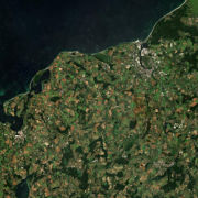
Sentinel-2 MSI - Level 3A (MAJA/WASP Tiles) - Germany
This collection contains synthesized Sentinel-2 Level 3A surface reflectances for Germany on a monthly basis computed by the WASP processor (which utilizes L2A products derived from the MAJA processor). During the Level 3A processing, atmospherically corrected data from a predefined time interval are collected, weighted based on temporal distance and integrated to a new data set with the aim of removing clouds. Thereby, monthly Sentinel-2 Level 3A composites are provided for whole Germany. Please see https://logiciels.cnes.fr/en/content/maja for additional information on the MAJA product.
Further Sentinel-2 Level 3A data computed using MAJA are available on the following website: https://theia.cnes.fr
- Identification
- Distribution
- Quality
- Spatial rep.
- Ref. system
- Content
- Portrayal
- Metadata
- Md. constraints
- Md. maintenance
- Schema info
Identification
Data identification
Citation
- Date (Creation)
- 2019-12-11T08:27:00
- Citation identifier
- https://geoservice.dlr.de/catalogue/srv/metadata/03c193e6-c1b7-49b9-9edb-cd29aeabae5f
- Presentation form
- Digital image
- Other citation details
-
DOI: 10.15489/4hcq6dgkj648
- Status
- On going
- Maintenance and update frequency
- Continual
- Keywords
-
-
Satellite
-
Earth Observation
-
Multispectral
-
Sentinel-2
-
MSI
-
Level 3A
-
MAJA
-
WASP
-
Monthly composites
-
DLR
-
Atmospheric Correction
-
Cloud Detection
-
Germany
-
-
GEMET - INSPIRE themes, version 1.0
-
-
Orthoimagery
-
Legal constraints
- Access constraints
- License
- Use constraints
- Other restrictions
- Other constraints
-
Nutzungsbedingungen / Terms of use: The Sentinel-2 level 3A data produced and distributed by DLR are based on Copernicus Sentinel-2 level 1C data, which are subject to the following license: https://theia.cnes.fr/atdistrib/documents/TC_Sentinel_Data_31072014.pdf
- Other constraints
-
{"id": "cc-by-4.0",
"name": "Creative Commons Namensnennung 4.0 International (CC BY 4.0)",
"url": " https://www.dcat-ap.de/def/licenses/ ",
"quelle": "German Aerospace Center (DLR): Sentinel-2 MSI - Level 2A (MAJA Tiles) - Germany, DOI: 10.15489/ifczsszkcp63 or Contains modified Copernicus Sentinel data, processed by DLR, licensed under CC BY 4.0"}
- Use limitation
-
Nutzungseinschränkungen: Das DLR ist nicht haftbar für Schäden, die sich aus der Nutzung ergeben. / Use Limitations: DLR not liable for damage resulting from use.
- Spatial representation type
- Grid
- Denominator
- 20000
- Language
- English
- Character set
- UTF8
- Topic category
-
- Imagery base maps earth cover
Extent
))
- Begin date
- 2015-06-01T00:00:00
Distribution
Distribution
- Distribution format
-
-
(
)
-
(
)
Digital transfer options
- OnLine resource
- EOC Geoservice Dataset ( WWW:LINK-1.0-http--link )
- OnLine resource
- Information on WASP algorithm and L3A product ( WWW:LINK-1.0-http--link )
- OnLine resource
- Description of MAJA L2A product (used for L3A product generation) ( WWW:LINK-1.0-http--link )
- OnLine resource
- Description of MAJA algorithm and related reference ( WWW:LINK-1.0-http--link )
- OnLine resource
- Access to WASP source code ( WWW:LINK-1.0-http--link )
- OnLine resource
- Theia platform for downloading further MAJA L3A products ( WWW:LINK-1.0-http--link )
- OnLine resource
-
HTTP Download
(
WWW:LINK-1.0-http--link
)
HTTP Download (Sentinel-2 L3A WASP)
- OnLine resource
- EOC STAC Collection ( WWW:LINK-1.0-http--link )
- OnLine resource
-
S2_L3A_WASP_DTS_P1M
(
OGC:WMS
)
WMS access: Sentinel-2 L3A DTS (WASP)
- OnLine resource
-
S2_L3A_WASP_FLG_P1M
(
OGC:WMS
)
WMS access: Sentinel-2 L3A FLG (WASP)
- OnLine resource
-
S2_L3A_WASP_FRC_P1M
(
OGC:WMS
)
WMS access: Sentinel-2 L3A FRC (WASP)
- OnLine resource
- https://geoservice.dlr.de/eoc/imagery/wms?SERVICE=WMS&REQUEST=GetCapabilities ( OGC:WMS-http-get-capabilities )
- OnLine resource
-
S2_L3A_WASP_DTS_P1M
(
OGC:WCS
)
WCS access: Sentinel-2 L3A DTS (WASP)
- OnLine resource
-
S2_L3A_WASP_FLG_P1M
(
OGC:WCS
)
WCS access: Sentinel-2 L3A FLG (WASP)
- OnLine resource
-
S2_L3A_WASP_FRC_P1M
(
OGC:WCS
)
WCS access: Sentinel-2 L3A FRC (WASP)
- OnLine resource
- https://geoservice.dlr.de/eoc/imagery/wcs?SERVICE=WCS&REQUEST=GetCapabilities ( OGC:WCS-http-get-capabilities )
- OnLine resource
-
EOC Geoservice Map Context
(
WWW:LINK-1.0-http--link
)
EOC Geoservice Map Context (sentinel2:l3a:wasp)
Quality
Data quality
- Hierarchy level
- Series
Domain consistency
- Measure identification
- INSPIRE / Conformity_001
Conformance result
Citation
- Date (Publication)
- 2010-12-08
- Explanation
-
See the referenced specification
- Pass
- Yes
Lineage
- Statement
-
Input data sets: Sentinel-2 L2A MAJA data
- Description
-
Sentinel-2 L3A data are generated by the WASP software, using the CATENA framework at DLR. Please see the following website for further information: https://labo.obs-mip.fr/multitemp/theias-sentinel-2-l3a-monthly-cloud-free-syntheses/
Ref. system
- Reference system identifier
- EPSG / WGS 84 (EPSG:4326) / 7.4
Metadata
Metadata
- File identifier
- 03c193e6-c1b7-49b9-9edb-cd29aeabae5f XML
- Metadata language
- English
- Character set
- UTF8
- Hierarchy level
- Series
- Hierarchy level name
-
Dataseries
- Date stamp
- 2025-02-03T08:57:53
- Metadata standard name
-
ISO 19115:2003/19139
- Metadata standard version
-
1.0
Overviews

Spatial extent
Provided by
