 My GeoNetwork catalogue
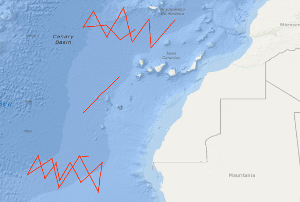
Processed seismic data of Cruise BGR85 1985
A geophysical reconnaissance survey across oceanic fracture zones has been carried out by the BGR in the eastern North Atlantic using S.V. PROSPEKTA. The geophysical measurements, including multichannel seismic reflection profiling, magnetics and gravity were concentrated on three oceanic crustal areas of Mesozoic crust which are crossed by the Hayes Fracture Zone, the Atlantis Fracture Zone and the Kane Fracture Zone respectively. 24 geophysical lines with a total length of 5,362 km have been measured during the time period from 25th October to 4th December 1985. Besides intracrustal seismic events a deep coherent seismic event is often recognizable in the monitor records between 10 - 12 s (TWT) along several lines, which probably is a reflection from the crust-mantle boundary.
- Identification
- Distribution
- Quality
- Spatial rep.
- Ref. system
- Content
- Portrayal
- Metadata
- Md. constraints
- Md. maintenance
- Schema info
Identification
Data identification
Citation
- Alternate title
-
BGR85 1985
- Date (Creation)
- 1985-12-04
- Citation identifier
- c91b531e-9344-e44d-097c-3a2697556f52
- Status
- Completed
-
GEMET - INSPIRE themes, version 1.0
-
-
Geologie
-
geology
-
-
GEMET - Concepts, version 2.4
-
-
geophysics
-
Geophysik
-
raw material
-
Rohstoff
-
- Theme
-
-
Marine geology
-
Meeresgeologie
-
Seismics
-
Seismik
-
Two-dimensional seismic reflection
-
zweidimensionale Reflektionsseismik
-
- Place
-
-
Northeast Atlantic Ocean
-
Nordost-Atlantik
-
West Africa
-
Westafrika
-
Canary Basin
-
Kanarenbecken
-
Hayes Fracture Zone
-
Kane Fracture Zone
-
Atlantis Fracture Zone
-
Legal constraints
- Access constraints
- Other restrictions
- Other constraints
- Es gelten keine Zugriffsbeschränkungen
Legal constraints
- Use constraints
- Other restrictions
- Other constraints
-
Allgemeine Geschäftsbedingungen, siehe http://www.bgr.bund.de/AGB - General terms and conditions, see http://www.bgr.bund.de/AGB_en . Die bereitgestellten Informationen sind bei Weiterverwendung wie folgt zu zitieren: Datenquelle: BGR85 1985, (c) BGR, Hannover, 1985
- Spatial representation type
- Vector
- Language
- English
- Character set
- UTF8
- Topic category
-
- Geoscientific information
))
Distribution
Distribution
- Distribution format
-
-
Shapefile
(
n/a
)
-
Shapefile
(
n/a
)
Digital transfer options
- Transfer size
- 2
- OnLine resource
-
BGR85 1985 (Shapefile)
BGR85 1985 im Format ESRI Shape
- OnLine resource
- Profile BGR85-16
- OnLine resource
- Profile BGR85-17
- OnLine resource
- Profile BGR85-18
- OnLine resource
- Profile BGR85-19B
- OnLine resource
- Profile BGR85-20A
- OnLine resource
- Profile BGR85-20B
- OnLine resource
- Profile BGR85-21
- OnLine resource
- Profile BGR85-22
- OnLine resource
- Profile BGR85-23
- OnLine resource
- Profile BGR85-24A
- OnLine resource
- Profile BGR85-24B
- OnLine resource
- Profile BGR85-25
- OnLine resource
- Profile BGR85-26
- OnLine resource
- Profile BGR85-27
- OnLine resource
- Profile BGR85-28
- OnLine resource
- Karte im BGR-Geoviewer
Quality
Data quality
Scope
- Hierarchy level
- Dataset
Conformance result
Citation
- Date (Publication)
- 2010-12-08
- Explanation
-
siehe dazu die angegebene Durchführungsbestimmung
- Statement
-
During the period from the 25th October to the 4th December 1985 BGR acquired 24 seismic lines off West Africa in the Canary Basin at the Hayes, Atlantis and Kane Fracture Zones. The lines from BGR85-01B to BGR85-15 consist of raw data, the lines BGR85-23, BGR85-24A, BGR85-24B and BGR85-25 are stacked data, the lines BGR85-16, BGR85-17, BGR85-18, BGR85-19B, BGR85-20A, BGR85-20B, BGR85-21, BGR85-22, BGR85-26, BGR85-27 and BGR85-28 are migrated data.
Ref. system
- Unique resource identifier
- EPSG:4326
Metadata
Metadata
- File identifier
- 045ca385-098f-46c2-a117-4ccaa96f6967 XML
- Metadata language
- English
- Character set
- UTF8
- Parent identifier
-
Marine Seismic Survey Profiles (MSSP)
06a73c56-06a2-40d8-b806-466222b0760d
- Hierarchy level
- Dataset
- Hierarchy level name
-
Geophysik
- Date stamp
- 2023-11-14
- Metadata standard name
-
INSPIRE Metadata Implementing Rules: Technical Guidelines based on EN ISO 19115 and EN ISO 19119
- Metadata standard version
-
n/a
Overviews
Spatial extent
Provided by
