 www.geodatenkatalog.de (S3L)
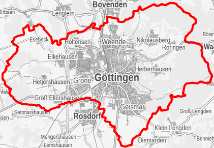
Statistische Bezirke und Baublöcke der Stadt Göttingen
Die Stadt Göttingen ist in 69 statistische Bezirke unterteilt. Diese Grenzen bilden die Basis für statistische Auswertungen. Die Baublöcke untergliedern die 69 Statistischen Bezirke in kleinere Einheiten. Die kartographische Basis für die Darstellung der kleinräumigen Gliederung basiert auf dem Göttinger Stadtkartenwerk.
|
|
Citation proposal
(2015) . Statistische Bezirke und Baublöcke der Stadt Göttingen. https://gdk.gdi-de.org/geonetwork/srv/api/records/08ff37b2-7917-4fe5-a890-eeda108b06d4 |
- Identification
- Distribution
- Quality
- Spatial rep.
- Ref. system
- Content
- Portrayal
- Metadata
- Md. constraints
- Md. maintenance
- Schema info
Identification
Data identification
Citation
- Date ( Publication )
- 2015-09-01
Point of contact
Stadt Göttingen
-
Mitarbeiter/innen Referat "Statistik und Wahlen"
(Referatsleitung )
Hiroshimaplatz 1-4
Göttingen
Niedersachsen
37083
Deutschland
- GEMET - INSPIRE themes, version 1.0 ( Theme )
-
- Stadtplanung
- Stadtentwicklung
- Demographie
- Statistik
- Regionalstatistik
- Datenanalyse
- Statistische Daten
- kleinräumige Gliederung
- Baublock
- Statistische Einheiten
Resource constraints
No information provided.
Resource constraints
No information provided.
Resource constraints
No information provided.
Resource constraints
No information provided.
Resource constraints
No information provided.
Resource constraints
No information provided.
Resource constraints
No information provided.
Resource constraints
No information provided.
Resource constraints
No information provided.
Resource constraints
No information provided.
- Classification
- Restricted
- Use limitation
- Nutzungsvereinbarung
- Access constraints
- Restricted
- Use constraints
- Restricted
- Metadata language
- German
- Character set
- UTF8
- Topic category
-
- Society
N
S
E
W
))
Distribution
Distribution
- Distribution format
-
- Shape-File, DXF, PDF (10.2 )
Point of contact
Stadt Göttingen
-
Mitarbeiter/innen Referat "Statistik und Wahlen"
(Sachbearbeitung )
Hiroshimaplatz 1-4
Göttingen
Niedersachsen
37083
Deutschland
Quality
Data quality
Scope
- Hierarchy level
- Dataset
Conformance result
Citation
- Date ( Publication )
- 2015-09-01
- Explanation
- Die Daten sind konform.
- Pass
- true
- Statement
- Erfassung und kartografische Darstellung auf Grundlage der Göttinger Stadtkartenwerke.
Ref. system
Identifier
- Version
- 6.11.2
Metadata
Metadata
- File identifier
- 08ff37b2-7917-4fe5-a890-eeda108b06d4 XML
- Metadata language
- German
- Character set
- UTF8
- Hierarchy level
- Dataset
- Date stamp
- 2023-01-12
- Metadata standard name
- ISO 19115/19119
Point of contact
Stadt Göttingen
-
Mitarbeiter/innen Fachdienst "Geoservice und Grundstücke"
Hiroshimaplatz 1-4
Göttingen
Niedersachsen
37083
Deutschland
Overviews
Provided by

Views
08ff37b2-7917-4fe5-a890-eeda108b06d4
Access to the portal
Read here the full details and access to the data.
Associated resources
Not available