 www.geodatenkatalog.de (S2L)
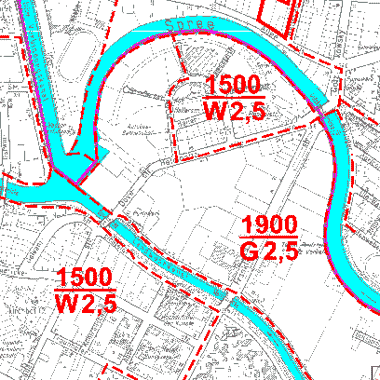
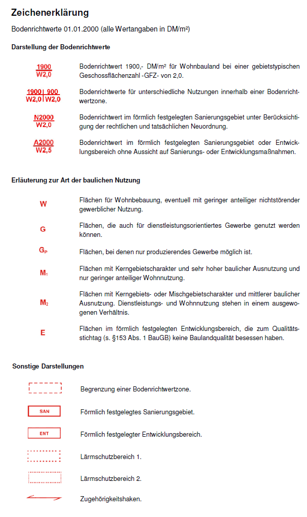
Bodenrichtwerte 01.01.2000
Bodenrichtwertatlas basierend auf den Rasterdaten des Gutachterausschusses für Grundstückswerte in Berlin vom 01.01.2000. Die Bodenrichtwerte sind in DM/m² angegeben!
|
|
Citation proposal
(2000) . Bodenrichtwerte 01.01.2000. https://gdk.gdi-de.org/geonetwork/srv/api/records/091d4f0c-130c-3aae-9590-3767376f66fa |
Simple
Identification info
- Date ( Creation )
- 2000-01-01
- Date ( Publication )
- 2000-02-08
- Date ( Revision )
- 2000-05-16
- Presentation form
- Digital map
Point of contact
Point of contact
- Keywords ( Theme )
-
- Karten
- Geodaten
- Berlin
- Werte
- Preise
- Wertermittlung
- Gutachterausschuss
- Bodenrichtwertatlas
- Grundstück
- GAA
- Bodenrichtwerte
- Access constraints
- Other restrictions
- Use constraints
- Other restrictions
- Other constraints
- Für die Nutzung der Daten ist die Datenlizenz Deutschland - Namensnennung - Version 2.0 anzuwenden. Die Lizenz ist über https://www.govdata.de/dl-de/by-2-0 abrufbar. Der Quellenvermerk gemäß (2) der Lizenz lautet "Geoportal Berlin / [Titel des Datensatzes]" oder "Gutachterausschuss für Grundstückswerte in Berlin".
- Other constraints
- { "id": "dl-by-de/2.0" , "name": " Datenlizenz Deutschland - Namensnennung - Version 2.0 ", "url": "https://www.govdata.de/dl-de/by-2-0", "quelle": "Geoportal Berlin / [Titel des Datensatzes] oder Gutachterausschuss für Grundstückswerte in Berlin" }
- Service Type
- view
- Service Version
- OGC:WMS 1.0.0
- Service Version
- OGC:WMS 1.1.0
- Service Version
- OGC:WMS 1.1.1
- Service Version
- OGC:WMS 1.3.0
N
S
E
W
))
- Extent type code
- true
- Geographic identifier
- 110000000000
- Coupling Type
- Tight
Contains Operations
- Operation Name
- GetCapabilities
- Distributed Computing Platforms
- Web services
- Connect Point
- https://fbinter.stadt-berlin.de/fb/wms/senstadt/brw2000
- Reference system identifier
- http://www.opengis.net/def/crs/EPSG/0/3068
- Distribution format
-
- Text/HTML (4.01 )
- OnLine resource
-
GetCapabilities Aufruf des WMS mit maschinenlesbarer Antwort
GetCapabilities Aufruf des WMS mit maschinenlesbarer Antwort
- OnLine resource
-
Aufruf des Geoportals Berlin mit Darstellung der Karte und weiterer Metadaten
Aufruf des Geoportals Berlin mit Darstellung der Karte und weiterer Metadaten
- OnLine resource
-
Inhaltliche Beschreibung
Inhaltliche Beschreibung
- Hierarchy level
- Service
- Other
- Dienst
gmd:MD_Metadata
- File identifier
- 091d4f0c-130c-3aae-9590-3767376f66fa XML
- Metadata language
- German
- Character set
- UTF8
- Hierarchy level
- Service
- Hierarchy level name
- Bodenrichtwerte 01.01.2000 Dienst
- Date stamp
- 2024-02-20T12:46:42
- Metadata standard name
- ISO 19115/19119 – BE
- Metadata standard version
- 1.0.0
Overviews
Vorschaugrafik
Legende
Provided by

Views
091d4f0c-130c-3aae-9590-3767376f66fa
Access to the portal
Read here the full details and access to the data.
Associated resources
Not available